Download

1 / 59
590 likes | 700 Views
CUAHSI Hydrologic Information Systems. By David R. Maidment

E N D
CUAHSI Hydrologic Information Systems By David R. Maidment With support from many collaborators: Ilya Zaslavsky, Reza Wahadj, Chaitan Baru, Praveen Kumar, Michael Piasecki, Rick Hooper, Jon Duncan, David Tarboton, Jeff Horsburgh, Venkat Lakshmi, Chunmaio Zheng, Xu Liang, Yao Liang, Ken Reckhow, Upmanu Lall, LeRoy Poff, Dennis Lettenmaier, Barbara Minsker, …… And many graduate students and post-docs: Venkatesh Merwade, Tim Whiteaker, Jon Goodall, Gil Strassberg, Ben Ruddell, Luis Bermudez, Bora Boran, …… Thanks to everyone for all their help!
CUAHSI-Hydrologic Information Systems UCAR • CUAHSI –Consortium of Universities for the Advancement of Hydrologic Science, Inc • Formed in 2001 as a legal entity • Program office in Washington (5 staff) • Rick Hooper is Executive Director Unidata Atmospheric Sciences Earth Sciences Ocean Sciences CUAHSI NSF Geosciences Directorate HIS
CUAHSI Member Institutions 101 Universities as of November 2005
Environmental Cyberinfrastructure • Part of NSF Cyberinfrastructure program • CUAHSI Hydrologic Information Systems is one of several pilot projects – CUAHSI, CLEANER, ORION, NEON, …..
Project co-PI Collaborator CUAHSI HIS Partner Institutions
HIS Goals • Hydrologic Data Access System – better access to a large volume of high quality hydrologic data • Support for Observatories – synthesizing hydrologic data for a region • Advancement of Hydrologic Science – data modeling and advanced analysis • Hydrologic Education – better data in the classroom, basin-focused teaching
HIS Goals • Hydrologic Data Access System – better access to a large volume of high quality hydrologic data • Support for Observatories – synthesizing hydrologic data for a region • Advancement of Hydrologic Science – data modeling and advanced analysis • Hydrologic Education – better data in the classroom, basin-focused teaching
HIS User Assessment (Chapter 4 in Status Report) Which of the four HIS goals is most important to you? Data Access Observatory support Science Education
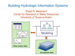
CUAHSI Hydrologic Data Access System(HDAS) NCDC NASA EPA NWS USGS Observatory Data A common data window for accessing, viewing and downloading hydrologic information
CUAHSI Web Services Web application: Data Portal • Your application • Excel, ArcGIS, Matlab • Fortran, C/C++, Visual Basic • Hydrologic model • ……………. • Your operating system • Windows, Unix, Linux, Mac Internet Simple Object Access Protocol Web Services Library
NWIS Station Information in HDAS http://river.sdsc.edu/HDAS
Observation Site Files Ameriflux Towers Automated Surface Observing System Climate Reference Network USGS NWIS Stations
Observation Site Map for US USGSNWIS ASOS Climate Research Network Ameriflux + others…….
Neuse Basin with all points NWIS Streamflow and Water Quality ASOS Ameriflux NWIS Groundwater NARR
Filtered Site Map NWIS Streamflow and Water Quality ASOS Ameriflux NARR
http://public.ornl.gov/ameriflux/ Ameriflux site map Building each web service requires a site map and a web services library Ameriflux towers measure vertical fluxes of water, heat, CO2 Web services library
NAWQA Ameriflux Storet LTER NCDC NCAR NWIS CUAHSI Web Services Excel Visual Basic ArcGIS C/C++ Matlab Fortran Access SAS Some operational services
Direct and Indirect Web Services • Direct web service • The data agency provides direct querying ability into its archives through SOAP or OpenDAP (NCDC) • Indirect web service • CUAHSI constructs a “web page mimic” service, housed at SDSC, that programmatically mimics the manual use of an agency’s web pages (USGS, Ameriflux)
HydroObjects Library • CUAHSI has developed a HydroObjects Library with web service wrappers that know where to access each web service and how to interpret its output User Application (Excel, ArcGIS, …..) HydroObjects Library with web service wrappers for NWIS, Ameriflux, NCDC, … Direct or Indirect web services Web data
Standards are the Key • standards … • Industry standards already exists: • SOAP = Simple Object Access Protocol • WSDL = Web Service Definition Language • Hydrologic community must add their own to the mix: • HTSS = Hydrologic Time Series Service • HML = Hydrologic Markup Language • software development … • If we adopt SOAP and WSDL standards, we can utilize industry support • Hydrology standards will increase interoperability and code reuse • Request SWAQ to set up an advisory committee for to help develop CUAHSI standards for HML
Utah State Time Series Analyst(developed by Jeff Horsburgh) http://water.usu.edu/nwisanalyst/ -- operates on CUAHSI web services -- operates on local data for Neuse basin http://water.usu.edu/analyzer/
Transfer of research results • CUAHSI web services for NWIS were announced at a cyberseminar on Friday Oct 28 • On Wednesday Nov 2, Jason Love, from a private firm, RESPEC, in Sioux Falls, South Dakota, posted on the EPA Basins list server:“Occasionally one comes across something that is worth sharing; the CUAHSI Hydrologic Information Systems - Web Services Library for NWIS is a valuable tool for those of us interested in rapidly acquiring and processing data from the USGS, e.g., calibrating models and performing watershed assessments.” • He provided a tutorial on how to use the services from Matlab (which CUAHSI had not developed) • Technology transfer took less than 1 week!
Impact of Web Services • CUAHSI web data services are significantly simplifying user access to federal water observation data • This will increase appreciation of the collective information content of these data • Next step is to set the data in context of their environment – Digital Watershed • Web services mayturn out to be as important or evensupersede web pagesas a data delivery mechanism
HIS Goals • Hydrologic Data Access System – get me the data I want quickly and painlessly • Support for Observatories – synthesizing hydrologic data for a region • Advancement of Hydrologic Science – data modeling and advanced analysis • Hydrologic Education – better data in the classroom, basin-focused teaching
Digital Watershed How can hydrologists integrate observed and modeled data from various sources into a single description of the environment?
Digital Watershed Hydrologic Observation Data Geospatial Data (GIS) (Relational database) Digital Watershed Remote Sensing Data Weather and Climate Data (EOS-HDF) (NetCDF) A digital watershed is a synthesis of hydrologic observation data, geospatial data, remote sensing data and weather and climate data into a connected database for a hydrologic region
Digital Watershed:Prototype for the Neuse basin (See Chapter 8 in the Status Report for details)
Neuse Atmospheric Water • Daily precipitation data from NCDC gages • Nexrad daily rainfall rasters • Land surface – atmosphere fluxes from North American Regional Reanalysis of climate
Streamflow, water quality hydrologic observational data GIS: River network, water bodies, watersheds, monitoring points Land cover, soils, MODIS remote sensing (Praveen Kumar and Venkat Lakshmi) Neuse Surface Water MODIS Terrain and Land Cover
Neuse Basin: Coastal aquifer system Section line Beaufort Aquifer * From USGS, Water Resources Data Report of North Carolina for WY 2002
Neuse Groundwater Geovolumes of hydrogeologic units from US Geological survey (GMS)
GeoVolume – 3D representation of the surface and subsurface Geovolume Geovolume with groundwater model cells Geovolume of layered soil texture for the Neuse basin
Digital Site • Provides the community with a systematically constructed archive of site investigations • A means of constructive engagement with scientists on standardized databases for site scale processes • A library of digital sites of different kinds informs digital watershed development MADE site in Mississippi
Connecting Arc Hydro and Hydrologic Models GIS Interfacedata models HEC-HMS Geo Database Arc Hydro data model HEC-RAS HSPF
FLOODPLAIN MAP Map2Map Workflow Model DEMO Flood map as output Model for flood flow HMS Model for flood depth Nexrad rainfall map as input
HIS Goals • Hydrologic Data Access System – better access to a large volume of high quality hydrologic data • Support for Observatories – synthesizing hydrologic data for a region • Advancement of Hydrologic Science – data modeling and advanced analysis • Hydrologic Education – better data in the classroom, basin-focused teaching
Towards a Feasible Environmental Observatory:A Vision and an Implementation Plan Richard P. HooperPresident, CUAHSI
CUAHSI Community Challenge Predict flux of water and chemicals in rivers, lakes, aquifers, and estuaries continuously in time and space throughout the United States.
Digital Watershed:An implementation of the CUAHSI Hydrologic Data Model for a particular region Created first for the Neuse basin
CUAHSI Hydrologic Information System Multiscale web portal delivering point water observation data, GIS data, weather and climate data and remote sensing data for user selected regions in the United States National Scale (seamless, coast to coast data coverage, ArcHydro USA) 1:500,000 scale Multiscale data delivery Regional Scale (e.g. Neuse basin) 1:100,000 scale Watershed Scale (e.g. Trent watershed ) 1:24,000 scale Site Scale (experimental site level) Site scale
Hydrologic Information System Hydrologic Observing System Hydrologic Modeling System National Hydrologic Information System
HydroVolumes Take a watershed and extrude it vertically into the atmosphere and subsurface A hydrovolume is “a volume in space through which water, energy and mass flow, are stored internally, and transformed”
Watershed Hydrovolumes Hydrovolume Geovolume is the portion of a hydrovolume that contains solid earth materials USGS Gaging stations
Hydrologic Flux Coupler Hydrologic Fluxes and Flows Digital Watershed(Atmospheric, surface and subsurface water) We want to do water, mass, energy and water balances
Hydrologic Flux Coupler Define the fluxes and flows associated with each hydrovolume Evaporation Precipitation Streamflow See Chapter 9 of Status Report for Details Groundwater recharge
Hydrologic Science It is as important to represent hydrologic environments precisely with data as it is to represent hydrologic processes with equations Physical laws and principles (Mass, momentum, energy, chemistry) Hydrologic Process Science (Equations, simulation models, prediction) Hydrologic conditions (Fluxes, flows, concentrations) Hydrologic Information Science (Observations, data models, visualization Hydrologic environment (Dynamic earth)
Shared Data Models Environmental Engineering (CLEANER) Significant progress Geology (GEON) Ecology (NEON/LTER) Hydrology (CUAHSI) Atmospheric Science (NCAR/Unidata) Geomorphology (NCED/WSSC) Limnology, Ocean science, …..