Download
1 / 48
480 likes | 583 Views
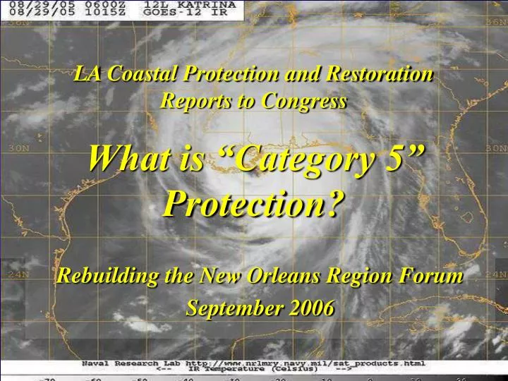
LA Coastal Protection and Restoration Reports to Congress What is “Category 5” Protection?. Rebuilding the New Orleans Region Forum September 2006. Overview of Presentation. The New Orleans setting and coastal challenges Hurricane Katrina Congressional Direction to the Corps of Engineers

E N D
LA Coastal Protection and Restoration Reports to CongressWhat is “Category 5” Protection? Rebuilding the New Orleans Region Forum September 2006
Overview of Presentation • The New Orleans setting and coastal challenges • Hurricane Katrina • Congressional Direction to the Corps of Engineers • Defining a “Category 5” storm • Engineering challenges • Need for engineering innovations • Coastal lines of defense strategy • Options for Protecting New Orleans • Questions
New Orleans Lake Pontchartrain Lake Borgne Mississippi River Breton and Chandeleur Sounds Barataria Bay Gulf of Mexico
Federal Federal Non-COE Non-Federal Existing New Orleans Area Hurricane Protection
Category 3 127 mph wind 27.17 inches central pressure 15 mph forward speed 90 miles – extent of hurricane force winds 230 miles – extent of tropical force winds Katrina at LA Landfall
Mississippi River Gulf Outlet Orleans Parish, LA
I-10 “twin spans” Orleans Parish, LA
Highway39 Plaquemines Parish, LA
Rail Road in marsh Orleans Parish, LA
17th Street Canal Orleans Parish, LA
Bayou Bienvenue Floodgate St. Bernard Parish, LA
Gulf Intracoastal Waterway Orleans Parish, LA
Chalmette St. Bernard Parish, LA
Chalmette St. Bernard Parish, LA
Fort Pike at The Rigolets Orleans Parish, LA
Department of Defense Appropriations Act, 2006 (P.L. 109-148) SEC. 5009. Public Law 109–103 amended as follows… • …Chief of Engineers, is directed to conduct a comprehensive hurricane protectionanalysis and design at full federal expense to develop and present a full range of flood control, coastal restoration, and hurricane protection measures exclusive of normal policy considerations… • …submit a preliminary technical report for comprehensive Category 5 protection within 6 months… • …submit a final technical report for Category 5 protection within 24 months • …consider providing protection for a storm surge equivalent to a Category 5 hurricane within the project area and may submit reports on component areas of the larger protection program for authorization as soon as practicable… • …analysis shall be conducted in close coordination with the State of Louisiana and its appropriate agencies. Proctor Point St. Bernard Parish, LA
Key Project Directives • Fully coordinate with the State of Louisiana • Reports to Congress and state Master Plan should be complimentary • Use the best and brightest talents from within the USACE and from external entities • Use innovative designs and technologies • Involve and educate the public Stone Island Breton Sound, LA
Team Composition • USACE-MVN, USACE-MVD, USACE-ERDC • USACE Planning Centers of Expertise • State of Louisiana, Coastal Protection & Restoration Authority, LDNR, LDOTD, LDWF, LDEQ • LSU, UNO, Tulane, Notre Dame, Univ North Carolina, Univ Maryland, Univ Delaware, MIT • NOAA Hurricane Center, NMFS, EPA, USFWS, USGS, NRCS • Dutch Reijkwaterstat • Oceanweather, HDR, Group Solutions, others
Technical Review Occurs within USACE outside of MVN Employs USACE Centers of Expertise Embedded technical managers and reviewers on PDT for continuous input Peer Review Conducted outside of USACE Review team member identities not known for preliminary effort Exploring options for bringing onboard National Academy for final review Independent Review Teams
Standard Project Hurricane • Derived by the National Weather Service in 1957 • Central Pressure: 27.5 inches of Mercury • Wind Speed: 110 mph • Radius of Maximum Winds: 30 miles • Forward Speed: 5 – 11 knots Lake Pontchartrain and Vicinity HPP Central Press (in) Scale Number Winds (mph) Surge (feet) 1 2 3 4 5 Camille 28.9 28.5 - 28.9 27.9 – 28.5 27.2 – 27.9* < 27.2 26.6 74 – 95 96 – 110* 111 - 130 131 – 155 >155 200 4-5 6-8 9-12* 13-18 > 18 24.6 West Bank and Vicinity, N.O. HPP *SPH Design SPH PROJECTS
Scale Number Winds (mph) 1 74 – 95 Project Location Date Authorized Central Pressure Index Wind Forward Speed 2 96 -110 Speed AtRadius of 3 111 – 130 Lake Pontchartrain & Vicinity October 1965 27.6 inches 100 mph 34.5 miles 5.75 – 12.66 mph 4 131 – 155 5 155 + Grand Isle & Vicinity 1965 – 1976 28.15 inches 87 mph 35 miles 13 mph Category 3 New Orleans to Venice October 1962 28.1 inches 90 mph 34.5 miles 11 mph 127 mph wind 27.17 inches central pressure West Bank & Vicinity 1986 27.4 inches 115 mph 34.5 miles 12.6 mph 15 mph forward speed 90 miles – extent of hurricane force winds 230 miles – extent of tropical force winds Authorized Protection Levels Saffir-Simpson Scale (1970) Design Hurricanes Katrina at LA Landfall Congress currently authorizes protection from flood waters resulting from winds of 90-115 MPH.
Developing a Design Storm • Saffir-Simpson is a wind damage scale • Storm surge is not well calibrated in scale • Storm characteristics and strike probabilities are key to defining protection strategy and design levels • Computer simulations to aid design • Future trends in climate and sea levels • Developing long-term risk reduction strategy
Screening Storms • Probable Maximum Hurricane • Maximum Possible Hurricane • Minimal “Category 5“ event • Hurricane Katina type storm • 100 year storm
Storm Tracks EvaluatedProbable Maximum Hurricane (PMH) Storm comparisons Hurricane Katrina Hurricane Camille Probable Max Hurricane Central pressure 920 mb 908 mb 890 mb Max sustained winds landfall 127 mph 160 mph 166 mph Radius to max winds 30 NM 10 NM 11 NM Forward speed 14 knots 14 knots 10 knots *represents work completed to date by LACPR team
Design Challenges • Coast in collapse • Community recovery timelines • Battling nature’s most powerful storms • Extreme engineering conditions • Innovative technologies & interconnected systems
Category 5 Protection Strategies • Coastal lines of defense • Structural barriers • Evacuation plans • Local building codes
Options for New Orleans • Open tidal channels and higher levees • Barriers at Pontchartrain tidal channels • Low barriers ar tidal channels that allow overtopping during peak storm conditions • South shore levees with no overtopping • Restore coastal features
LACPR primary alignment alternative LACPR additional alignment alternative MRGO/GIWW navigable closure potential alignment Required levee lifts BARRIER PLANS *NOTE – additional LACPR alignments in development
No overtopping Block surges Restore Wetlands Buffers Surge transfer
Concluding Comments • Invite continuous involvement of the engineering community • Recovery and survival of New Orleans depends upon hurricane protection works • Wind thresholds • Reduce system complexity • Strong Houses Resist Storms • Varying levels of protection • Comprehensive approach
QUESTIONS? Gregory Miller Project Manager(504) 862-2310Gregory.B.Miller@usace.army.mil http://www.mvn.usace.army.mil/ SW Pass Light MS River delta
Planning and Design Workshops • Wind, Waves and Water (Dec 2005 Vicksburg, MS) • Held to develop state of the science for estimating maximum hurricane for design comparison and analysis • Included National Hurricane Center, LSU and Dutch • Initial Plan Formulation (Feb 2006 Lafayette, LA) • Assembly of coastal professionals to develop initial alternative alignments for model runs & public presentation at scoping meetings • Engineering Technical Approaches and Innovations (Mar 2006 Vicksburg, MS) • Experts in various design fields to assess alternatives and apply both standard and innovative approaches to assist the team in preparation of information gathering plans and tools for analysis Stone Island Breton Sound, LA
Report completed in July 2006 Outlines strategic approach Identifies key components Highlights remaining work needed to develop full plan Preliminary Technical Report