The GEOSS Architecture
The GEOSS Architecture. Three perceptions of “A System of Systems”. A System for Integrating Observation, Modeling, and Data Management Systems. Disaster. Health. Energy. Climate. A System for Coordinating the Nine Socio Benefit Areas. Water. Weather. A System for Converging

The GEOSS Architecture
E N D
Presentation Transcript
Three perceptions of “A System of Systems” A System for Integrating Observation, Modeling, and Data Management Systems Disaster Health Energy Climate A System for Coordinating the Nine Socio Benefit Areas Water Weather A System for Converging Observation Systems Worldwide Ecosystem Agriculture Biodiversity
What is a “System of Systems?” • Definition: A System-of-Systems (SoS) is a “super-system” comprised of elements that are themselves complex, independent systems which interact to achieve a common goal. • Common Characteristics: • The component systems achieve well-substantiated purposes in their own right even if detached from the overall system Not just a large, complex system • The components systems are managed in large part for their own purposes rather than the purposes of the whole Constructed of Independent systems • It exhibits behavior, including emergent behavior, not achievable by the component systems acting independently Value of the synergy Dynamic, open environment • Component systems, functions, and behaviors may be added or removed during its use
Satellite Radiosonde Radar Profiler SoS Example - Weather Ocean and First Responders Systems Measurements & Analysis System Products Responders’ Information Weather Systems Integrated Storm Impact & Response California Pictures Ocean State Systems
What is a system of systems Freeways Transportation SoS: Roads +GPS+ ONSTAR Retail businesses Unanticipated benefits of SoS extension beyond MP3 player (Blogs, PODCAST) or Internet purchases IPOD Aircraft
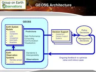
Architecture The structure of components, their relationships, and the principles and guidelines governing their design and evolution over time.
NEEDS • The GEOSS architecture describes how components fit together to produce an overall system capable of providing data and information that will better satisfy requirements than the individual components or systems of which it is composed. • The GEOSS architecture links together strategies and systems to facilitate Earth observations in a comprehensive, coordinated, and sustained manner.
GEOSS Challenges • Interoperability – what is it and how do we address it • Integration of Human factors – broader influence means more impacts • Dynamic participation • End to end integration – what does it mean?? • Multiple ownership/prioritization • SOSA understanding
Systems Uniformity of objectives Single corporate direction Cultural uniformity Common Technology Data standards and quality established Process for encouraging or enforcing participation GEOSS Disparate motivations Competing agendas Diverse backgrounds Varying technology levels Multiple views of data standards and quality Challenges
Interoperability Objective What few things must be the same so that everything else can be different?
GEOSS Architecture -Basic Standards and Services "The success of GEOSS will depend on data and information providers accepting and implementing a set of interoperability arrangements, including technical specifications for collecting, processing, storing, and disseminating shared data, metadata, and products." from GEOSS Implementation Plan, 5.3 Architecture and Interoperability
Canada Seattle WA Puget Sound Facts for Implementation (1/4) • Variety of users: governments, private sector, academic, science,… Users’ requirements and expectations vary a lot. • Users to be closely associated to any design and implementation process • Various communities with their own cultures: data & information providers / users with specific system interfaces & data formats, own ways of processing information, .. • No revolution imposed on work habits
Facts for Implementation (2/4) • Distributed System: Heterogeneous sets of world-wide distributed systems. Different technologies based on multitude of standards, proprietary solutions, … • No new single architecture imposed to everyone. , • Preserve the existing infrastructures as much as possible, • Simple and robust interfaces and formats (based on common, open, and widely used standards). • Progressive integration of thematic systems • Fusion of sources:Increasing user request for combined use of space and non-space data e.g. multi satellite missions with in-situ observation data
Facts for Implementation (3/4) • Dynamic, Open system:the SoS should be able to grow & attract third-party data & service providers and accept intermittent participation with disconnected/connected modes without disruption . • Comprehensive information flow: end to end - product order, planning, acquisition, processing, archiving and distribution – for data and information
Facts for Implementation (4/4) • User Interface: Increase demand from users for enhanced quality of geo-spatial data, information and services with more user-friendly, faster, easier and transparent access • Dependency between GEO tasks:risks that optimum solutions (technical, programmatic, data policy, ..) for a given task are sometimes incompatible across-tasks
Approach • Build upon existing systems and historical data, as well as existing documentation describing observational needs in various domains • The 10-year implementation plan must address cost effectiveness, technical feasibility and institutional feasibility • To be sustained over a long period of time, GEOSS needs to be adjustable, flexible, adaptable, and responsive to changing needs
Principles • Needs-driven - driven by user needs, supports a broad range of implementation options • Scope - addresses all observations required for participants to make products, forecasts and related decisions • Capabilities - includes observing, processing, and dissemination capabilities, provided by national, regional or international agencies subscribing to GEOSS while retaining their ownership and operational responsibility
Principles • Data and its exchange and dissemination - observations and products are to be observed, recorded and stored in clearly defined formats • Operation - secures the future continuity of observations • Catalogue - members and participating organizations and the components they support will be documented in a catalogue that is publicly accessible, network distributed, and interoperable with major Earth observations catalogues
Architecture and Interoperability Summary • Build a flexible architecture and Integration framework on a set of reusable components • Leverage existing external and internal standards, architectures, and models • Capture future capabilities through open architecture • Support wide range of business processes and environments • Enable disconnected/connected modes for all implementations • Integrate efforts for SoS development from distributed teams SOA is configurable and scalable to customer needs and leverages robust systems and processes for global interoperability