Download
1 / 12
120 likes | 138 Views
This article discusses the design and evolution of the GEOSS Information System, highlighting the priority actions, interoperability arrangements, and ongoing developments in the Architecture Implementation Pilot. It also emphasizes the integration of disciplines in GEOSS and the importance of standards and interoperability.

E N D
Vision and architecture ofGEOSS Information SystemGEOSS Design and Evolution George Percivall The Open Geospatial Consortium (OGC) GEO Task IN-05 coordinator 20 September 2013 ESA/ESRIN Frascati Italy
GEO Task IN-05GEOSS Design and Interoperability Priority Actions • GEOSS Information System research and prototyping • Societal Benefit Area needs drive development • Encourage systems to interoperate with GCI • Increase access to GEOSS Data-CORE • Coordinate with IN-03 GCI Evolution Recent Progress and Key Outputs for 2013 • Architecture Implementation Pilot (AIP) • Standards and Interoperability Forum (SIF) • GEOSS Future Products Workshop
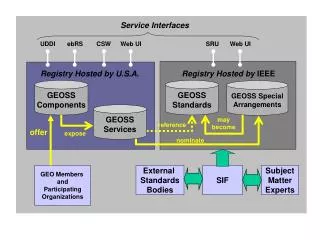
GEOSS Interoperability Arrangements- From the GEOSS 10 Year Plan Reference Document - • Interoperability through open interfaces • Interoperability specifications agreed to among contributing systems • Access to data and information through service interfaces • Open standards and intellectual property rights • GEOSS adopting standards; agreed upon by consensus, preference to formal international standards • GEOSS will not require commercial or proprietary standards • Multiple software implementations compliant with the open standards should exist • Goal is that at least one of the implementations should be available to all implementers "royalty-free"
Architecture Implementation Pilot (AIP) • Deploy and test new components for GCI and the broader GEOSS Information System • Agile, evolutionary development process • Sprints to identify architecture standards and improve maturity of components • AIP initiated in 2007; 5 previous phases completed • Deployed, test, demonstrated: GCI, Brokers, Community Portals, SBA Integrators, etc. • AIP-6 currently underway, delivery for Summit
AIP ResultsIntegration of disciplines thru architecture • Geo-informatics results… • Initial GCI prototypes • Brokering to span communities • Moving from “order” to “access” for rapid delivery • Fusing EO data with other geospatial information, • Sensor Web to hide complexity of diverse sensing systems and associated control structures. • Model Web vision promising with initial steps • …apply across SBAs: Disaster Management, Biodiversity Models, Energy, Water, Health
GEOSS AIP Architecture Community Objectives Enterprise Viewpoint GEOSS Vision and Targets Societal Benefit Areas System of Systems/ Interoperability Use Cases Services Information Framework Abstract/Best Practices Catalog/Registry Access and Order Processing Services Sensor Web User Identity Earth Observations Geographic Features Spatial Referencing Metadata and Quality GEOSS Data-CORE Information Viewpoint Computational Viewpoint Tutorials Optimized Design/Development Engineering Viewpoint Component Types Technology Viewpoint RM-ODP Viewpoints
Standards and Interoperability Forum (SIF) • Recent Achievements of SIF • Manage registry of standards & special arrangements • Interoperability Assessment Report with recommended metrics for GCI to monitor • Additional tutorials on GEOSS Best Practice Wiki • GEOSS Data-CORE metadata guidance document • 2013 Planned Deliverables of SIF • Additional Tutorials • Mime-types for helper applications in GCI • Quality metadata standards document to DSWG • Whitepapers on select interoperability topics
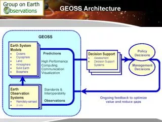
Policy Decisions GEOSS Future Products Workshop:Sensor Web and Model Web March 2013 • Earth System Models • Oceans • Ice • Land • Atmosphere • Solid Earth • Biosphere Decision Support AssessmentsDecision Support Systems Societal Benefits Interoperabilityand standards • Earth Observation Systems • Remotely-sensed • In situ On-going feedback to optimize value and reduce gaps
GEOSS Future Products WorkshopRecommendations • Products for GEOSS from Sensor Web and Model Web • Use methods of science to guide use of observations and predictions. • Utility of Sensor Web has been shown; development to meet remaining challenges. • Model Web vision should be advanced with a short-term plan • Interaction of Sensor Web and Model Web brings benefits beyond individual use • Address Diversity of GEOSS USERS • Further develop understanding of diversity of GEOSS Users • Authentication and Interoperability Issues advanced with support by SIF and AIP • Going beyond current state of GCI to meet expectations • GEOSS Capacity Building recommendations • Improve public messages for GEO full report posted https://portal.opengeospatial.org/files/?artifact_id=53993
Summary:Integration across disciplines in GEOSS • AIP development approach combines the best of prototyping and specifying • Architecture developed in AIP provides a basis to scale to multi-disciplinary needs in GEOSS. • Standards and interoperability arrangements support fusion of EO observations across disciplines • AIP and other GEO Tasks show the value of GEOSS in application of EO to meet societies needs
References • GEO • earthobservations.org • GEO Architecture Implementation Pilot • www.ogcnetwork.net/AIpilot • GEOSS registries and SIF • geossregistries.info • GEOSS Future Products Workshop www.ogcnetwork.net/node/1872