Discover Itasca County: Minnesota's Gem for Outdoor Recreation and Natural Wonders
300 likes | 416 Views
Itasca County, located in north-central Minnesota, boasts a population of approximately 43,000 and is the third-largest county in the state, spanning about 3,000 square miles with 1,000 lakes and numerous outdoor recreational opportunities. Visitors can enjoy activities such as skiing, camping, hiking, boating, hunting, and fishing, alongside an extensive network of snowmobile and ski trails. The county's diverse landscapes, shaped by glacial movements, provide a unique setting for exploring natural beauty. For more information, visit [Itasca County](http://www.co.itasca.mn.us/).

Discover Itasca County: Minnesota's Gem for Outdoor Recreation and Natural Wonders
E N D
Presentation Transcript
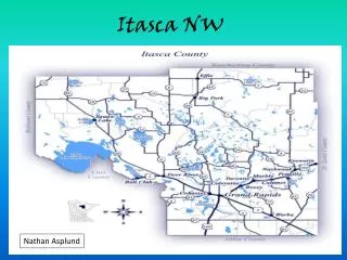
Itasca NW Nathan Asplund
Basic Information • Itasca County, with a population of approximately 43,000, is located in north central Minnesota. • The county is the third largest in the state, approximately 3,000 square miles. • There are 16 cities and 42 organized townships. • We have 1,000 lakes and over 1,000 miles of snowmobile and skiing trails. • Itasca County offers great outdoor recreational opportunities, including skiing, camping, hiking, boating, hunting and fishing. http://www.co.itasca.mn.us/
Climate and Temp • A climate is made up from the major air masses from western United States, Canada and the Mississippi River valley results in seasonal weather with major extremes in Itasca County. • Air masses moving north from the Mississippi River valley bring a large portion of the precipitation and humidity.
Rivers Oxbow lake Meandering river
Rivers cont. A meander is formed when the moving water in a river erodes the outer banks and widens its valley A U-shaped body of water formed when a wide meander from the main stream of a river is cut off to create a lake
How the landscapes were formed The Wadena Lobe advanced from the north several times. Its last advance deposited the Alexandria moraine (which was later reglaciated), the Itasca moraine, and the drumlin fields spanning Otter Tail, Wadena, and Todd counties. The Rainy and Superior Lobes came out of the northeast and advanced, sometimes with and sometimes independently of the Wadena. Its last advance left a coarse-textured till of basalts, gabbro, granite, iron formation, red sandstone, slate, and greenstone strewn across the northeastern half of Minnesota and as far south as the Twin Cities. The Des Moines Lobe originated in the northwest and advanced in a southeasterly direction across Minnesota and into Iowa. Its fine-textured till consisted of limestone, shale, and granite fragments, from which developed the fine prairie (now agricultural) soils found in these areas. Information from http://www.dnr.state.mn.us/snas/naturalhistory.html
Basic Geography of Itasca • Beach ridges • Melt water channel • Esker or esker-like ridge • Drumlin • Tunnel valley • Ice-walled lake plain • Fan
Beach ridges A beach ridge by Little Winnibigoshish lake In Itasca county Example of a beach ridge
Melt Water Channel Drainage channel cut by melt water possibly by glaciers
Eskers Sinuous ridge of interbedded sand, gravel, and silt; interpreted to have been deposited in an ice-walled channel or tunnel of a glacial melt water stream. Deposited by melt water of both the Koochiching and Rainy lobes, but drainage was generally to the south and east within the lobes.
Drumlin Oval or elongated hill believed to have been formed by the streamlined movement of glacial ice sheets across rock debris, or till
Ice-walled lake plain Ice-walled-lake plains form in the stagnant marginal zone of glacial Ice Sheets
POSTGLACIAL DEPOSITS • Eolian sand • Beach sediment • Alluvium • Peat • Terrace sediment
Eolian Sand Eolian sand—Fine-grained sand more than 5 feet (1.5 meters) thick that forms low-lying barchans dunes and sheet-sand deposits that display shallow depressions or blowouts. Interpreted to be windblown sand.
Beach Sediment Beach sediment—Sand and gravelly sand in low-rising terraces along the shores of Lake Winnibigoshish and other modern lakes. Interpreted as modern beach sediment; unit may include some ice push sediment from windblown lake ice.
Alluvium Alluvium—Interbedded fine-grained sand, fine-grained sandy loam, and silt loam; shells, wood, and other organic debris are typically present. Interpreted as the deposits of modern rivers during high-water stages.
Peat Peat—Organic material in various stages of decomposition; some deposits include small bodies of open water. Interpreted as swamp deposits and deposits of freshwater lakes that have filled with vegetation.
Terrance Sediment Terrace sediment—Sand and gravelly sand above the modern floodplain of the Big Fork River but located lower than the glacial-lake plain. Interpreted as representing the former level of the floodplain of the Big Fork River. The river has incised more deeply as the local base level has dropped over time.
Mylonite Zone Found exact locations by drilling
Overturned Fault Example
Folds Examples of folds
Works Cited • http://www.dnr.state.mn.us/snas/naturalhistory.html • http://www.co.itasca.mn.us/ • Google images • http://reflections.mndigital.org/cdm4/item_viewer.php?CISOROOT=%2Fmgs&CISOPTR=1164&DMSCALE=50.00000&DMWIDTH=800&DMHEIGHT=800&DMMODE=viewer&DMFULL=0&DMOLDSCALE=1.50000&DMX=0&DMY=0&DMTEXT=&DMTHUMB=1&REC=3&DMROTATE=0&x=112&y=50