Download
1 / 1
10 likes | 159 Views
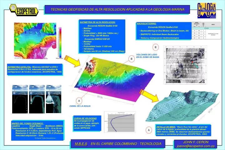
TECNICAS GEOFISICAS DE ALTA RESOLUCION APLICADAS A LA GEOLOGIA MARINA. BATIMETRIA DE ALTA RESOLUCION: Ecosonda RESON SeaBat 8160 Multihaz 50 KHz Profundidad < 3000 mts (1800m rec.) Single Ping, 126 HR Beans Ecosonda SIMRAD EM12D Multihaz 13 KHz

E N D
TECNICAS GEOFISICAS DE ALTA RESOLUCION APLICADAS A LA GEOLOGIA MARINA • BATIMETRIA DE ALTA RESOLUCION: • Ecosonda RESON SeaBat 8160 • Multihaz • 50 KHz • Profundidad < 3000 mts (1800m rec.) • Single Ping, 126 HR Beans • Ecosonda SIMRAD EM12D • Multihaz • 13 KHz • Profundidad hasta 11.000 mts • 162 beams • Sample rate 60 cm (Shallow) 240 cm (Deep) • BACKSCATTERING: • Ecosonda RESON SeaBat 8160 • Backscattering en Dos Modos ( Beam to beam, All) • SNIPPETS: Individual Beam Backscatter • Textura y Composición Sedimentológica B VOLCANES DE LODO EN EL DOMO DE BAHIA B BATIMETRIA SATELITAL: Misiones GEOSAT & ERS-1 Resolucion 2 Km x 2 Km, adecuada para estudios de configuracion de fondos oceanicos. (ECOPETROL, 1999) 270 Km 370 Km A CANAL DE LA AGUJA 35 Km CURVA DE VELOCIDAD De la propagacion de ondas en el agua, ejemplo de la zona Caribe, utili - zando SIPPICAN. • MAPEO DEL FONDO OCEANICO: • Leadline - Single Beam - Multibeam (MBES). • Posicionaimento: GPS < 2 meters; RTK - 10 to 20 cm • Resolucion X-Y 5-25cm, dependiendo Prof. Agua • Resolucion Z: 20-50cm (Somera) 1.5% Z (Profunda) • Velocidad adquisicion ~ 9 kts • (Cortesia Thales Geosolutions.) DETALLE DE MBES: “Basin floor fan delta”, al pie del cañon de la Aguja, profundidad de la planicie abisal: 3800 metros (BNM). Se observan deslizamientos gravita - cionales y corrientes profundas. (ECOPETROL, 2002) A M.B.E.S EN EL CARIBE COLOMBIANO : TECNOLOGIA JOHN F. CERON jceron@ecopetrol.com.co