Download
1 / 20
200 likes | 399 Views
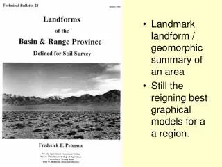
Landmark landform / geomorphic summary of an area Still the reigning best graphical models for a a region. ( adapted from Peterson, 1981 ; Fig. 1 ). F - basin floor (LS) (= bolson floor) P - piedmont slope (LS). ( adapted from Peterson, 1981 ; Fig. 2 ).

E N D
Landmark landform / geomorphic summary of an area • Still the reigning best graphical models for a a region.
F- basin floor(LS) (= bolson floor) P- piedmont slope(LS) ( adapted from Peterson, 1981; Fig. 2 )
Basic Landform elements of Basin & Range terrain – southwestern US Landscape : bolson, semi-bolson A - alluvial fan B - ballenas F - alluvial flat M - mountains (LS) P- fan piedmeont (LS) S - fan skirt Y - playa ( adapted from Peterson, 1981; Fig. 3 )
Generalized landscape model for bolsons in US Basin & Range.
Drainageway Types . 1 - interfan - valley drainageway 2 - fanhead trench 3 - onfan drainageway 4 - interfan-valley drainageway ( with on-fan tributaries ) A - alluvial fan V - interfan valley P - fan piedmont ( adapted from Peterson, 1981; Fig. 7 )
F - fan remnant - eroded fan remnant sideslope I - inset fan ( adapted from Peterson, 1981; Fig. 4 )
B - ballena I - inset fan P - fan piedmont (LS) ( adapted from Peterson, 1981; Fig. 6 )
Schoeneberger LS: badlands LF: ballenas, ballonsBadlands, SD
Common, Progressive Sequence of : dissection, alluviation, redissection, realluviation Time: a - ( relict surface remnants with young eroded sideslopes ) b - pediment ( footslope ) c - inset fan d- (inset-fan remnants) e - younger inset-fan surface ( adapted from Peterson, 1981; Fig. 8 )
A - fan apron BF - basin floor P - fan piedmont ( adapted from Peterson, 1981; Fig. 10 )
Landscape Evolution : Typical Erosion Sequences of Fan Piedmonts 1 - original fan surface 2 - first gullying sequence ( or its remnants of pediments, footslopes ) 3 - second gullying sequence ( or its remnants of pediments, footslopes ) 4 - third gullying sequence ( or its remnants of pediments, footslopes ) Generalized (Erosional) Evolution of Divides a – relict fan-piedmont surface (1) b - asymmetric, relict fan piedmont surface and new, encroaching pediments c - ridgeline remnants of pediments 2 & 3 d - late stage erosion of “c” ( adapted from Peterson, 1981; Fig 11 )
BF - basin floor I - inset fan P - (dissected) fan piedmont S - fan skirt ( adapted from Peterson, 1981; Fig. 12 )
Landscape : semi-bolson B - ballenas F - (axial stream) flood plain I - inset fans M - mountains (LS) P - fan piedmont ( and eroded fan remnants ) S - fan skirts T - (axial) stream terrace ( adapted from Peterson, 1981; Fig. 13 )
Hillslope Evolution : backwearing side slopes and pedimentation stream Time: 0 S = stable summit a = base level P = pediment ( = erosional surface ) ps = pedisediment ( adapted from Peterson, 1981; Fig. 16 )
Hillslope Evolution & Hillslope - Profile Positions: summit (divide) lowering begins - 2 dimensional - backwearing slope convergence - divide lowering ( adapted from Peterson, 1981; Fig. 15 )
Variations of hillslope-profile positions in southwestern US Landscapes C S N B S I N c = crest m = summit b = backslope f = footslope t = toeslope x = drainageway ( adapted from Peterson, 1981; Fig. 17 ) I= interfluve C = crest S = side slope H = head slope N = nose slope B = base slope 2 dimensional hillslope-profile positions vs. 3 dimensional geomorphic components