Download
1 / 31
310 likes | 423 Views
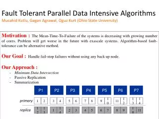
This project aims to enhance aviation model performance for accurate forecasting. It includes real-time and retrospective analysis, latency reduction, dual-computer availability, and improved convective storm predictions. The website provides feedback and hourly outputs for various forecast fields. The project also focuses on reducing model latency and optimizing convective forecasts through radar data assimilation. Future milestones involve HRRR and RAP model improvements, ensuring timely and reliable aviation forecasts.

E N D
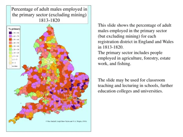
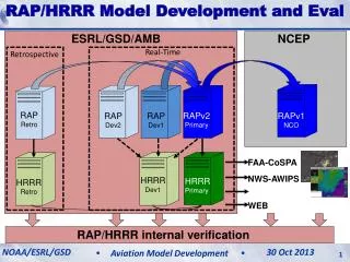
RAP/HRRR Model Development and Eval HRRR (and RAP) Future Milestones HRRR Milestones ESRL/GSD/AMB NCEP Real-Time Retrospective RAP Retro RAPv2 Primary RAP Dev2 RAP Dev1 RAPv1 NCO FAA-CoSPA NWS-AWIPS HRRR Dev1 HRRR Primary HRRR Retro WEB RAP/HRRR internal verification NOAA/ESRL/GSD FPAW - 2013 RAP/HRRR Model Status 30 Oct 2013 24 October 2013 Aviation Model Development 1
HRRR Availability – getting it out HRRR (and RAP) Future Milestones HRRR Milestones HRRR 12 hr fcstavailability Includes all missed/incomplete runs CoSPA Evaluation Periods Development and Upgrade Periods 3 month running average NOAA/ESRL/GSD FPAW - 2013 RAP/HRRR Model Status 30 Oct 2013 24 October 2013 Aviation Model Development 2
HRRR Dual-Computer Availability HRRR (and RAP) Future Milestones HRRR Milestones HRRR 12 hr fcstavailability Includes all missed/incomplete runs Jet (HRRR primary) Zeus (HRRR backup) Jet or Zeus (union) NOAA/ESRL/GSD FPAW - 2013 RAP/HRRR Model Status 30 Oct 2013 24 October 2013 Aviation Model Development 3
HRRR Dual-Computer Availability HRRR (and RAP) Future Milestones HRRR Milestones HRRR 12 hr fcstavailability Excludes two (or fewer) consecutive missed/incomplete runs Jet (HRRR primary) Zeus (HRRR backup) Jet or Zeus (union) NOAA/ESRL/GSD FPAW - 2013 RAP/HRRR Model Status 30 Oct 2013 24 October 2013 Aviation Model Development 4
HRRR Aviation Websites HRRR (and RAP) Future Milestones HRRR Milestones http://rapidrefresh.noaa.gov/hrrraviation/ (hourly output) Feedback from AWC Aviation specific forecast fields: Convection(intensity and depth) Ceiling and Visibility Flight Rules Surface Wind Precip Type Snowfall http://rapidrefresh.noaa.gov/hrrraviation15min/ (sub-hourly output) NOAA/ESRL/GSD FPAW - 2013 RAP/HRRR Model Status 30 Oct 2013 24 October 2013 Aviation Model Development 5
HRRR Latency – getting it out fast HRRR (and RAP) Future Milestones HRRR Milestones 2013 HRRR changes permitted ~45 min reduction in latency CoSPAperiod CoSPAperiod 2012 CoSPA period 2013 CoSPA period +1:45 +2:30 CoSPA Evaluation Periods Development and Upgrade Periods 3 month running average FPAW - 2013 NOAA/ESRL/GSD RAP/HRRR Model Status 24 October 2013 30 Oct 2013 Aviation Model Development 6
2012HRRRInitialization from RAP 13z 14z 15z 13 km RAP Obs Obs Obs GSI 3D-VAR GSI 3D-VAR GSI 3D-VAR HM Obs HM Obs HM Obs GSI HM Anx GSI HM Anx GSI HM Anx 1 hr fcst 1 hr fcst Refl Obs Refl Obs Refl Obs Digital Filter Digital Filter Digital Filter 18 hr fcst 18 hr fcst 18 hr fcst 3-km Interp 3-km Interp 3-km Interp 3 km HRRR 15 hr fcst 15 hr fcst 15 hr fcst
2013HRRRInitialization from RAP 13 km RAP 13z 14z 15z GFS Ens GFS Ens GFS Ens Obs Obs Obs GSI Hybrid GSI Hybrid GSI Hybrid HM Obs HM Obs HM Obs GSI HM Anx GSI HM Anx GSI HM Anx 1 hr fcst 1 hr fcst Refl Obs Refl Obs Refl Obs Digital Filter Digital Filter Digital Filter 18 hr fcst 18 hr fcst 18 hr fcst Obs 1 hr pre-fcst 3-km Interp GSI 3D-VAR 3 km HRRR 45 min of reduced latency HMObs GSI HM Anx Refl Obs 15 hr fcst
3-km radar data assimilation: Eliminating the spin-up problem Radar Obs 05:00z 18 May 2013 05z + 0 min 0-hr fcst3-km radar DA 0-hr fcstNO 3-km radar DA
Improved 0-2 hr Convective Fcsts Radar Obs 05:15z 18 May 2013 05z + 15 min 15-min fcst3-km radar DA 15-min fcstNO 3-km radar DA FPAW - 2013 NOAA/ESRL/GSD RAP/HRRR Model Status 24 October 2013 30 Oct 2013 Aviation Model Development 10
Improved 0-2 hr Convective Fcsts Radar Obs 05:30z 18 May 2013 05z + 30 min 30-min fcst3-km radar DA 30-min fcstNO 3-km radar DA FPAW - 2013 NOAA/ESRL/GSD RAP/HRRR Model Status 24 October 2013 30 Oct 2013 Aviation Model Development 11
Improved 0-2 hr Convective Fcsts Radar Obs 05:45z 18 May 2013 05z + 45 min 45-min fcst3-km radar DA 45-min fcstNO 3-km radar DA FPAW - 2013 NOAA/ESRL/GSD RAP/HRRR Model Status 24 October 2013 30 Oct 2013 Aviation Model Development 12
Improved 0-2 hr Convective Fcsts Radar Obs 06:00z 18 May 2013 05z + 1 hour 1-hr fcst3-km radar DA 1-hr fcstNO 3-km radar DA FPAW - 2013 NOAA/ESRL/GSD RAP/HRRR Model Status 24 October 2013 30 Oct 2013 Aviation Model Development 13
Improved 0-2 hr Convective Fcsts Radar Obs 06:30z 18 May 2013 05z + 1:30 min 1-hr 30m fcst3-km radar DA 1-hr 30m fcstNO 3-km radar DA FPAW - 2013 RAP/HRRR Model Status 24 October 2013 NOAA/ESRL/GSD 30 Oct 2013 Aviation Model Development 14
Improved 0-2 hr Convective Fcsts Radar Obs 07:00z 18 May 2013 05z + 2hr min 2-hr fcst3-km radar DA 2-hr fcstNO 3-km radar DA FPAW - 2013 RAP/HRRR Model Status 24 October 2013
Improved 0-2 hr Convective Fcsts Radar Obs 08:00z 18 May 2013 05z + 3hr 3-hr fcst3-km radar DA 3-hr fcstNO 3-km radar DA FPAW - 2013 RAP/HRRR Model Status 24 October 2013
Continued HRRR Improvement in 2013 HRRR (and RAP) Future Milestones HRRR Milestones Critical Success Index (CSI) skill score Verification June 1- Sept. 30 (respective seasons) 2013 HRRR 2012 HRRR
HRRR use in CoSPA HRRR (and RAP) Future Milestones HRRR Milestones CoSPA: Collaborative effort: ESRL/GSD, NCAR/RAL, MIT/LL Provide 0-8 hr thunderstorm intensity and echo top guidance to aviation community HRRR15 UTC 08 July 2011 6 hr forecast valid 21 UTC CoSPA17 UTC 08 July 2011 4 hr forecast valid 21 UTC Observation Valid 21 UTC 08 July 2011 VIL Blend with CIWS Echo Top FPAW - 2013 RAP/HRRR Model Status 24 October 2013
Time-lagged Ensemble Forecasts valid 21-22z 27 April 2011 Forecasts valid 22-23z 27 April 2011 10-11 hr fcst 11-12 hr fcst HRRR 11z Init 09-10 hr fcst 10-11 hr fcst HRRR 12z Init 08-09 hr fcst 09-10 hr fcst HRRR 13z Init Spatial radius 45 km Time radius 1 hr UH threshold 25 m2/s2 All six forecasts combined to form probabilities valid 22z 27 April 2011
Example: 28 August 2013 Convection develops in NYC terminal areas around 16 UTC FPAW - 2013 RAP/HRRR Model Status 24 October 2013
HRRR Conv Prob Fcst (HCPF) 02 hr fcst valid 16z 28 Aug 2013 Convective coverage now over much of extreme E PA and NJ Probability exceeds 40% Obsvalid 16z 28 Aug 2013 FPAW - 2013 RAP/HRRR Model Status 24 October 2013
Aviation hazard forecasts – all based on RAP and HRRR models (out to 15-18h) Hourly updated 13km Rapid Refresh model forecasts (development supported by FAA/MDE, NOAA) Refreshing from latest observations every hour gives better accuracy
HRRR Transition to NCEP • 2013 - early 2014 – 2 computers running identical HRRR (and RAPv2) – interim solution • Boulder – computer 1 • Fairmont, WV – computer 2 • Expected reliability at 98.5-99% via coordination of downtimes for Boulder vs. Fairmont computers • 2014 – NCEP running RAPv2 (FYQ1) and HRRR (FYQ2) • RAPv2 running in NCEP/NCO testing now • Effort underway to begin testing HRRR at NCEP FPAW - 2013 RAP/HRRR Model Status 24 October 2013
NCEP ESRL
Forecast NOAA’s Current NWP Model Production Suite Oceans HYCOM WaveWatch III Climate CFS Coupled Hurricane GFDL HWRF MOM3 ~2B Obs/Day Mostly Satellite +Radar Dispersion ARL’s HYSPLIT North American Mesoscale WRF NMM Global Forecast System Global Data Assimilation Severe Weather WRF NMM WRF ARW Short-Range Ensemble Forecast North American Ensemble Forecast System WRF: NMM+ARW ETA, RSM Air Quality GFS, Canadian Global Model NAM+CMAQ Rapid Refresh for Aviation, Severe Weather, Energy NCEP overview
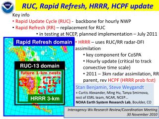
History – NCEP (NMC) Implementations of FAA-funded high-frequency models with aviation focus • 1994 First operational implementation of RUC • 60km resolution, 3-h cycle • 1998 40km resolution, 1-h cycle, • Cloud physics, land-surface model • 2002 20km resolution • GOES cloud data assimilation • 2003 Change to 3dVAR analysis for improved assimilation • 2005 13km resolution New observation types (METAR cloud, GPS-PW, new cloud physics) • 2008Assimof radar reflectivity, mesonet winds, • 2012 WRF/GSI-based Rapid Refresh (RAP) replaced RUC • 2013 (Dec) RAP version 2 – improved storm environment • 2014 (Mar) HRRR version 1 – 3km
Weather Model Development for Aviation Obs radar 21z Sept 16 2010 • development of the Rapid Refresh (RAP) and HRRR models • application of HRRR and RAP to aviation applications • hourly data assimilation of latest observations to initialize the RAP and HRRR • Implementation of RAP and HRRR to NOAA operational models at NCEP • inter-lab/center interactions • Development - NCAR, MIT/LL, U. Oklahoma, NCEP • Operational evaluation - NWS Regions/Offices, AWC, SPC, HPC, FAA • Implementation – NCEP (EMC, NCO) 08z+13h HRRR Valid 21z
Weather Model Development for Aviation Obs radar 21z Sept 16 2010 • inter-lab/center interactions • Development – • NCAR, • MIT/LL • U. Oklahoma • NCEP (National Centers for Environmental Prediction – within NWS/NOAA) • Operational evaluation • NWS Regions (Eastern, Central, Southern, Western, Alaska) • NWS Forecast Offices (~125 of them) • Aviation Weather Center, Kansas City, MO • Storm Prediction Center, Norman, OK • FAA • Implementation – NCEP (EMC, NCO) at NOAA/National Weather Service 08z+13h HRRR Valid 21z
Purpose of FAA Model Development and Enhancement (MDE) Team • Improve accuracy of hourly updated weather models, needed especially for increasing aviation requirements. • NOAA Research (GSD) leads and coordinates MDE project with other labs -- NCAR, NOAA operations (NWS, NCEP), universities, MIT/Lincoln Labs • Steady improvement in weather model guidance is critical to meet future requirements for National Air Space in NextGen era. MDE Product Development Team is the focal point for this effort (along with NOAA operations). NOAA/ESRL/GSD 12 July 2012 Aviation Model Development
Key Advantage of 3-km HRRR HRRR (and RAP) Future Milestones HRRR Milestones 13-km 6hr forecast HRRR 6hr forecast 13-km Resolution Parameterized Convection 3-km Resolution Explicit Convection 07 June 2012 ACCURATE STORM STRUCTURE ACCURATE ESTIMATEOF PERMABILITY NO STORM STRUCTURE NO ESTIMATE OF PERMEABILITY 5 PM EDT observed FPAW - 2013 RAP/HRRR Model Status 24 October 2013
Take-home Messages • NOAA HRRR/RAP weather model grids are the backbone for most aviation hazard guidance products for 1-18h duration, including • G2G-turbulence, • FIP-icing • Upper-level winds • Ceiling/visibility • Terminal forecasts • Improvements dependent on transforming increases in atmospheric scientific understanding and computer resources • Sustained FAA support has given substantial improvement to US aviation weather guidance