Download
1 / 41
440 likes | 719 Views
Objective: Identify and describe how has the geography of Africa influenced the lifestyle of Africans? Warm up: State at least three things that you know about the country of Africa. How do you think geography influenced the way people live in Africa. Two things you would like to learn.

E N D
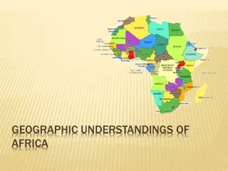
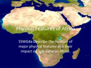
Objective: Identify and describe how has the geography of Africa influenced the lifestyle of Africans? Warm up: State at least three things that you know about the country of Africa. How do you think geography influenced the way people live in Africa. Two things you would like to learn. Geographic Features of Africa
Based on the map… • What can you tell about the Northern Region, Central Region and Southern region of Africa? • What about the Coastal area?
Africa’s Size 4 6 0 0 M I L E S 5000 MILES • Second largest continent 11,700,000 sq. mi. • 10% of the world’s population. • 2 ½ times the size of the U. S.
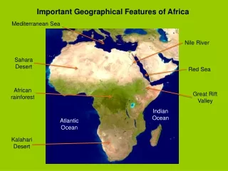
Mediterranean Sea Bodies Of Water Red Sea NileRiver NigerRiver L. Chad--> <--Gulf of Aden L. Albert--> Congo River L. Victoria L. Tanganyika-> Indian Ocean Atlantic Ocean Zambezi River LimpopoRiver OrangeRiver Pacific Ocean
The Congo River Basin • Covers 12% of thecontinent. • Extends over 9countries. • 2,720 miles long. • 99% of the countryof Zaire is in theCongo River basin.
The Niger River Basin • Covers 7.5% of the continent. • Extends over 10 countries. • 2,600 miles long.
Atlas Mts. Mountains & Peaks Δ Mt. Kenya Δ Mt. Kilimanjaro Ruwenzori Mts. Drajensburg Mts.
Libyan Desert Deserts Sahara Desert Sahel Namib Desert Kalahari Desert
Interesting Facts • Sahara desert is the second largest desert in the world, after Antarctica, and the largest hot desert in the world. • The desert extensively covers almost all the parts of Northern Africa. • Sahara desert receives only 8 inches of rainfall per year • It stretches from the Red Sea and includes parts of the Mediterranean coasts to the outskirts of the Atlantic Ocean. In the southward region, it is limited by the Sahel
Definition.. • Desertification is the degradation of land in drylands.[2] Caused by a variety of factors, such as climate change and human activities, desertification is one of the most significant global environmental problems.[3]
Warm-ups Week of 10/ • What is desertification and how has it impacted Africa? • How are rifts formed ? 10/ • PSAT Day 10/ • What is the difference between the Sahara and the Sahel 10/
Desertification has its greatest impact in Africa. • Two thirds of the continent is desert or drylands. • There are extensive agricultural drylands, almost three quarters of which are already degraded to some degree. • The region is afflicted by frequent and severe droughts. Many African countries are landlocked, have widespread poverty, need external assistance, and depend heavily on natural resources for subsistence”.
They have difficult socio-economic conditions, • insufficient institutional and legal frameworks, • incomplete infrastructure, • weak scientific, technical, and educational capacities. • African countries have had to convince the international community of the need to Combat Desertification in Countries Experiencing Serious Drought and/or Desertification, Particularly in Africa
The Sahel • Located In the southward region, • The Sahara is limited by the Sahel, a belt of semi-arid tropical savanna separating it from Sub-Saharan Africa. • Timbuktu. Djenné. Koumbi Saleh. For centuries, the Sahel boasted some of Africa's most influential civilizations. A narrow band of semi-arid land south of the Sahara.
the Sahel attracted both Arabs looking for gold from Sudan and Europeans looking for slaves from West Africa. • The two influences merged with native ones, creating a culturally complex area. The Sahel is widely French-speaking, Islamic and takes its name ("shore") from Arabic.
The region, one of the poorest and most environmentally damaged places on earth, has deep troubles. In the 1970s, the Sahel captured international attention when drought and famine killed nearly 200,000 people.
Valleys & Plains Great Rift Valley
Great Rift • 6,000-mile crack (fissure) in the earth's crust, stretching from Lebanon to Mozambique. • One of its most dramatic sections slices through East Africa, dividing Kenya into two segments. • Geologists know that the Rift Valley was formed by violent subterranean forces that tore apart the earth's crust. These forces caused huge chunks of the crust to sink.
between parallel fault lines and force up molten rock in volcanic eruptions. Evidence that this process, called rifting, is still in progress comes from the many active and semi-active volcanoes, located along the Rift. Evidence of volcanic activity along the rift is provided by the presence of numerous boiling hot springs
Great Rift Valley 3,000 miles long
Tropic of Cancer 20° N Africa:The“Tropical”Continent Equator 0° Tropic of Capricorn20° S
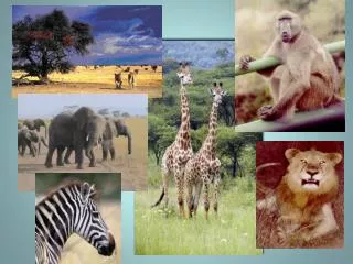
African Savannah:13 million sq. mi. • Of Africa's great plains regions, the Serengeti is the most famous. • Straddling Kenya and Tanzania, it is the only part of Africa where vast, annual migrations of animals -- wildebeest and zebras -- still occur. • Early man first appeared in the Serengeti region's Olduvai Gorge some 2 million years ago
Today, the plains boast a wide range of cultures, from Maasai nomads to Kikuyu farmers and Dorobo hunter-gatherers. For thousands of years, the region's rhythm of life remained unchanged. But now, sporadic droughts, soil erosion and overgrazing are tiring the land out, while demands on it from impoverished human populations continue to grow.
African Rain Forest • Annual rainfall of up to 17 ft. • Rapid decomposition (very humid). • Covers 37 countries. • 15% of the land surface of Africa.
Kilimanjaro, with its three volcanic cones, Kibo, Mawenzi, and Shira, is a dormant volcano in Tanzania and the highest mountain in Africa at 5,895 metres or 19,341 feet above sea level
Mediterranean Sea Atlas Mts. Libyan Desert The Complete Topography Of AFRICA Tropic of Cancer 20° N Sahara Desert Red Sea Sahel NileRiver NigerRiver L. Chad--> Great Rift Valley <--Gulf of Aden L. Albert--> Δ Mt. Kenya Equator 0° Congo River L. Victoria Δ Mt. Kilimanjaro L. Tanganyika-> Indian Ocean Ruwenzori Mts. Atlantic Ocean Zambezi River Namib Desert Kalahari Desert LimpopoRiver Tropic of Capricorn20° S OrangeRiver Drajensburg Mts. Pacific Ocean
Activity • Using your desk top map, fill in the geographic features of Africa.