Download

1 / 8
80 likes | 205 Views
Explore the importance of major river systems and mountains like the Himalayas, Hindu Kush, Western Ghats, and Eastern Ghats in ancient Indian civilization.

E N D
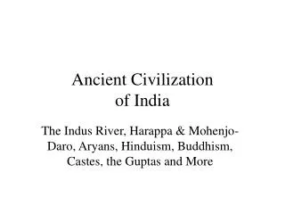
Geographic Features Of Ancient India By Veronica Sedano
The major river systems of India were extremely important to the rise of civilization in this region. The eastern, western Ghats, Hindu Kush Mountains, and Himalaya Mountains were important because that is where most of the water came from in the form of snow or rain. One of the major river systems of India is the Ganges River. Another one of the major river systems is the Brahmaputra River. The last one is the Indus River. Mountains are very important because it’s where snow melts and rain falls which goes down to the river that flows through there. The Himalaya Mountains are located aside by India’s northern border. “The Himalayas live up to their name, which means “home of snows.” (Frey 127). It can get up to 10 feet of snow at one time, and below the mountains the earth is always moving which causes earthquakes or landslides. The Hindu Kush Mountains are another important source of water. The mountains form a barrier between India and preset day Afghanistan and some of its peaks can reach up to 5 miles high. “The
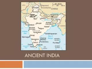
Khyber Pass is a 28-mile-long gap between the mountains.”(Frey 129) It connects central Asia through the Indian Subcontinent. The Western Ghats are higher than the Eastern Ghats. They have steep slopes, narrow valleys, heavy rainfalls, and hardwood forests. Since the climate there is wet it encourages the growth of tropical plants. The Eastern Ghats are not as wet as the Western Ghats. A lot of rivers flow in between and have many hardwood trees. These rivers rarely flood and are not safe for travel. Lastly, they are near the Deccan Plateau. This picture shows where the Eastern and Western Ghats were located. Pg.127. This map shows the Deccan Plateu. Pg.125
The Ganges River is one of the major river systems of India. Which were really important to the rise of civilization in this region because people used it to grow crops. This river starts at the Himalaya Mountains and flows across most of northern India. It comes down through ice, rocks, and valleys. “The river carries sediment (bits of earth and sand) from the Himalayas to the northern plains.”(Frey 126). It has a very good water supply from melting ice. Since it leaves sediment behind it creates some of the best fertile farmland up in the northern plains. When it’s the rainy season, the river will sometimes flood and could destroy crops planted around the banks. The Narmada River is in central India and is the fifth largest river in India. It flows westward India over a length of 1,312 kilometers before it enters Khambat. It is one of only three major rivers in the peninsular on India along with the Tapti and the Mahi River.
Another of the major river systems of India is the Brahmaputra River. The river is up in the Himalaya Mountains. It flows down to the valleys and gets deeper and slower. Then eventually, the river meets another river, which is the Ganges River, and where they meet is a good place to farm. The last river that's a major river system of India is the Indus River. This river is 3,180 kilometers (1,976 miles) in length and is the third largest river of annual flow on the Indian Subcontinent. This river gets its water by the snows and glaciers of the Himalayas and the Hindu Kush Mountains. The flow of the water is determined by seasons. In winter it diminishes greatly and it floods the banks in the monsoon months from July to September. This is the Brahmaputra River. pg.124
These are the main reasons to the rise of civilization in this region. First, the mountains which were the Himalaya mountains, Hindu Kush Mountains, Western Ghats, and the Eastern Ghats. They were important because they provided the water from melted snow and rain. Second, the Ganges River that flows across most of northern India and flows into the ocean. Which carried that sediment good for soil and planting crops near the river. Third, the Brahmaputra River that flows down from the Himalayas to where it meets the Ganges River people would settle right there. Where they meet is good to grow crops. Lastly, is the Indus River. It gets the water supply from the Himalayas and the Hindu Kush Mountains.
Works Cited 1.Frey, Wendy. History Alive! The Ancient World. Palo Alto, CA.2004.TCI
Author’s Page Hello. My name is Veronica. I’m 11 years old. I was born in Watsonville, California and live in Santa Cruz, California. When I have free time I like to hang out with my friends. I like to go to the beach a lot and jump over small waves and walk on the beach. After, I like going to the arcade and play mini golf or laser tag with my friends. I usually beat them. My two favorite movies are Twilight and Finding Nemo. My favorite book series is the Twilight series. I also like going to the movies with my friends. My favorite ice cream flavors are chocolate, vanilla, and strawberry. I like getting ice cream from Coldstone in downtown.