Download
1 / 97
970 likes | 1.17k Views
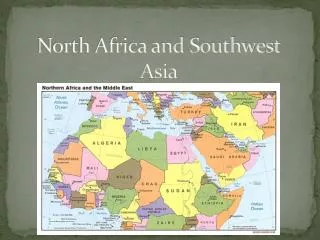
North Africa and Southwest Asia. WGEOG92Y. The Middle East: Essential Questions. LOCATION: How has location affected the peoples of the Middle East? PLACE: How has the environment shaped the people of the Middle East? What religious ideas began and are associated with the region?

E N D
North Africa and Southwest Asia WGEOG92Y
The Middle East: Essential Questions • LOCATION: How has location affected the peoples of the Middle East? • PLACE: How has the environment shaped the people of the Middle East? • What religious ideas began and are associated with the region? • How did Imperialism and Nationalism affect the region?
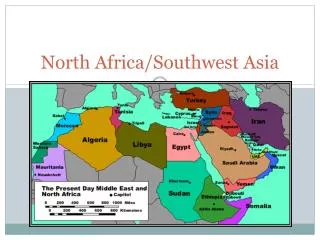
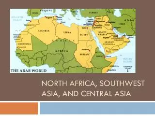
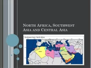
Section 2 North Africa • • The Nile River valley and ancient Egypt, one of the world’s great civilizations, formed a cultural hearth. • North Africa shares the Arabic language and the Islamic religion and culture with Southwest Asia. NEXT
North Africa Roots of Civilization in North Africa North African Countries • Algeria, Egypt, Libya, Morocco, Sudan, Tunisia Egypt Blossoms Along the Nile • Nile’s flooding provides water, rich soil, to help civilization grow • Nile villages united into first Egyptian dynasty around 3100 B.C. - Pharaohs rule Egypt for 2,600 years • Egyptian geometry and medicine are spread by trade Carthage • Legend says great ancient city of Carthage was founded in 814 B.C. - location on Gulf of Tunis peninsula make it a trade center Continued . . . NEXT
continuedRoots of Civilization in North Africa Islam in North Africa • Over time, invaded by Greeks, Romans, Phoenicians, Ottoman Turks • Islam is main cultural, religious influence - monotheistic religion based on Muhammad’s teachings • Southwest Asian Muslims invade North Africa in A.D. 632 - take Egypt in 634; control whole region by 750 • Muslims bind territory with sea-linked trade zones NEXT
Economics of Oil Black Gold • Oil has replaced cash crops, mining as economic base - transformed economies of Algeria, Libya, Tunisia • Oil also causes problems - Libya’s workforce lacks training, education to work in oil industry - high-paying oil jobs go to foreign workers - despite oil, unemployment remains high - Libyan workers migrate to Europe for jobs NEXT
A Culture of Markets and Music North African Souks • Souks (marketplaces) are located in the medina (old section of town) - best are in Marrakesh, Morocco - high-pressure sales and fierce bargaining over clothes, spices, food Protest Music • Rai—fast-paced Algerian music is developed in 1920s by urban youth - before independence in 1962, rai expresses anger at French colonizers - today, rai is criticized by Islamic fundamentalists for Western style - rai now a form of rebellion against Islamic fundamentalists NEXT
Changing Roles of Women Women and the Family • Homes are centered around males, few women work after marriage • Women’s roles are changing, especially in Tunisia - multiple wives are prohibited; both spouses can seek divorces - high spouse-abuse penalties; no more arranged marriages for young girls • More women have professional jobs, with equal pay for equal jobs - hold 7% of Tunisian parliamentary seats - manage 9% of businesses in Tunis, Tunisia’s capital NEXT
Physical Geography of Southwest Asia: Harsh and Arid Lands Southwest Asia’s land is mostly arid or desert. The region is defined by the resource it lacks—water, and the one it has in abundance—oil. Sandstone near Wadi Madakhil, Saudi Arabia. NEXT
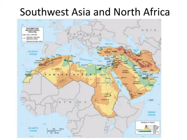
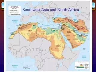
The Middle East • Also known as Southwest Asia. • “Crossroads of the World” • Consists of Southwest Asia, Southeast Europe and Northern Africa. • River Valley’s • Nile • Tigris-Euphrates • Mesopotamia
The Middle East • Deserts: • Sahara • Arabian • Rub’ al Khali or “Empty Quarter” • Mountains: • Atlas (Morocco) • Pontic and Taurus (Turkey) • Elburz and Zagros (Iran)
The Middle East • Northern Tier: • Plateau of Iran • Plateau of Anatolia • Arabian Peninsula • Fertile Crescent? • “Fertile Fish-hook” • “Breadbasket in the Desert”
Section 1 Landforms and Resources • The Southwest Asian landforms have had a major impact on movement in the region. • The most valuable resources in Southwest Asia are oil and water. NEXT
Landforms and Resources Landforms Divide the Region Shifting Plates • Southwest Asia forms a land bridge between Asia, Africa, Europe • Region is at edge of a huge tectonic plate - parts of Arabian Peninsula are pulling away from Africa - parts of Anatolian Peninsula are sliding past parts of Asia - other plates are pushing up mountains in other parts of Asia Continued . . . NEXT
continuedLandforms Divide the Region Peninsulas and Waterways • Arabian Peninsula lies between Red Sea and Persian Gulf • Red Sea covers a rift valley created by Arabian plate movement • Zagros, Elburz, Taurus mountains at north side cut off part of region • Anatolian Peninsula (Turkey) is between Black and Mediterranean seas • Strategic waterways include Suez Canal from Red Sea to Mediterranean - Bosporus and Dardenelles straits connect to Russia, Asia Continued . . . NEXT
continuedLandforms Divide the Region Plains and Highlands • Arabian Peninsula is covered by dry, sandy, windy plains - wadis—riverbeds that are dry except in rainy season • Iran has stony, salty, sandy desert plateau surrounded by mountains • Anatolian Peninsula is plateau with some agriculture, grazing • Afghanistan’s Northern Plain is farming area surrounded by mountains • Golan Heights(Al Jawlan)—plateau near Jordan River, Sea of Galilee - site of conflict due to strategic location Continued . . . NEXT
continuedLandforms Divide the Region Mountains • Afghanistan’s Hindu Kush Mountains help frame southern Asia - country is isolated by its landlocked, mountainous terrain • Iran’s Zagros Mountains isolate it from rest of Southwest Asia - Elburz Mountains cut Iran off from the Caspian Sea • Taurus Mountains separate Turkey from rest of Southwest Asia • Goods, people, ideas move through region in spite of mountains Continued . . . NEXT
continuedLandforms Divide the Region Water Bodies • Region is surrounded by bodies of water; few rivers flow all year • The Tigrisand the Euphratesrivers flow through Turkey, Syria, Iraq - Fertile Crescent supported several ancient civilizations - parallel rivers meet at Shatt al Arab, empty into Persian Gulf • Jordan River flows from Lebanon’s Mt. Hermon between Israel, Jordan • Empties into Dead Sea—landlocked salt lake that only bacteria live in - lowest place on earth’s exposed crust: 1,349 feet below sea level NEXT
Resources for a Modern World An Oil-Rich Region • Oil is region’s most abundant resource - oil fields located in Arabian Peninsula, Iran, Iraq - provide major part of those nations’ income • Half of the world’s oil reserves are in Southwest Asia - found along Persian Gulf coast or at offshore sites • U.S. and many other countries depend on oil reserves Continued . . . NEXT
continuedResources for a Modern World Other Resources • In some parts of region, the most valuable resource is water • Water is relatively plentiful in Turkey, Iran, Lebanon, Afghanistan - harnessed for hydroelectric power • In other regions, water is scarce; must be guarded, conserved • Coal, copper, potash, phosphate deposits mostly small, scattered - Iran, Turkey have large coal deposits - salts like calcium chloride around Dead Sea have not been developed NEXT
Section 2 Climate and Vegetation • Most of Southwest Asia has a very arid climate. Irrigation is critical to growing crops in this very dry region. NEXT
The Middle East • Climate: • One of the driest area in the world. • Close proximity to Equator. • Warm winters • Very HOT summers • Less than 10 inches of precipitation annually • Prone to flash floods.
Climate and Vegetation Variety in Arid Lands Mostly Dry and Desert, but Some Green • Most areas get less than 18 inches of precipitation a year • Rough, dry terrain includes sand dunes, salt flats • Rivers don’t flow all year; plants, animals live on little water - in many areas irrigation turns desert into farmland • Other areas have Mediterranean climate; green, lush part of each year • Mountain ranges and plateaus have highland climates NEXT
Deserts Limit Movement Sandy Deserts • Rub al-Khali—Arabian Peninsuladesert, known as the Empty Quarter - 250,000 square miles, with dunes as high as 800 feet - 10 years can pass without rain • Nearby An-Nafud Desert contains the occasional oasis - desert area where underground spring water supports vegetation • Syrian Desert is between Lebanon, Israel, Syria, and Fertile Crescent • Israel’s Negev Desert produces crops through irrigation Continued . . . NEXT
continuedDeserts Limit Movement Salt Deserts • In Iran, high mountains block rain; dry winds increase evaporation - loss of moisture in soil leaves chemical salts, creates salt flat • Iran’s salt flat deserts: - Dasht-e Kavir in central Iran - Dasht-e Lut in eastern Iran • Land is salt-crusted, surrounded by salt marshes, very hot - almost uninhabited, it’s a barrier to easy travel across Iran NEXT
Semi-Arid Lands The Edge of the Desert • Fringes of deserts have semiarid climate • Warm to hot summers; enough rainfall for grasses, shrubs - cotton and wheat can be grown • Good pasture for animals - herds of mohair goats raised in Turkey - mohair hair and fabrics from it are among Turkey’s exports NEXT
Well-Watered Coast Lands The Mediterranean Coast • Areas along Mediterranean coast and in Turkey have adequate rainfall - hot summers, rainy winters promote citrus fruits, olives, vegetables • Mild winters and summer irrigation let farmers grow crops all year • Areas are heavily populated due to comfortable climate The Tigris and Euphrates • River valleys the site of intensive farming for thousands of years - Turkey, Iraq built dams on rivers to provide irrigation all year NEXT
Section 3 Human-Environment Interaction • • Water is critical to regional physical survival and economic development. • Discovery of oil increased the global economic importance of Southwest Asia. NEXT
Human-Environment Interaction Providing Precious Water Dams and Irrigation Systems • Large farms and growing populations require dams, irrigation - Turkey is building dams and a man-made lake on upper Euphrates - controversial project will deprive downstream countries of water • Israel’s National Water Carrier project - takes water from northern areas - carries it to central, south, Negev Desert - water flows through several countries so project creating conflict Continued . . . NEXT
continuedProviding Precious Water Modern Water Technology • Drip irrigation—small pipes slowly drip water just above ground • Desalinization removes salt from ocean water at treatment plants - plants are expensive, cannot provide enough water • Wastewater can be treated and used for agriculture • Fossil water is pumped from underground aquifers - water has been in aquifer for long periods of time - rainfall won’t refill aquifers; only 25–30 years of usage remain NEXT
Oil From the Sand Forming Petroleum • Oil, natural gas deposits formed millions of years ago - sea covered area; remains of plants, animals mingled in sand, mud - pressure and heat slowly transformed material into hydrocarbons • Oil, gas are not in underground pools, but in the tiny pores of rocks - nonporous rock barriers trap gas, oil below surface - makes oil difficult to find, remove - wasn’t found in region until 1920–30s Continued . . . NEXT
continuedOil From the Sand Early Exploration • Industrialization, automobiles increase need for petroleum • First oil discovery in region was in 1908 in Persia (now Iran) - more oil fields found in Arabian Peninsula, Persian Gulf in 1938 • In 1948, al-Ghawar field discovered at eastern edge of Rub al-Khali - became one of world’s largest oil fields - contains one-quarter of Saudi Arabia’s oil reserves Continued . . . NEXT
continuedOil From the Sand Transporting Oil • Crude oil is petroleum that has not been processed - refinery converts crude oil into useful products • Pipelines move crude oil to refineries, ports - ports on Persian Gulf, Red Sea, Mediterranean Sea - tankers carry petroleum to world markets • In some places refineries process crude oil near ports Continued . . . NEXT
continuedOil From the Sand Risks of Transporting Oil • Largest oil spill was in January 1991, during Persian Gulf War - Kuwaiti tankers, oil storage tanks were blown up - 240 million gallons of crude oil spilled into water, land • Buried pipelines reduce accidents; are monitored for leaks • Tankers are a high pollution risk; operate in shallow, narrow waters - double hulls help prevent some spills NEXT
Human Geography of Southwest Asia: Religion, Politics, and Oil The rise of major religions thousands of years ago and the discovery of oil in the past century have drastically shaped life in Southwest Asia. An offshore oil rig in the United Arab Emirates. NEXT
The Economics of Southwest Asia (Middle East) • Geographical Issues: • Location • Water Issues • Economic Issues • Political Issues • Security Issues
The Economics of Southwest Asia (Middle East) • The “Middle East” is the “Crossroads of the World”. • Confluence of: • Social ideas • Religion • Political Philosophies • Autocratic v. Plurality • Economic systems • Command v. Market
The Economics of Southwest Asia (Middle East) • Water Issues: • Resources: • Fresh Water v. Salt Water • Sustenance: • Have’s v. Have-not’s • “Water as a Weapon” • Transportation: • Trade Routes
The Economics of Southwest Asia (Middle East) • Economic Issues: • Agricultural production is limited due to a lack of arable land. • Growing population • Limited Production • Oil production is major economic activity in SWA. • Refining capability
The Economics of Southwest Asia (Middle East) • Political Issues: • Effect of Imperialism • Regional Identity v. Individual Identity • “Super Power Proxies” • The Palestinians • Israel
The Economics of Southwest Asia (Middle East) • Security Issues: • Historical Setting • Imperialism • Cold War • Arab/Palestinian v. Israeli • Arab Secularism v. Islamic Fundamentalism
Zionism • Palestinian Liberation Organization (PLO) • Organization of Petroleum Exporting Countries (OPEC) • Bazaar • Suqs • Minarets • Muezzin
9th Millennium BCE: • Beginnings of Agriculture • First Domestication of Animals • Animal Husbandry • Circa 8350 BCE: Jericho founded • 7th Millennium BCE: • Pottery appears • 6th Millennium BCE: • Irrigation begins • Wheel and plough invented
5th Millennium BCE: • Sumerian writing begins • 4th Millennium BCE: • World’s first nation (Egypt) founded • Sahara desertification begins • Potters wheel developed • Sail developed in Egypt • 3rd Millennium BCE: • Pyramid building (Pyramids/Ziggurats) • Bronze Age
2nd Millennium BCE: • Beginning of Iron Age • Judaism begins • Cana’an dominated by Israelites • Fall of Troy • Assyrian Empire • Rise of the Hittites