Download
1 / 1
10 likes | 155 Views
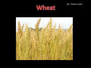
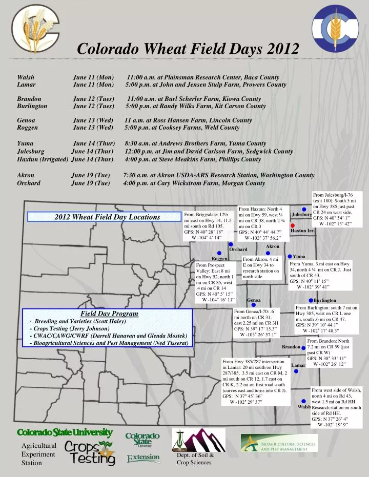
Colorado Wheat Field Days 2012. Walsh June 11 (Mon) 11:00 a.m. at Plainsman Research Center, Baca County Lamar June 11 (Mon) 5 :00 p.m. at John and Jensen Stulp Farm, Prowers County Brandon June 12 (Tues) 11:00 a.m. at Burl Scherler Farm, Kiowa County

E N D
Colorado Wheat Field Days 2012 Walsh June 11 (Mon) 11:00 a.m. at Plainsman Research Center, Baca County Lamar June 11 (Mon) 5:00 p.m. at John and Jensen Stulp Farm, Prowers County Brandon June 12 (Tues) 11:00 a.m. at Burl Scherler Farm, Kiowa County Burlington June 12 (Tues) 5:00 p.m. at Randy Wilks Farm, Kit Carson County Genoa June 13 (Wed) 11 a.m. at Ross Hansen Farm, Lincoln County Roggen June 13 (Wed) 5:00 p.m. at Cooksey Farms, Weld County Yuma June 14 (Thur) 8:30 a.m. at Andrews Brothers Farm, Yuma County Julesburg June 14 (Thur) 12:00 p.m. at Jim and David Carlson Farm, Sedgwick County Haxtun (Irrigated) June 14 (Thur) 4:00 p.m. at Steve Meakins Farm, Phillips County Akron June 19 (Tue) 7:30 a.m. at Akron USDA-ARS Research Station, Washington County Orchard June 19 (Tue) 4:00 p.m. at Cary Wickstrom Farm, Morgan County From Julesburg/I-76 (exit 180): South 5 mi on Hwy 385 just past CR 24 on west side. GPS: N 40° 54’ 1” W -102° 13’ 42” From Haxtun: North 4 mi on Hwy 59, west ¼ mi on CR 38, north 2 ¾ mi on CR 3 GPS: N 40° 44’ 44.7” W -102° 37’ 56.2” From Briggsdale: 12½ mi east on Hwy 14, 11.5 mi south on Rd 105. GPS: N 40° 28’ 18” W -104° 4’ 14” Julesburg 2012 Wheat Field Day Locations Haxtun Irr. Akron Orchard Yuma Roggen From Akron, 4 mi E on Hwy 34 to research station on north side. From Yuma, 3 mi east on Hwy 34, north 4 ¾ mi on CR J. Just south of CR 43. GPS: N 40° 11’ 15” W -102° 39’ 41” From Prospect Valley: East 8 mi on Hwy 52, north 1 mi on CR 85, west .4 mi on CR 14 GPS: N 40° 5’ 15” W -104° 16’ 11” Genoa Burlington From Burlington: south 7 mi on Hwy 385, west on CR L one mi, south .6 mi on CR 47. GPS: N 39° 10’ 44.1” W -102° 17’ 48.3” From Genoa/I-70: .6 mi north on CR 31, east 2.25 mi on CR 3H GPS: N 39° 17’ 15.3” W -103° 26’ 57.1” Field Day Program - Breeding and Varieties (Scott Haley) - Crops Testing (Jerry Johnson) - CWAC/CAWG/CWRF (Darrell Hanavan and Glenda Mostek) - Bioagricultural Sciences and Pest Management (Ned Tisserat) From Brandon: North 7.2 mi on CR 59 (just past CR W) GPS: N 38° 33’ 11” W -102° 26’ 12” Brandon From Hwy 385/287 intersection in Lamar: 20 mi south on Hwy 287/385, 3.5 mi east on CR M, 2 mi south on CR 12, 1.7 east on CR K, 2.2 mi on first road south (curves east and turns into CR J). GPS: N 37° 45’ 36” W -102° 29’ 37” Lamar From west side of Walsh, north 4 mi on Rd 43, west 1.5 mi on Rd HH. Research station on south side of Rd HH. GPS: N 37° 26’ 4” W -102° 19’ 9” Walsh Agricultural Experiment Station Dept. of Soil & Crop Sciences