Download
1 / 21
220 likes | 263 Views
Explore the geographical landscape of China, from the diverse ethnic groups to regional differences impacting culture and industry. Discover the physical features shaping China's identity, such as mountains, rivers, and cultural heartlands.

E N D
Geography of China By Prof. Ling-Ling Shih 1/17/2017
We will cover: • China’s geography EAS 201
Visual resouces • Mr. Brush's China Geography Video http://www.youtube.com/watch?v=KaZ9FP4mfu4&list=PLC1E77502F8274DED&index=1&feature=plpp EAS 201
China: • In Chinese, we call China, “Zhong Guo.” • (“Middle Kingdom”) • Where did the name “China” come from? • --”China” was used first in Qin dynasty—the first dynasty that unified China in 221 B.C.E. • The ancient Greeks knew of China as Seres, • the land of silk. • Slavics called China “Cathay” which comes from Khitai • an ethnic group once occupied in northern China. • “Han” EAS 201
Whose China? • The Han People • Share some common physical traits, but their look and height can vary from region to region. • What unified them all? • The same set of cultural traditions (Confucian norms). • 91% of Chinese are Han today. • Non-Han Minorities: • China is also inhabited by diverse non-Han minorities • including Mongolians, Tibetans, Uygurs, Manchurians, and so on. EAS 201
56 Ethnic groups in China • http://www.youtube.com/watch?v=bwuOaII-JqE&feature=related • (http://www.youtube.com/watch?v=kUrLAFXAB3k&feature=related) EAS 201
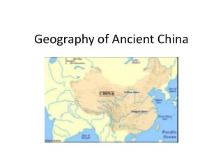
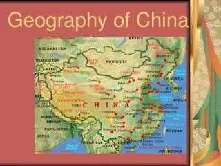
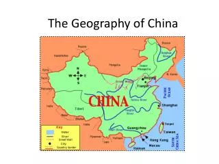
How big is China? How many people? • China is slightly larger than America. • Population • 4 times people of the U.S.—1.3 billion people. • China is described by Chinese themselves as: • “Di Da Wu Bo”—Vast territory and rich in resources. • “Di Shao Ren Zhong:--Scare land with many people • China proper: scarce land with many people • China proper + Frontier: vast territory and rich resources EAS 201
Regional Differences in geography • As the U.S. and Europe, China varies regionally. • East-West & North-South • the distinction bet/n China Proper and Frontier. EAS 201
Frontier Differences China proper
Frontier—Islam or Lama Buddhism Difference between China Proper and Frontier China Proper-- Confucianism
Frontier --Little Industry (normadic life style and farming in oases Difference China Proper --Industrial bases
Southern China Staple/Cuisines Northern China
China proper • China proper: (Gamer, map 2.3) • 90% of country’s population. • Mostly Han people with Confucian values. • A suitable area for agriculture. • Industrial bases EAS 201
Frontier: (Gamer, Map 2.3) • West of a line: “Western China” • Inner Mongolia, Heilongjiang, Jilin, Liao Ning, Ningxia, Gansu, Xinjiang, Western Sichuan, Tibet, Qinghai. • Fewer people. • Non-Han people. • Islam or Lama Buddhism. • Little industry • Mountains and deserts--Low rainfall • Nomadic life style and farming in oases EAS 201
Regional Differences within China Proper • A dividing line: the Yangtze River (Map 2.4) separate the northern & southern portion. EAS 201
Northern China vs. Southern China • Northern China: • The Yellow River waters Northern China. • The cultural heart of China • Rainfall adequate for agriculture • Heavy industry (coal, oil) • Mandarin dialect • Staples: Wheat • Cuisine: noodles, steamed buns, plainer, use onions, • Southern China: • The Yangtze River and West River--lifelines • Lush paddy agriculture • Tea on the hillsides • Light industry (textiles) • Fewer fuel resources • Southern dialects (e.g., Cantonese) • Staple: Rice • Cuisine: e.g., Hunan, Sichuan styles—spicy, Cantonese EAS 201
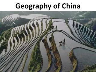
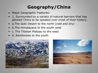
The Natural Landscape • China’s regional differences are shaped by her physical geography. • It is a land of extremes: Mt. Everest at 29,029 feet—the Turpan Depression at 505 feet below see levels. • Over two-thirds of China is mountainous, hilly, or high plateaus. But they are linked together by the river basins (Yangtze River and Yellow River) • Floods and droughts plague this land. EAS 201
Three tiers (map 2.4, Gamer--p.18) • Mountains (6,000-29,029 feet) • Tibet, Qinghai, Xinjiang, Sichuan, Gansu, Guizhou, Himalaya range • The origins of the major rivers • The hilly area (600 and 6000 feet) • Mongolian Plateau, Sichuan Basin, Yunnan Plateau. • More rainfall. • Floodplains and low lands (lower than 600 feet) • The smallest and most populous. • The Yangtze River and the paths of the Liao & Song River. • The agricultural and industrial heart of China • The delta of the West River—Principal basis for China’s rich agriculture. EAS 201