Download
1 / 37
370 likes | 457 Views
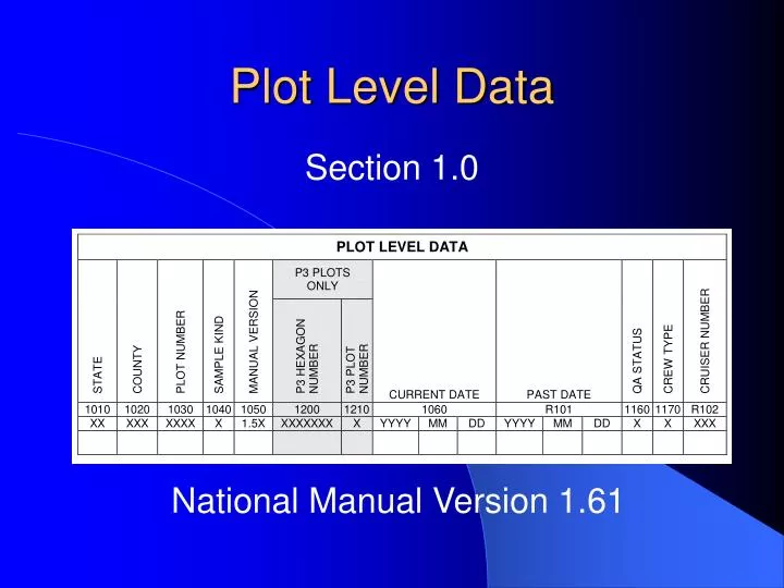
Plot Level Data. Section 1.0. National Manual Version 1.61. Plot Level Data. Section 1.0. National Manual Version 1.61. Plot Level Data. Section 1.0. National Manual Version 1.61. State. Record the appropriate state code. Louisiana 22. County. Record the appropriate county code.

E N D
Plot Level Data Section 1.0 National Manual Version 1.61
Plot Level Data Section 1.0 National Manual Version 1.61
Plot Level Data Section 1.0 National Manual Version 1.61
State Record the appropriate state code. Louisiana 22
County Record the appropriate county code.
Plot Number • Plot numbers are four digits: • 0001-0999 Standard field plots • 4001-4999 Intensification plots • 9000-9999 Temporary and supplemental plots
P3 Hexagon Number P3 plots only
P3 Plot Number P3 plots only
Sample Kind 1 Initial plot establishment (new plots) 3 Replacement plot (lost plot) 9 Prism plot remeasurement/Fixed plot establishment LA does not use: 2 Subplot design remeasurement
Manual Version Version 1.61 Updated June 3, 2002
Current and Past DateChanged Format: Year month day Example: 20020610
New ItemQA Status 1 Standard production plot 2 Cold check 3 Reference plot (off grid– not a true plot) 4 Training/practice plot (off grid– not a true plot) 5 Botched plot file (P3 PDR program only) 6 Blind check 7 Hot check of production plot • Record code 1 on most regular production plots • Record code 7 if field crew works with QA to install a regular production plot
2 QA crew (at least one QA person on plot) New ItemCrew Type 1 Standard field crew
Cruiser Number Record the unique number assigned to identify individual cruisers.
Number of Accessible Forest Land Conditions Record the number of forested conditions on the plot.
Number of Tree EntriesChanged • Only includes trees and saplings (on both subplots and prism points) • Seedlings are tallied in a separate section • Include an entry for no tree and sapling tally • on a subplot and prism point
Number of Prism Points Remeasured or Subplot Centers Reverted SK = 9 Plots ONLY: • Enter the number of Prism Points on remeasured forest plots • Enter number of subplot centers that are reverted when plot center has reverted
Trails or RoadsNew Item Code the nearest trail or road within one mile of plot center: 0 None within one mile 1 Paved road or highway 2 Improved gravel road 3 Improved dirt road 4 Unimproved dirt road 5 Human access trail
Road AccessNew Item Record the first road access restriction encountered while traveling to the starting point: 0 None 1 Road blocked by locked gate or cable 2 Road blocked by human-made obstruction 3 Road blocked by natural occurrences 4 Posted no motorized vehicle signs 9 Other (specify in plot notes)
Public Use RestrictionsNew Item Record restrictions posted for the parcel(s) of land that the plot area occupies: 0 None 1 Keep out/ no trespassing 2 No hunting or fishing 3 No dumping 9 Other (specify in plot notes) Not necessarily the same parcel where SP is located.
Recreation Use 1,2,3New Item Record up to three signs of the following recreation use on the forested portion of any of the four subplots: 0 No evidence of recreation use 1 Motor vehicle (4-wheel drive, ATV, motorcycle) 2 Horse riding, dog team trails, ski trails 3 Camping 4 Hiking 5 Hunting/ shooting 6 Fishing 7 Boating– launch site or dock 9 Other (specify in plot notes)
Human Debris Record the presence or absence of human debris on the forested portion of any of the four subplots. Record the lowest numbered item if multiple forms of debris occur. • 0 None • Noncombustible synthetic (metal, glass, etc.) • Combustible synthetic (plastic, Styrofoam, tires, etc.) • Combustible organic material (man-caused: yard waste,compost, slash piles, etc.)
Water on PlotNew Item Water sources on the forested portion of the four subplots that are not identified as a separate condition on the plot: 0 None 1 Permanent streams/ponds 2 Permanent swamp, bog, marsh 3 Ditch/canal 4 Temporary streams 5 Flood zones 9 Other temporary water (specify in plot notes)
Horizontal Distance to Improved RoadChanged Codes are now one-digit categories: 1 100 ft or less 2 101 to 300 ft 3 301 to 500 ft 4 501 to 1000 ft 5 1001 to 0.5 mile 6 >0.5 to 1 mile 7 >1 mile to 3 miles 8 >3 miles to 5 miles 9 Greater than 5 miles
Horizontal Distance to Urban or Built-Up Land Changed Use the new one-digit distance codes used for distance to improved road.
Horizontal Distance to Agricultural LandChanged Use the new one-digit distance codes used for distance to improved road.
Size of Contiguous Forest Land Record the code that indicates the size of the contiguous forest around plot center using only the photo on which the plot is located.
GPS CoordinatesChanged • Attempt to average 180 readings • Attempt to keep error reading no more than +/- 70 feet • Elevation is recorded in feet above mean sea level • Option of reporting offset coordinates within 200 feet of plot center
GPS UnitNew Item 0 GPS coordinates not collected 1 Rockwell PLGR 2 Other brand capable of field averaging 3 Trimble GeoExplorer or Pathfinder Pro 4 Recreational GPS (Garmin, Magellan, etc.) Only record code 0 if coordinates cannot be collected at all within 200 feet of PC (unit is damaged, heavy canopy cover, mountain coves, no GPS unit available, etc.) Always record readings collected within 200 feet of PC, even if less than 180 readings are obtained or even if error reading is more than +/- 70 feet.
GPS Serial NumberNew Item Record the six-digit serial number of the GPS unit
Latitude/Longitude Record the latitude and longitude to the nearest 100th second Example: 36° 47’ 05.25” 086° 34’ 29.51”
GPS ElevationChanged Now measured in feet above mean sea level
GPS ErrorNew Item • Record error reading of the averaged coordinates • Make every effort to collect readings with less than or equal to 70 feet of error • Record coordinates if cannot obtain an error reading less than +/- 70 feet
Number of ReadingsNew Item • Record number readings averaged • Make every effort to collect 180 readings • Record coordinates if cannot obtain 180 error readings
Azimuth and Distance to PCNew Item • Leave blank if using a PLGR, even if coordinates are range-calculated. • We are not using this in the South as long as we are using PLGRs.
Plot Level NotesNew Item Record notes pertaining to the entire plot or to a plot level item