Enhancing Municipal Operations Through Parcel-Based GIS Integration
Explore the critical role of parcel identification and property-based recordkeeping in municipal operations. This system ensures every department, including tax assessment, planning, and emergency response, effectively manages parcel-related information. By integrating diverse databases with GIS parcel data, municipalities can enhance their operational capabilities. The potential applications, from sales analysis to zoning consistency, underscore the importance of accurate and accessible parcel data. Municipal managers David Dos Reis and Maria Giarrusso provide insight into optimizing GIS for urban planning.

Enhancing Municipal Operations Through Parcel-Based GIS Integration
E N D
Presentation Transcript
Parcels The Foundation of Municipal GIS
Parcel Identification and Property-Based Recordkeeping are Necessary for All Aspects of Municipal Operations • Every Department Manages Information Related to a Parcel (or Indirectly by Address) • Tax Assessor • Planning • Building Inspections • Public Works • Emergency Response • …
Being Able to Associate Other Databases With Parcels Expands Its Capabilities and Increases Its Effectiveness as a Municipal Tool Capabilities Related Data
Basic GIS Parcels • ID • Street Names • Lot Dimensions • CAMA Data • Assessments • Land Use Codes • Personal Property Inventory • Title Cards • Ownership • Mailing Addresses • Sales • Chain of Title • Document Management • Images • Non-Tabular Data ?????? + + + + Possibilities are Endless!!! Revaluation and Land Use - Analysis & Mapping Abutter's Lists Mailing Labels Sales Analysis View Deeds Ex: Historical Property Cards Tax Maps
Why/How It Works • GIS Parcels Identified with Parcel ID (Usually Plat-Lot) • Other Databases Contain a GISID and PropertyID Field • GISID Joins to Parcel ID in Parcel Feature Class • PropertyID = Plat-Lot-Condo (Unique) • Condominium Records – Stacked Polygons • Nightly Process Creates a “Super-Parcels” Feature Class (ArcSDE) • Some Examples….
Tax Assessor • Property Inventory • Assessed Values • Ownership • Digital Tax Maps • GIS Viewer • PDFs On-Line • Abutters Map • Mailing Labels • Revaluation Support • Sales • Reval Trends • Maintains GIS Parcels
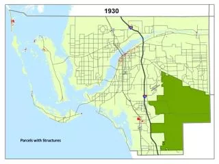
Planning Department • Land Use • Zoning Consistency • Flood Zone Properties • Build-Out Analysis • Comp Plan Maps Purpose: To determine the number of units that could be subject to future Western Cranston Water System (PWB) Connection Fees
Public Works Sewer Billing vs. GIS Infrastructure Data
Providence GIS • David DosReis, GISP • GIS Manager
Questions/Comments? Maria Giarrusso GIS Manager City of Cranston mgiarrusso@cranstonri.org 401-780-3178 David DosReis GIS Manager City of Providence ddosreis@providenceri.com 401-680-8535