Download
1 / 26
260 likes | 282 Views
Learn how to edit and maintain parcels using ArcMap. This workshop introduces the Parcel Fabric and covers the Parcel Fabric Data Model, editing techniques, and tips for data entry.

E N D
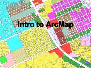
Editing & Maintaining Parcels with ArcMap Amy Andis Jason Camerano
What to expect from this Tech Workshop • An introduction to the Parcel Fabric • A detailed explanation of the Parcel Fabric Data Model • General editing techniques using Parcel Editing tools • Tips and tricks for data entry Editing and Maintaining Parcels
Why use the Parcel Fabric? Optimized Data Model for Maintaining Parcels Preserves original recorded information Ensures topology between parcels Supports Overlapping Parcels Maintain Historic Parcels Efficient workflows Adjust to Control Points Create a More Accurate parcel layer Editing and Maintaining Parcels
Parcel Fabric Data Model Editing and Maintaining Parcels
Parcel Fabric Data Model Optimized Data Model for Parcels Editing and Maintaining Parcels
What is a Parcel Fabric? Parcel Fabric Data Model 1 Plans Parcels 1 1-M Lines Points 1 1-M 2-1 1 0-1 0-1 Line Points Control 0-M Editing and Maintaining Parcels
Plans Store and Manage recorded information about parcels One or many parcels are contained within a plan Editing and Maintaining Parcels
Parcels Lines have related points Parcel Polygon has related lines Editing and Maintaining Parcels
Lines and Points Lines store record dimensions 91 90 To Point From Point # of lines= 16 # of points = 9 # of parcels = 4 88 89 Points are stored on the ends of lines or curves Editing and Maintaining Parcels
Line Points Preserve original record dimensions 10 15 11 14 Ensure topology between parcels Editing and Maintaining Parcels
Control Points • Related to parcel points • Can be added by importing or manually added to the Parcel Fabric • Control points are in the fabric in order to do Least Squares Adjustment (LSA). Editing and Maintaining Parcels
Data Model Supports All Subdivisions, Lots, Tax Parcels, etc. are “Parcels” in the Parcel Fabric Editing and Maintaining Parcels
Data Model Supports True parametric curves and radial lines Natural boundaries Donut/island and multipart parcels Historic parcels Stacked parcels (Condos) Editing and Maintaining Parcels
Demo: Data Model Amy Andis Editing and Maintaining Parcels
Parcel Editing Editing and Maintaining Parcels
Parcel Editing Tools Construct from Parent Parcel Parcel traverse Parcel division Parcel merge Parcel remainder Built-in COGO tools Bearing, distance, tangent curve, intersection, parallel, perpendicular, etc. Parcel joining Editing and Maintaining Parcels
Utilizing the Local Government Information Model Part of the Land Records Solution Predefined Layers and Symbology Predefined Domains Efficient Workflows Editing and Maintaining Parcels
Parcel Editing Workflows Utilizing the Local Government Information Model Editing and Maintaining Parcels
Demo: Parcel Editing Amy Andis Editing and Maintaining Parcels
Recap: Why use the Parcel Fabric? Optimized Data Model for Maintaining Parcels Preserves original recorded dimensions Ensures topology between parcels Supports Overlapping Parcels Option to maintain history Efficient workflows Adjust to Control Points Create a More Accurate Parcel Layer Editing and Maintaining Parcels
Additional offerings - Tuesday • An Overview of Community Parcels (Demo) • Tue 7/15/2014, 11:30 AM - 12:00 PM, Demo Theater - ArcGIS Solutions Exhibit Hall B • Tue 7/15/2014, 5:30PM – 6:15 PM, Demo Theater - ArcGIS Solutions Exhibit Hall B • Editing and Maintaining Parcels with ArcMap (TW) • Tue 7/21/2015, 01:30 PM - 02:45 PM, Room 02 • ArcGIS for Land Records: An Overview (TW) • Tue 7/15/2014, 01:30 PM - 02:45 PM, Room 31 B • Approaches to Building a National Parcel Data Base (Demo) • Tue 7/15/2014, 04:30 PM - 05:00 PM, Demo Theater - State and Local Government
Additional offerings - Wednesday • Migrating Data into the Parcel Fabric Solution (TW) • Wed 7/22/2015, 08:30 AM - 09:45 AM, Room 03 • An Overview of the Urban Land Bank and Tax Reverted Properties Maps and Apps • Wed 7/16/2014, 11:30 AM - 12:15 PM, Demo Theater - Exhibit Hall B • Modern Approach to Land Records (Demo) • Wed 7/16/2014, 11:30 AM - 12:15 PM, Demo Theater - Exhibit Hall D • Advanced Parcel Editing in ArcMap (TW) • Wed 7/22/2015, 03:15 PM - 04:30 PM, Room 02 • ArcGIS for Land Records: An Overview (TW) • Wed 7/22/2015, 03:15 PM - 04:30 PM, Room 33 A • Approaches to Building a National Parcel Data Base (Demo) • Wed 7/16/2014, 05:30 PM - 06:00 PM, Demo Theater - State and Local Government
Additional offerings - Thursday • ArcGIS for Land Records: Unlock the Potential of Parcel Data (Demo) • Thu 7/23/2015, 9:30 AM - 10:15 AM, Demo Theartre - Exhibit Hall B • An Overview of the Land Records Public Access Applications (Demo) • Thu 7/23/2015, 9:30 AM - 10:15 AM, Demo Theartre - Exhibit Hall B • Editing and Maintaining Parcels with ArcMap (TW) • Thu 7/23/2015, 10:15 AM - 11:30 AM, Room 02 • Modern Approach to Land Records (Demo) • Thu 7/23/2015, 10.30 AM - 11:15 AM, Demo Theater - Exhibit Hall D • Advanced Parcel Editing in ArcMap (TW) • Thu 7/23/2015, 03:15 PM - 04:30 PM, Room 02 • Land Records Meetup (SIG) • Thu 7/23/2015, 12:00 PM - 01:00 PM, Room 31 B
Community – Land Records Meetup Join the Land Records Meet-up today Editing and Maintaining Parcels
Thank you… • Please fill out the session survey in your mobile app • Select Editing & Maintaining Parcels with ArcMap in the Mobile App • Use the Search Feature to quickly find this title • Click “Technical Workshop Survey” • Answer a few short questions and enter any comments