NAVTEQ Parcels
240 likes | 464 Views
NAVTEQ Parcels. August 2007. What is a Parcel?. Parcel: A land record that defines the boundary of a piece of land. The basic administrative unit of local government.

NAVTEQ Parcels
E N D
Presentation Transcript
NAVTEQ Parcels August 2007
What is a Parcel? • Parcel: A land record that defines the boundary of a piece of land. The basic administrative unit of local government. • Parcels are most commonly produced for tax assessments. These tax maps are used for locating and describing properties that are linked to owners, tax bills, and other assessment information. • Parcels typically represent a generalized portrayal of parcel locations and dimensions rather than a highly accurate representation of legal ownership. • Parcel maps have generally had no federal or state oversight with their development so content, procedures, methods, and standards widely vary at the local level.
NAVTEQ Parcels: Quality and Value • Coverage: Our second quarter 2007 database has approximately 63 million parcels– representing the most comprehensive packaged database of parcel information available today. • Standardization: Parcels are maintained by thousands of tax mapping authorities in the United States, each with disparate format, projection, and data models. NAVTEQ has built a standard format, structure, and projection and secured standard redistribution rights. • Secured Usage: Parcel sources have highly varied usage/distribution policies, by developing relationships with local governments, NAVTEQ has taken the time to understand and secure usage rights for our markets. • Reliability: All parcel data is qualified for data completeness and integrity. • Product Growth: NAVTEQ has a team dedicated to building our Parcel Boundaries. We add parcel coverage each month and we are surveying the market for the addition of value-adding attributes.
NAVTEQ Parcels – Quality Assurance Steps • Re-projection: All parcel files are reprojected for consistency. • NAVTEQ centerline alignment: All parcels are overlaid with NAVTEQ street centerlines for positional accuracy – misaligned parcels are rejected. • NAVTEQ APN and Address fields: APN and Address fields examined for consistency and completeness. Frequently, sources provide sparse or poor quality address information – in these cases we will not incorporate these Parcels into our data. Currently approximately 80% of NAVTEQ Parcel Boundaries have address information. NAVTEQ is taking measures to improve this addressing and expand the inclusion by employing innovative techniques. • Ortho-Photo alignment: Each parcel source undergoes a sampling procedure to check for alignment to ortho-photography – misaligned parcels are not included in our product. • Spatial Accuracy Rating: The rating of location accuracy assigned to the parcel data which is calculated by taking measurements off the ortho-photograph and averaging the results
Parcel Data Structure • The structure is consistent for all NAVTEQ Parcel Data. • The contents of the address field have not been standardized across counties. Address quality can vary based on wide-ranging standards across our local government sources.
NAVTEQ Parcels - Release Notes (Metadata) NAVTEQ Parcels are shipped with Metadata: • FIPS: The county FIPS code. • Sub-County ID: The FIPS code for the collection unit if it is smaller than a county. • Parcel Count: The total amount of parcel records for that collection unit. • Spatial Accuracy Rating: The rating of location accuracy assigned to the parcel data which is calculated by taking measurements off the ortho-photograph and averaging the results.
NAVTEQ Parcel Boundaries: Uses and Benefits Internet Mapping • Adds rich visual context to a map • Real-estate searching and reporting • Brings more meaning to locations Emergency Preparedness • Estimate disaster losses • Search and rescue support • Destroyed property identification Enterprise Solutions • Retail site selection • Infrastructure planning • Insurance risk exposure determination • Regional planning Location Intelligent Analysis • Urban growth prediction • Site large development projects • Assist property value verification • Population analysis
Parcel Boundaries Bring New Meaning to a Map - San Diego, CA
NAVTEQ Parcel Boundaries fit NAVTEQ Streets - San Diego Imagery Courtesy of DigitalGlobe
Expanding the Attributes of NAVTEQ Parcel Boundaries • Each Parcel record includes a key identifier known as the APN – this is the official PIN number of a property. • This field can feasibly be linked with any other data that is “joinable” to this key field. • Major title companies and MLS-based databases offer possibilities to add information such as ownership, valuation, zoning and home age to Parcel Boundaries. • Examples include Fidelity National, First American, and DataQuick. • Augmentation with secondary data sources cab greatly broaden the use cases and application possibilities of NAVTEQ Parcel Boundaries. • Data disparities across counties could complicate a data join with NAVTEQ Parcel Boundaries. • Currently NAVTEQ offers no warranty on joining third-party data – it is possible but some assembly is required.
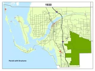
Use Parcels to Proactively Identify Urban Growth Parcel Boundaries can serve as an X-ray onto the landscape for development prediction. Here, parcels reveal that a municipality has divided an undeveloped area for residential expansion. Imagery Courtesy of DigitalGlobe
Parcel Boundaries Indicate Land Use Note: Older image does not reflect apparent development Image: 2002 Parcels: 2006 Imagery Courtesy of DigitalGlobe
Parcel Boundaries Indicate Land Use Image: 2004 Parcels: 2006 Note: Newer image now reflects newer development Imagery Courtesy of DigitalGlobe
Parcel Boundaries Enable More Accurate Risk Assessment Example: Properties at Risk of Storm Surge. Boundaries reveal partial or complete membership to risk categories.
Parcel Boundaries Provide Rich Context to a Map Parcel Boundaries in Google Earth. Teton, WY Do not distribute without permission from Google
Parcel Data for Geocoding – Uses and Benefits • Enable superior position accuracy and improved match rates • Support your geocoding with household-level accuracy • Increases confidence in ‘destination selection’ and subsequent use of geocoding results (such as tax and risk determination) • Reduce costs by decreasing false positives and the need for manual matches
Enhance Address Locating with Parcel Data 1) Black dots show geocoded locations using street addresses 2) Green squares show geocoded locations using Parcels 3) Red line shows distance between the two
Improve confidence when using your geocoding results Costal surge risk determined using a parcel-based geocoded location. Applications like this demanding great positional accuracy are a great fit for NAVTEQ Parcel Data for Geocoding. NAVTEQ Parcel Boundaries enhance the display of these results.
Sourced and Assimilated Enhanced and Integrated Phased Development Phase 1 Phase 2 Phase 3 Phase 4 Initial Release 50-60 Million Parcels Build Out Dataset Estimated 65-80 Million Parcels Add Attributes / Standardize Address Begin Updates Obtain remaining Parcels Reposition to NAVTEQ Map