Download
1 / 12
120 likes | 292 Views
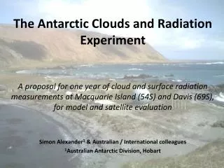
The Antarctic Clouds and Radiation Experiment A proposal for one year of cloud and surface radiation measurements at Macquarie Island (54S) and Davis (69S), for model and satellite evaluation. Simon Alexander 1 & Australian / International colleagues 1 Australian Antarctic Division, Hobart.

E N D
The Antarctic Clouds and Radiation ExperimentA proposal for one year of cloud and surface radiation measurements at Macquarie Island (54S) and Davis (69S), for model and satellite evaluation Simon Alexander1 & Australian / International colleagues 1Australian Antarctic Division, Hobart
Current Project Team(alphabetical listing…) Simon Alexander (AAD) Charmaine Franklin (CSIRO/CAWCR) Murray Hamilton (University of Adelaide) Christian Jakob (Monash University) Philippe Keckhut (LATMOS, France) Melita Keywood (CSIRO/CAWCR) Andrew Klekociuk (AAD) Tom Lachlan-Cope (BAS) Roger Marchand (University of Washington, USA) Adrian McDonald (Canterbury) Alain Protat (CAWCR) Phil Reid (Bureau of Meteorology) Steve Siems (Monash University)
Hobart (43S) Davis (69S) Macquarie Island (54S)
Project Goals • (1) Quantify key cloud and radiation properties between sub-diurnal and seasonal time-scales using a suite of ground-based instruments deployed and operated on a campaign basis at Davis and Macquarie Island (collectively referred to as the ‘ACRE dataset’). • (2) Evaluate cloud and radiation products from Australian and international climate models against the specific parameters collected or derived from the ACRE dataset. • (3) Evaluate high-resolution numerical forecasting models at Davis and Macquarie Island using the ACRE dataset and ancillary data streams. • (4) Validate satellite cloud observations and products over the Southern Ocean and Antarctica. • (5) Investigate the structure and evolution of clouds on sub-climate model grid scales in the Davis region by performing high-resolution nested model case studies.
Routine Observations at Macquarie Island and Davis • 12-hourly radiosonde launches (daily at Davis during winter) • Ozonesonde launches (~weekly) • AWS: 1-min resolution T, P, RH, rainfall amount, wind speed & direction • Observers make 3-hourly visual observations of cloud • Davis has a wind-profiling radar which provides u, v, w from ~2 – 13km altitude.
Instruments to Macquarie Island • Intensive Observation Period (IOP) proposed for March 2016 – March 2017. (Based on logistics schedule) • Deploying: • CAWCR millimeter cloud radar (LWC, IWC, reflectivity, cloud fraction, thickness etc.) • CAWCR cloud and aerosol backscatter lidar (IWC, backscatter etc.) • CSIRO cloud condensation nuclei (CCN) counter (aerosols which form cloud droplets) • ARM radiometers hopefully (next slide) • We can consider deploying additional, low-maintenance instruments if there is interest from the community
Request for ARM radiometers for Macquarie Island • Currently we (Roj, Alain, Simon…) are drafting a request for ARM to provide instruments for Macquarie Island (March 2016 – March 2017) • Microwave radiometer (column-integrated liquid water & water vapour) • Surface broadband radiometers (sky and ground, shortwave and longwave) • Sun photometer or Multifilter Rotating Shadowband Radiometer (MFRSR): optical depth
Instruments to Davis • Intensive Observation Period (IOP) proposed for either November 2017 – November 2018; or November 2018 – November 2019 (Based on logistic schedule) • Still need to finalise dates, depending on instrument availability • Note the proposed Year of Polar Prediction is scheduled for mid-2017 to mid-2019. • Deploying / operating (at this stage): • CAWCR millimeter cloud radar (LWC, IWC, reflectivity, cloud fraction, thickness etc.) • AAD Rayleigh lidars (one already on-site) • University of Adelaide water vapour lidar • AAD VHF wind-profiling radar operational at Davis • AAD sky & ground radiometers (requesting funding to purchase) • We can consider deploying additional, low-maintenance instruments if there is interest from the community
Davis Rayleigh Lidar • We have a high-powered lidar at Davis which is capable of resolving clouds (τ < 3) with fine temporal and spatial resolution • We propose to use this system for 2 or 3 years (including during the Davis IOP) to construct a cirrus cloud climatology • We will ask for funding to purchase broadband surface radiation instruments to deploy to Davis on a multi-year timescale. Data from these instruments would become available to the community after quality control.
Data analysis (1/2) • Observational quantification of key cloud and radiation properties • Cloud composites: optical depth, thickness, altitude, temperature, phase etc. • Surface radiation composites and relation to cloud cover, cloud type • Evaluation of climate models (e.g. ACCESS Australian model) • Model outputs many of the cloud & radiation parameters which we will collect. Evaluation of e.g. model’s ability to simulate seasonal variability of the cloud and radiation fields • The results from the evaluation of ACCESS will inform sensitivity tests that will be conducted to guide model development work • Simulations will test changes to the statistical cloud and cloud microphysics schemes including for example the ice nucleation assumptions, ice particle size distributions, fall speed and autoconversion parameterisations. • Together with the observations, this experiment will identify key contributors to the errors in the simulation of Antarctic and Southern Ocean clouds in ACCESS. This knowledge will then enable targeted development work to improve the representation of these clouds and their radiative effects in the ACCESS climate model.
Data analysis (2/2) • Evaluation of high-resolution numerical forecasting models • The ground-based observations will be used to evaluate the representation of low-level clouds and the diurnal variability of cloud properties, while the satellite observations will be most appropriate to evaluate the mid-level and high level cloud properties as produced by the different models. • Validation of satellite cloud observations at Southern high latitudes • When the full suite of instruments are deployed to Davis and Macquarie Island, we will have all the necessary parameters to compare the CALIOP and CloudSat official and experimental retrievals of cloud phase, microphysics, overlap, fraction, thickness and heights • The three years of cloud data to be collected with the Davis Rayleigh lidar will provide a more comprehensive analysis for ground-based - satellite evaluation of Antarctic cirrus. • The structure and evolution of clouds on climate model sub-grid scales • High-resolution ACCESS-CP (CitiesPolar) forecast case studies will be used to understand cloud and thermodynamics on the regional scale at Davis, combined with both lidars, the cloud radar and the wind-profiling radar.
Current Status • To conduct any science on Macquarie Island or in the Australian Antarctic Territory, we have to apply to AAD whenever there is a call for science applications. Applications are peer-reviewed. • Unfortunately we have no definite date when this call for applications will next open (it was supposed open some time ago…). Possibly in the next couple of months… • March 2016 – March 2017: Macquarie Island year-long IOP • Nov 2015 – Nov 2018 (or Nov 2016 – Nov 2019): Rayleigh lidar operational at Davis • Nov 2017 – Nov 2018 (or Nov 2018 – Nov 2019): Davis year-long IOP