Download
1 / 30
300 likes | 456 Views
Map and Globe Skills Day 3. The Globe: The World and its continents. Do Now (5 Mins ). Fill in your week sheet Objective: Use maps to identify the world’s continents and oceans EQ: How do maps show the way the world is organized? Homework: Finish world map

E N D
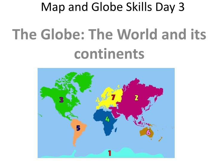
Map and Globe Skills Day 3 The Globe: The World and its continents
Do Now (5 Mins) • Fill in your week sheet Objective: Use maps to identify the world’s continents and oceans EQ: How do maps show the way the world is organized? Homework: Finish world map Do Now: Have you ever visited any other continents or countries? Can you list the world’s continents and oceans? Remember to fill in one thing you learned in class yesterday!
Have you ever visited any other continents or countries? Can you list the world’s continents and oceans? • Let’s take a look at the world’s continents and oceans!! • http://www.youtube.com/watch?v=oCW-dJyBrog As the video plays, fill in the World’s continents and oceans on your handout!
There are SEVEN continents on the map: North America, South America, Europe, Asia, Africa, Australia, and Antarctica. • There are FOUR oceans: Atlantic Ocean, Pacific Ocean, Indian Ocean, and Arctic Ocean.
The world is pretty big, how do people make sense of it all? • Geographers use globesas small scale designs of the world • The world is divided into hemispheres, or halves of the world. • Geographers use imaginary lines called the Equator and the Prime Meridianto divide the world into hemispheres (follow along with your “The Four Hemispheres Handout)
If you break the world in half at the Equator, it separates the world into the Northern and Southern hemispheres <- EQUATOR
If you break the world in half at the Prime Meridian, it separates the world into the Eastern and Western hemispheres
2 important facts!! • The Prime Meridian runs through the city of Greenwich, England • As you get closer to the equator, the temperature gets HOTTER Now answer questions 1 and 2 on the back of your handout
What does the world Look like to you? • 1. Fold your paper HOT DOG style. Label the Equator • Fold your paper HAMBURGER style. Label the Prime Meridian • Sketch the world’s continents. Label the 7 Continents and 4 oceans If you don’t finish today, finish this map for homework tonight. Be creative, this assignment will be graded!
Map and Globe Skills Day 5 Physical and Political Features and Maps
Do Now Fill in your week sheet Objective: Identify physical and political features and maps EQ: What is the difference between physical and political maps and features? Homework: Review notes Do Now: Consider the lists of important features found in Georgia. What kinds of things are in List 1? What kinds of things are in List 2? • List 1: Stone Mountain, Savannah River, Chattahoochee River • List 2: Atlanta, Gwinnett County, Norcross Remember to fill in one thing you learned in class yesterday!
Do now reviews • List 1: Stone Mountain, Savannah River, Chattahoochee River List 1 contains examples of physical features • List 2: Atlanta, Gwinnett County, Norcross List 2 contains examples of political features
Physical Feature • A physical feature is a characteristic of a place whichoccurs (happens) naturally, such as a landform, body of water, climate pattern, or resources. • Examples: mountains, rivers, oceans, lakes, valleys
Political Feature • A political feature shows human-made representations on paper or other material Examples: a country's territories, boundaries, capital(s), cities
There are many other types of mapswhich show different kinds of information Historical Maps Road Maps Climate Maps Natural Resource Maps Land Use Maps Population Density Maps Etc…
Identifying physical and political features • Instructions: 1. One side of the room is labeled political features, and the other side is labeled 2. When I read off each feature, move to the side of the room that is correct Example – If I say City, everyone move to the side labeled political feature
Physical or Political • River • International boundary • Water depth • Continent • City • Lake • Northern Hemisphere • Country • Ocean • Equator • Valley • Desert • Capital • Mountain
What kinds of information is shown on maps? • Why do you think there are so many different kinds of maps? • Flip through your atlas and make a list of the types of maps you see!
Map and Globe Skills Day 6 Latitude and Longitude
Do Now Fill in your week sheet Objective: Use longitude and latitude to determine absolute location EQ: How is latitude and longitude used to determine location? Homework: Complete handout Do Now: • What is the equator? Which way does it run? • What is the Prime Meridian? Which way does it run? Remember to fill in one thing you learned in class yesterday!
Do Now • What is the equator? Which way does it run? The Equator is a line of LATITUDE that runs from side to side, from east to west • What is the Prime Meridian? Which way does it run? The Prime Meridian is an imaginary line that runs from top to bottom or from north to south
What are lines of Latitude and Longitude? Why are they important? • Latitude and Longitude are the crisscrossing lines on maps with numbers by them. • These lines and numbers form a grid system that allows us to describe the absolute, or exact, location of any place on Earth.
Absolute vs. relative location Think about the location of your house The absolute location is your Address The relative location would be your neighborhood or street Absolute location is more EXACT than Relative location
The Coordinate system:Latitude and Longitude • The lines running east to west around the Earth are called lines of latitude. They measure degrees north and south of the equator. Maps101.com
The Coordinate system:Latitude and Longitude • The lines running north to south around the Earth are called lines of longitude. They measure degrees east and west of the Prime Meridian. Maps101.com
The coordinate system • Together, lines of latitude and longitude form a grid system called the coordinate system. • When you state the coordinates of a place on the Earth you are giving its absolute location. Maps101.com
If you were to write the coordinates of a location, write the longitude, then latitude Sometimes, you will have to guess the coordinates if they do not look exact Example: Athens (34 N, 83.5 W)
Let’s find the locations of Philadelphia Key West 3. Which cities are near 40 degrees West? 4. Which cities are near 40 degrees north?