Download
1 / 39
390 likes | 525 Views
MAP AND GLOBE SKILLS. Map and Globe Skills (WS1). Equator – imaginary line half way between the North and South Pole Hemisphere – “hemi” means ½ of something “sphere” circular object. Map and Globe Skills (WS 2). North Pole 90 degrees north latitude

E N D
Map and Globe Skills (WS1) • Equator – imaginary line half way between the North and South Pole • Hemisphere – • “hemi” means ½ of something • “sphere” circular object
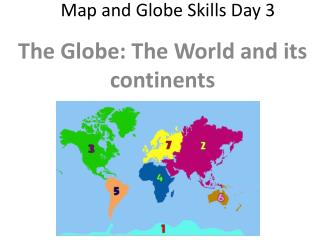
Map and Globe Skills (WS 2) • North Pole 90 degrees north latitude • South Pole 90 degrees south latitude • Continue to the next page!
Map and Globe Skills (WS 2) • Latitude – line running east and west on a globe/map that measure north and south distances • Longitude – Lines running north and south on a globe/map that measure east and west distance
Map and Globe Skills (WS 3) • Tropic of Cancer line of latitude at 23 ½ degree north latitude • Tropic of Capricorn line of latitude at 23 ½ Degree south latitude
Map and Globe Skills (WS 3) • Arctic Circle line of latitude at 66 ½ degree north latitude • Antarctic Circle line of latitude at 66 ½ degree south latitude
Map and Globe Skills (WS 4) • Global Grid: pattern of lines on a chart or map, such as those representing latitude and longitude
Map and Globe Skills (WS 5) • Mercator projection the shapes of the continents are distorted at the poles and somewhat compressed near the equator • P. 19 of your text book
Map and Globe Skills (WS 6) • Polar Projection The polar projection is an azimuthalprojection drawn to show Arctic and Antarctic areas.
Map and Globe Skills (WS 7) • Cultural maps description of what the people who live in our area like most about where and how they live etc. • Working with basic elements of a map
MAP AND GLOBE SKILLS (WS 8) • Scale bars are often included in images for presentation and publication • This activity shows the following National boundary State boundary Cities
Map and Globe Skills (WS 9) • Comparing maps with different scales • Projects are different on this activity
Map and Globe Skills (WS 10) • Elevation map The elevation of a geographic location is its height above a fixed reference point, often the mean sea level.
Map and Globe Skills (WS 11) • Cultural/physical map of Canada shows the capital, other cities, national boundaries, provincial boundaries
Map and Globe Skills (WS 12) • Shows the cultural /physical map of the Scandinavian countries and it’s neighboring countries
Map and Globe Skills (WS13) • Cultural/physical map of China
Map and Globe Skills • Cultural/physical map of Australia: shows the national capital, state or territorial capital, cities, and state boundaries
Map and Globe Skills (WS 15) • Population density map of the U.S. • Density: Population density is a measurement of population per unit area or unit volume
Map and Globe Skills • Population density of Russia and it’s former Republics