Download
1 / 16
170 likes | 301 Views
WRSM2000 (Water Resources Simulation Model) is a sophisticated mathematical model designed to simulate water movement in interconnected catchments, rivers, reservoirs, and irrigation areas. The modular design features four module types linked by routes representing water flow paths. Users can easily create and edit modules and networks within the Windows environment. Key enhancements include runoff, channel, reservoir, and irrigation modules. These allow for detailed analysis of hydrological processes, making WRSM2000 essential for effective water resources management and planning.

E N D
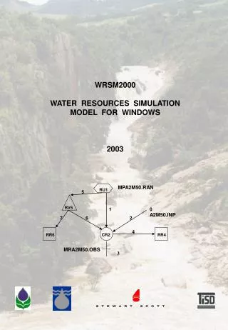
MPA2M50.RAN RU1 5 RV5 1 0 A2M50.INP 6 7 2 4 RR6 CR2 RR4 MRA2M50.OBS WRSM2000 WATER RESOURCES SIMULATION MODEL FOR WINDOWS 2003 3
Page 1 L:\common=\wrsm90\program\courses\course-powerpoint.ppt • WRSM2000 • (WATER RESOURCES SIMULATION MODEL) • WRSM2000 Overview • WRSM2000 is a mathematical model tosimulate the movement of water through an interlinked system of catchments, river reaches, reservoirs and irrigation areas. • WRSM2000 is of a modular construction, with four different types of module linked by means of routes. • The routes represent lines along which water flows, such as river reaches. • The first step towards using WRSM2000 is to set up the network of modules and routes representing the network. • The Windows version allows the user to create and edit the network and modules within the program.
Page 2 L:\common=\wrsm90\program\courses\course-powerpoint.ppt • Background • Most other rainfall-runoff models except ACRU have the Pitman model as the heart of their model. • An update is due for release in the next few months which deals with alien vegetation and CSIR afforestation. • Numerous refinements have been considered. • Some of the more major enhancements such as inclusion of a water quality model and daily modelling have been considered to be more appropriate as separate models. • WRSM2000 does have an equivalent daily Pitman model. PITMAN
Page 6 L:\common=\wrsm90\program\courses\course-powerpoint.ppt • Runoff Module • The runoff module is the heart of WRSM2000 and it retains a strong similarity to the original Pitman model. • This submodel contains the 11 calibration parameters describing the soil-moisture interface; • catchment and meteorological data is required; • pan factors are read in as data; • the growth of afforestation and impervious areas is represented by reading in values for up to ten different years; • the module also has the facility to send fixed proportions of the total runoff along various routes and • alien vegetation and CSIR afforestation have been added to the latest version. Alien Forest Alien
Page 7 L:\common=\wrsm90\program\courses\course-powerpoint.ppt • Channel Module • The main function of the channel module is to collect the inflows to it from various routes and to redistribute these flows along the outflow routes. • Inflows can be in the form of predefined flows or calculated outflows. • Outflows can also be predefined flows but are more often calculated demands from adjacent irrigation modules. • The principal outflow route represents the main river channel and surplus flow is passed along this route after all demands are satisfied. • The channel module also makes provision for bed losses and evaporative losses from a wetland area. The area of wetland can be set at a constant value or allowed to vary in accordance with the inflow via a simple power relationship. • If there is a wetland to be simulated, the module requires monthly pan values and associated pan factors. A Rainfile and MAP must also be specified so that the net evaporative loss can be computed.
Page 8 L:\common=\wrsm90\program\courses\course-powerpoint.ppt • Reservoir Module • The reservoir module can be used to represent a single reservoir or an equivalent dam made up of any number of small dams. Storage and surface area for up to ten different years can be entered. • Evaporation is calculated in a similar way to that for wetlands. • The reservoir module collects inflows and distributes outflows in a manner similar to that described for the channel module with the essential difference is the effect of storage.
Page 9 L:\common=\wrsm90\program\courses\course-powerpoint.ppt • Irrigation Module • This module calculates irrigation water • requirements as follows : • Changes of irrigation area over time can be represented by inputting values for up to ten years. • The choice of pan type and pan factor is left to the user. • MAP of the irrigation area and its rainfall pattern need not be the same as the catchment (runoff module) in which it lies geographically; • A limit (in mm) can be placed on the abstraction in any one year and effective rainfall factors can be read in for each month and • The module also allows for a seasonal cropping pattern in the form of monthly factors giving the area irrigated as a proportion of the total area. • Return flow, as a percentage of the application, can take place along a specified route.
Page 10 L:\common=\wrsm90\program\courses\course-powerpoint.ppt • Gauging Stations • Gauging Stations are associated with Routes and contain data about historically observed flows. Gauging Stations are used to compare the simulated flows with observed flows in a route. • It is important to distinguish a Gauging Station on a route from a Defined Flow in a route. Gauging Stations are used for comparison only whereas Defined Flows push or pull the flows in the model.
Page 11 L:\common=\wrsm90\program\courses\course-powerpoint.ppt • Network • The main function of the network is to specify the order in which the modules must be solved. In addition, the network is used to set the time period for simulation, routes and reservoirs can be reported in the summary file. The summary file is an easy-to-check file in which flows in the specified routes or storages in the specified reservoirs are stored on a monthly basis during a simulation run. Summary
Page 12 L:\common=\wrsm90\program\courses\course-powerpoint.ppt • Rainfall files • A Rainfile is a file that contains a monthly rainfall time series expressed as percentages of MAP for an area or a catchment. A Rainfile usually combines the data of multiple raingauges into a single time series and, in addition, the values are expressed as a percentage of the MAP for the area or catchment. Year 2000 compatible Rainfiles can now created by means of WRSM2000.
Page 13 L:\common=\wrsm90\program\courses\course-powerpoint.ppt • Operation • Operation of WRSM2000 is facilitated by a Windows style main menu that gives a number of options to the user, including running the simulation, viewing statistics, plotting graphs, changing model parameters and writing results to output devices. The model stores all information internally, so that any number of runs can be undertaken without terminating the program. This facility, in conjunction with the ability to look at several gauging points in a network, speeds up the calibration process considerably. File Edit View Run Plot Help ….….….….….….
Page 14 L:\common=\wrsm90\program\courses\course-powerpoint.ppt • WR2005 • Envisaged uses : • broad regional assessment of water resources; • quick, ballpark estimates of water resource parameter values for localised and regional studies relating to mining, agriculture, industrial development, etc. • data for development and analysis of water related infrastructure; • data for drought or low flow analyses; • identification of surface water, groundwater and water quality issues; • facilitation of broader SADC information and • facilitation of use of models for surface water, water quality and groundwater.
Page 15 L:\common=\wrsm90\program\courses\course-powerpoint.ppt • WR2005 • Envisaged users include the following : • water resource specialists and managers; • hydrologists; • water quality practitioners; • groundwater specialists; • agriculturalists; • water resource planners; • catchment management agency managers; • ecologists, • environmentalists and • tourism professionals.
Page 16 L:\common=\wrsm90\program\courses\course-powerpoint.ppt • WR2005 Phase 1 Objectives : • update of the WR90 time series data to extend up to September 2005; • creation of a WR2005 database to include relevant data and information that has evolved. • The following issues are pertinent: • the Reserve; • irrigation; • land use impacts and streamflow reduction; • surface/groundwater interaction; • lakes and wetlands and • water quality considerations. • enhancement of the Water Resources Simulation Model 2000 (Pitman2005) ; • development of a WR2005 users manual; • update and development of a Pitman2005 manual and • technology transfer.
Page 17 L:\common=\wrsm90\program\courses\course-powerpoint.ppt • Enhancement of the Pitman2005 : • dynamic access to the WR2005 database including use of the GIS Viewer; • inclusion of a groundwater mass balance; • inclusion of Reserve requirements; • urban sub-model to record population served; • include benchmark reporting for domestic and agricultural use; • additional afforestation functionality; • inclusion of IAP routine; • inclusion of a water quality model or enhanced functionality to enable the parallel running of a suitable, approved water quality model; • revision of the irrigation module; • revision of the river losses module; • dynamic catchment networks and • an option for present day analysis.
Page 18 L:\common=\wrsm90\program\courses\course-powerpoint.ppt • WR2005 Deliverables • Inception Report • WR2005 database • consistent with current advances in computer technology; • providing electronic data and information as follows : • tabular data and • GIS Maps. • use of water resource models to interpret the data. • enhanced Pitman2005 Model • Pitman2005 Users manual • WR2005 Users manual