Download
1 / 2
Using Interactive GIS Mapping in a Watershed Management DSS Design
20 likes | 220 Views
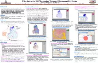
Active layer. Created buffer. Map Notes features. Selected feature. Save button. Using Interactive GIS Mapping in a Watershed Management DSS Design S. S. Panda, I. Chaubey, M. Matlock*
Download Presentation 
Using Interactive GIS Mapping in a Watershed Management DSS Design
An Image/Link below is provided (as is) to download presentation
Download Policy: Content on the Website is provided to you AS IS for your information and personal use and may not be sold / licensed / shared on other websites without getting consent from its author.
Content is provided to you AS IS for your information and personal use only.
Download presentation by click this link.
While downloading, if for some reason you are not able to download a presentation, the publisher may have deleted the file from their server.
During download, if you can't get a presentation, the file might be deleted by the publisher.
E N D
Presentation Transcript
Active layer Created buffer Map Notes features Selectedfeature Save button Using Interactive GIS Mapping in a Watershed Management DSS Design S. S. Panda, I. Chaubey, M. Matlock* *Respectively, Postdoctoral Research Associate, Assistant Professor, and Associate Professor, Biological and Agricultural Engineering Department, University of Arkansas, Fayetteville, AR 72701


More Related