Download

1 / 25
250 likes | 293 Views
Explore how ArcGIS was used to compare watersheds for flood plain mapping in Iron County, highlighting data collection methods, watershed delineation, DEM analysis, and floodplain determination.

E N D
NOTE: Authors do not claim responsibility for bad formatting in this presentation. If you desire to see the presentation in its full glory, go to Jeremy’s index page to download the presentation in Powerpoint 2007
Watershed Comparison Using ArcGIS for Flood Plain Mapping Kameron Ballentine Jeremy Jensen
Introduction • State of Emergency Declared in Iron County in 2005 • Due to Debris Flow and Other Flooding Taking Place • Concerns Arose About the Capacity of the Rivers and the Accuracy of the Flood Maps
Introduction • National Flood Rate Insurance Map (FIRM) Project was Underway • Several Rivers in Iron County had their Floodplains Remapped • Coal Creek and Parowan Creek Were 2 of the Rivers that had their Floodplains Remapped
Watershed Comparisons • Insufficient USGS Flow Data for Parowan Watershed to Create Flood Frequency Curves • Watersheds Compared Based on: • Size • Drainage Density • Available Flow Data • Springs • Soils • Precipitation • Snow Data
Data Collected • DEM and County Mosaic from AGRC Website • USGS – NWIS Streamflow Data • NHDPlus Stream and Watershed Data • Snotel Data (Not Found in the Area) • Precipitation Data (Not Found in the Area) from NOAA • Soils Data from USBR (Not Available in Area)
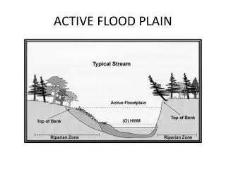
Watershed Delineation • Using Hillshade and Contours • Done by Hand • Check by Comparing USGS Gauging Site Upstream Watershed Area
Hydroseek http://cbe.cae.drexel.edu/search
Soils Data Natural Resources Conservation Service (NRCS) Has Soils Data for the State of Utah on its Webpage The Available Soil Data Did Not Cover Both of the Watersheds It Was Determined that Due to the Lack of Data that Soil Would Not be Compared
DEM Hillshade for Iron County • Hillshade Used to Better See Terrain • Two Areas in Question Shown
Clipped DEMs • “Extract by Mask” Command • Benefits of Clipping • Smaller File Size (500 MB vs 20 MB each) • Faster Processing • Easier to Visualize
NHD flowlines and hillshade • Hillshade to Visualize Terrain • NHDPlus Data Inserted and Clipped
Reconditioned DEMs • ArcHydro Tools • DEM and NHD Flowlines Used to Recondition • Prepared DEM for Processing
Preprocessing Results • Sinks Filled • Flow Directions Computed • Flow Accumulation Grid Calculated • Streams Defined and Segmented • Catchments Calculated and Processed
Watershed Comparisons • Coal Creek Watershed has: • 41% More Area • 35% More Average Flow • 75% More Springs Than the Parowan Watershed • Parowan Watershed has 28% More Drainage Density than the Coal Creek Watershed
Determining Parowan 100 yr Flood • Using Coal Creek as a Model the 100 yr Flood was Determined for Parowan • Comparison was Based on Size and Flow • 100 yr Flood for Coal Creek is 5500 cfs • 100 yr Flood for Parowan Creek is 4100 cfs
Determiningthe FloodplainThe Pre Hec-Ras Process • Need to Delineate River • River Delineation is Based on the Most Accurate Data Available (Aerial, DEM, Contours, etc.) • Need to Draw Cross Sections • Cross Sections Have Been Surveyed Previously and Need to be Drawn in ArcGIS
Determining the FloodplainThe Pre Hec-Ras Process • Need to Input the Bridge Cross sections • 1 Cross Section for the Bridge • 4 Cross Sections Along the River • Export to Hec-Ras • Before ArcGIS, this was Done by Hand
Determining the FloodplainModeling the River: Hec-Ras • Input All Survey Data Into Cross Sections and Structures (Bridges and Culverts) • Meet FEMA Guidelines on Critical Depths, Adverse Water Slopes, and Other Criteria
Determining the FloodplainMapping the Floodplain in Arc-Map • Export Hec-Ras Data (Water Surface Elevations, Top Width Distances) • Use Top Widths, Water Surface Elevations, Flow Data and Engineering Judgment to Delineate Floodplain
Conclusions • The Two Watersheds Were Hydrologically Similar • ArcMap is a Powerful Tool that Saves Time and Reduces Human Error