Download

1 / 19
200 likes | 246 Views
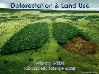
NASA's Land-Cover/Land Use Change Program: Landsat Activities. Garik Gutman NASA Headquarters Manager, LCLUC Program. Jeff Masek NASA Goddard Space Flight Center Landsat Project Scientist. Land-Cover/Land-Use Change Program.

E N D
NASA's Land-Cover/Land Use Change Program: Landsat Activities Garik Gutman NASA Headquarters Manager, LCLUC Program Jeff Masek NASA Goddard Space Flight Center Landsat Project Scientist
Land-Cover/Land-Use Change Program • LCLUC is an interdisciplinary scientific theme within NASA’s Earth Science program. The ultimate vision of this program is to developthe capability for periodic global inventories of land use and land cover from space, to develop the scientific understanding and models necessary to simulate the processes taking place, and to evaluate the consequences of observed and predicted changes • http://lcluc.hq.nasa.gov/
LCLUC Current Portfolio • ROSES-2010 • USPI 5-yr mid-term • Carbon Cycle mid-term • LCLUC new starts (Synthesis and Wetlands) • ROSES-2011 new starts • LCLUC Early Career Scientists • IDS Urban Impacts on Environment • ROSES-2012 • LCLUC Step-1 submitted (Industrial Forests Mapping and Synthesis) • ROSES-2007 5-yr mid-term • USPI • ROSES-2008 final stage • LCLUC • ROSES-2009 mid-term • LCLUC (Agriculture and Urban)
Global Land Survey Data Sets • Global cloud-free, geocorrectedd Landsat datasets centered on 1975, 1990, 2000, 2005, and 2010 • NASA-USGS Partnership • 1 scene per epoch at the peak of vegetation • 30-m global mosaic • For global assessments of land-cover change • Available at USGS archive • Paper describing GLS-2005 published in P&RS Journal • GLS datasets are complete and available for download via GLOVIS/EarthExplorer • Paper on assessment of GLS datasets is under revision for publication in RSE Journal Progression of fires scars in central Canada
Advanced Use of Mid-resolution Data • Fusing course- and mid-res data • Using all cloud-free pixels in the imagery • Fusing data from different mid-res sensors
Changes in Land Use: Fusing Moderate and Coarse Resolutions Landsat images for two periods Sep 2000 MODIS time series of Green Index for an abandoned irrigated area Iraq Sep 2006
Annual, Seasonal, Monthly Composited Mosaics Using All Clear Pixels by Compositing 2008 http://landsat.usgs.gov/WELD.php
Web-Enabled Landsat Data (WELD). Year: 2009 Alaska ~ 1,700 L1T acquisitions / year CONUS ~ 8,000 L1T acquisitions / year New tools and methods to process large data volumes from Landsat Roy SDSU 9
Global Landsat Processing Using High Performance Computing(7,281 input images, Monthly Composite May 2010) Roy SDSU 1.8km TOA true color browse, each pixel generated from 60 x 60 30m Landsat ETM+ pixels MODIS Land Sinusoidal Projection
Agricultural Monitoring Needs • Agricultural monitoring has emerged as a key priority for GEO • Global provisioning of food and water among most critical environmental issues in 21st century • Maize (2008) and wheat (2010) supply constrictions caused global price spikes and food insecurity • G20 Ag ministers requested creation of GEO-GLAM (Global Agricultural Monitoring initiative); ratified by CEOS (2011). • Crop assessments (type, condition) require ~weekly data @ <50m resolution • Currently no single remote sensing system satisfies this requirement • MODIS & MERIS can provide weekly phenology but at regional scales • Landsat can resolve individual fields, but only seasonally Hillsides in the Nilgiris being prepared for planting vegetables, shot by Rafeek Manchayil,
Single Landsat: 16-day Repeat Coverage since 1972 More frequent imaging is needed to maximize opportunity for cloud free observations particularly for rapidly changing phenomena: Fire, Flooding, Agriculture
Fusing data from landsat-like sensors: Land-cover phenology at 30 m • Red reflectance, near-infrared (NIR) reflectance, and NDVI values for individual fields from central Illinois during the first half of the 2006 growing season • Data are combined from Landsat-5, -7, ASTER, and IRS Courtesy of Feng Gao, ARC/USDA
Sentinel 2a,b - Landsat 7, 8: U.S. Longitude: -115.4 -89.4 Latitude: 35 43.5 • The picture shows the number of times the sensors for the Sentinel 2s, Landsat, and LDCM accessed areas on the ground over an 80 day period of time. • 26 accesses indicates a maximum revisit interval of ~3 days 2 hours • 55 accesses indicates a minimum revisit interval of ~1 day 11 hours The small number of blue colored bands (>50 accesses) indicate that the revisit interval over the majority of the region is on the order of 3 days.
Sentinel-2 and Landsat Fusion • Merging Sentinel-2 and Landsat data streams could provide < 5-day coverage required for Ag monitoring • Both sensors have 10-30m coverage in VNIR-SWIR • Satellite orbits complementary • Landsat-7 & Landsat-8 8 days out of phase • Sentinel-2a & 2b 5 days out of phase • Landsat and Sentinel-2 sun synch orbits precess relative to each other Landsat-7 Landsat-8 Sentinel-2a Sentinel-2b 2013 2014 2015 2016 2017 Global ~5 day coverage Global ~2-3 day coverage
Sentinel-2 Bands • 2 satellites (Sentinel 2a and 2b) • 290 km swath width • 7-year design life • Polar, sun-synchronous orbit (precessing relative to Landsat)
L-8 OLI vs S-2 MSI: Spectral Bands (nm) • * Cirrus Band added in 2001 to detect cirrus contamination in other channels • Coastal Band added in 2001 at request of ocean color investigators requiring higher resolution of coastal waters relative to MODIS and SEAWifs • Bandwidth refinements made in all bands to avoid atmospheric absorption features • Push-broom instrument architecture yields higher SNR • LDCM TIRS is a two band instrument => will enable atmospheric correction for a more accurate surface temperatures derivation for 100-m thermal imagesas compared to a single thermal band on Landsat-7 ETM+ but with 60-m resolution
SUMMARY • Landsat is a critical tool for Earth Systems Science in quantifying and understanding global LCLUC • The Landsat data record must be continued beyond Landsat 8 – what happens if Landsat 8 goes the way of Landsat 6 ! • Nobody questions why we need operational weather satellites - we need a similar ‘operational’ status for Landsat observations – with reduced mission costs and increasing the number of instruments flying/ready to fly • Need to incorporate Landsat-like data from non-US sensors, such as Sentinel-2 and other (CBERS, IRS, etc.) • The next Landsat (-8) in tandem with Sentinel-2 would be a good step towards the CEOS constellation paradigm • We need to continue to develop smart, automated tools to exploit the large volume, time-series of Landsat data