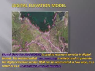
Digital Elevation Models
Digital Elevation Models. GLY 560: GIS and Remote Sensing for Earth Scientists. Class Home Page: http://www.geology.buffalo.edu/courses/gly560/. Creation of DEM’s. Conversion of contour lines Photogrammetry Satellite Stereo Radar Stereo Radar Inferometry Laser Altimetry.


Digital Elevation Models
E N D
Presentation Transcript
Digital Elevation Models GLY 560: GIS and Remote Sensing for Earth Scientists Class Home Page: http://www.geology.buffalo.edu/courses/gly560/
Creation of DEM’s • Conversion of contour lines • Photogrammetry • Satellite Stereo • Radar Stereo • Radar Inferometry • Laser Altimetry GLY560: GIS and RS
Conversion of printed contour lines • Existing map plates are scanned • Resulting raster is vectorized and edited contours are "tagged" with elevations • Additional elevation data are created from the hydrography layer (e.g. shorelines provide additional contours) • Algorithm is used to interpolate elevations at every grid point from the contour data GLY560: GIS and RS
Photogrammetry • Manually: an operator looks at a pair of stereophotos through a stereoplotter and must move two dots together until they appear to be one lying just at the surface of the ground • Automatically: an instrument calculates the parallax displacement of a large number of points (e.g. for USGS 7.5 minute quadrangles, the Gestalt Photo Mapper II correlates 500,000 points) • Correction of elevation from photographs: water bodies are assumed to be flat. GLY560: GIS and RS
Stereo Satellite • Two satellite passes are combined to get effective “stereo” view GLY560: GIS and RS
Stereo Radar • Works like photogrammetry but use radar wave instead. • Can be done from space or airborne with side-looking-airborne-radar (SLAR) • Can penetrate vegetation canopy GLY560: GIS and RS
Radar Interferometry • Use phase difference in two radar signals to measure elevation differences • Signals are from two receivers so called “synthetic aperture radar” or SAR. GLY560: GIS and RS
Laser Altimetry • Fly laser over area, and time reflection of laser. GLY560: GIS and RS
Available Resolutions of DEM GLY560: GIS and RS
7.5-minute USGS DEM • Resolution: 10 m or 30 m • Coverage: 7.5 x 7.5 min Quad (1:24,000) • Vertical Accuracy: 7 m GLY560: GIS and RS
10m and 30m DEM Availability http://mcmcweb.er.usgs.gov/status/dem_stat.html GLY560: GIS and RS
7.5-minute USGS DEM Data Classification Levels: • Level-1 Scanned from National High Altitude Photography (NHAP)/NAPP photography. A vertical RMSE of 7 meters is the desired accuracy standard. (Most 7.5” DEMs are Level-1) • Level-2 Processed or smoothed for consistency and edited to remove systematic errors. A RMSE of 1/2 contour interval. • Level-3 DEMs are derived from DLG data by incorporating hypsography (contours, spot elevations) and hydrography (lakes, shorelines, drainage). A RMSE of 1/3 contour interval. GLY560: GIS and RS
30-minute USGS DEM • Resolution: 2 arc seconds (~60m) • Coverage: 30x30 min block (½ 1:100,000) • Vertical Accuracy: 25 m GLY560: GIS and RS
1- degree USGS DEM • Resolution: 3 arc seconds (~100m) • Coverage: 1x1 deg block (½ 1:250,000) • Vertical Accuracy: 25 m GLY560: GIS and RS
“Seamless DEM” Data • Buy DEM from USGS already in mosaic form by National Mapping Program GLY560: GIS and RS
Global DEMs • GTOPO30 • Aster • Shuttle Mapping Program • IKONOS GLY560: GIS and RS
GTOPO30 • Resolution: 30-second (~1 km) • Coverage: 50 deg lat x 40 deg long • Vertical Accuracy: 30 m GLY560: GIS and RS
ASTER DEM • Advanced Spaceborne Thermal Emission and Reflection Radiometer • Off-Nadir pointing allows DEM • First international DEM of decent quality available. • Must request generation of DEM (slow turnaround) but FREE! GLY560: GIS and RS
Aster DEM • ASTER(30 m2/pixel) • GTOPO30 (1 km2/pixel) GLY560: GIS and RS