Download
1 / 26
260 likes | 392 Views
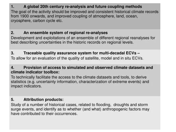
Objectives. Get high resolution climate re-analysis gridded data sets for research and climate analyses for all of Europe available and accessible with uncertainty measures Extend from EURO4M in several ways: Focus on RA and uncertainties and data services Longer time period

E N D
Objectives Get high resolution climate re-analysis griddeddata sets for research and climate analyses for all of Europe available and accessible with uncertainty measures Extend from EURO4M in several ways: • Focus on RA and uncertainties and data services • Longer time period • Resolution higher • More advanced Data Assimilation incl Ensemble • Different RA systems • More observations • Several ways of estimating uncertainties • Data services in a few different ways • Downstream services and User evaluation
SMHI in WP 2: 3D and 2D reanalysis 3D: HIRLAM - ERA on the borders and as a large scale constraint - 60 vertical levels - 22 km horizontal resolution 2D: MESAN - HIRLAM as first guess - Surface parameters - 5 km grid ERA Interim
Partners in UERRA Beneficiaryno1:SwedishMeteorologicalandHydrologicalInstitute(SMHI) Beneficiaryno2:MétéoFrance(MF) Beneficiaryno3:HetKoninklijkNederlandsMeteorologischInstituut(KNMI) Beneficiaryno4:TheMetOffice(MO) Beneficiaryno5:ClimaticResearchUnit,UniversityofEastAnglia(UEA) Beneficiaryno6:FederalOfficeofMeteorologyandClimatology(MeteoSwiss),subordinatedtoEidgenoessischesDepartementdesInnern(EDI) Beneficiaryno7:UniversityRoviraiVirgili(URV) Beneficiaryno8:NationalMeteorologicalAdministration(NMA-RO) Beneficiaryno9:EuropeanCentreforMediumRangeWeatherForecast(ECMWF) Beneficiaryno10:GermanMeteorologicalService-DeutscherWetterdienst(DWD) Beneficiaryno11:NorwegianMeteorologicalInstitute(MI) Beneficiaryno12:MeteorologicalInstituteattheUniversityofBonn(UB)
WP1 Data rescue Fill in gaps in the from 1950 data Sub-daily data Less than on monthly scales but know where to find Long term climate records from early 20th C Data development Quality controls – consistency in time – networks Homogenisation over time Improvements
WP1 Data rescue URV some 3.6 M records NMA-RO som 0.3 M Encourage to share national digitization efforts and get access to data Input to MARS at ECMWF Use in global and regional RA (WP2)
WP1 Continuing and extending the gridded data sets E-OBS and CRU Development of new methods, transformation for precip, multiple realisations => Uncertainties
WP2 Ensemble Data Assimilation Met Office EDA Dowscaled from ERA-CLIM2, ERA-20C 20 members at 36 km Higher resolution control, 12 km From 1970s, satellite era DWD / UBO Ensemble Kalman Filter EDA
WP2 deterministic models 11 km European 3D-VAR re-analysis 50 years Very demanding in CPU and data resource HARMONIE 2 model physics (ALADIN/ALARO) Vegetation cover ( cooperation MF) Surface analysis improvements – soil (Deterministic MO at 12 km and UBO ~ 6 km) 5 km European 2D MESCAN (MF) cooperation MESCAN developments – short runs – downstream from 11 km and 2 model physics 5 km European cloud MESAN analysis
Coupling the 2D surface analyses and a Surface Scheme 3D-Var Re-analyses at 10 km over Europe Downscaling SH, LE, snow depth, snow cover, soil moisture, Ts_lake 5 Km over Europe Observations 2D analyses at ~5 Km with MESCAN T2m, Rh2m, Wind, RR SW , LW SURFEX (V7): Surface Externalized (www.cnrm.meteo.fr/surfex) with a sophisticated snow scheme (Vionet et al. submitted) and the lake model: Flake (Mironov, 2008) Hydrological Model (TRIP)
EURO4M domain 5km Sub-regions not part of the project but may be carried out
Regional reanalysis ensemble COSMO on European CORDEX domain 847x823 grid points 40 vertical levels preferably at 6km resolution, otherwise 12km 10 – 20 ensemble members Hans-Ertel-Centre for Weather ResearchClimate Monitoring Branch
WP3 objectives Evaluation of regional re-analyses and assessment of their measures of uncertainty. Contribute to overall assessment of re-analyses for climate monitoring of extremes.
WP3 Internal spread in ensemble re-analyses -Internal spread in the sysems Differences between the re-analysis systems and down-scaled system -Some common systematic effects possible Validations against observation-gridded data sets E-OBS 25-50 km and varying data density (sometimes low) Depending on interpolation method Sub-regional high resolution other data sets! Alpine Nordic ...
WP3 Independent data sets: Space based CM-SAF ESA-CCI soil moisture, albedo, snow GPCC precipitation Sub-regional gridded data sets, Alpine and more (Nordic and possibly others) Downstream products: Hydrological models and discharge data
WP3 Constistency and dependency of different grids Effective resolution ? Climate trends ECVs and special climate features - extremes Can the RA reproduce these and use for climate montioring? Homogenity in time
WP3 => Quantification of uncertainty Statistical modelling, probabilistic approaches Time-space covariances Uncertainty as a function of scale
WP3 Early WS Common methodology and software decided on Statistical methods applied on all data sets and with gridded or high res gridded as a basis Minimum set of evaluation scores ensuring compatability Translate into language understood by users Evaluation WS
WP4 MARS and Web map service – ECMWF, KNMI ESFG services Hydrological downstream modelling Validation of re-analyses Climate Indicators (CIBs) User involvement and consultation
ECMWF expertise: Dataset definition • Definition of data sets • Re-Analyses (15, 40, Interim, CLIM, 20C), TIGGE, Observation Feedback Archive, EURO4M, ... • Homogeneity • Common terminology (parameter names, file names,…) • Common data format (format, units, …) • Definition of an agreed list of products (Parameters, Steps, levels, …) • Widen usage of data: multi-model inter-comparison, interoperability • Quality assurance • Standard formats: • Fields (GRIB) • Observations (BUFR), recently in ODB
WP5 Management Reporting SMHI project office
WP6 Coordination and scientific management