Download
1 / 18
180 likes | 292 Views
Explore El Salvador's efforts in disaster risk reduction and management through the Hydro-Meteorological Forecast Center’s services and early-warning systems.

E N D
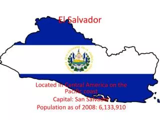
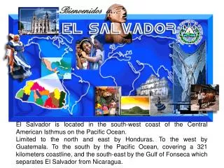
El Salvador is located in the south-west coast of the Central American Isthmus on the Pacific Ocean. Limited to the north and east by Honduras. To the west by Guatemala. To the south by the Pacific Ocean, covering a 321 kilometers coastline, and the south-east by the Gulf of Fonseca which separates El Salvador from Nicaragua.
Normal Annual Precipitation in El Salvador
Hydrological Gauging Stations and Flooding Areas in El Salvador 32 Meteorological Sta., 5 Telemetric 72 Pluviometer 30 Hydro Sta., 15 Telemetric
National Service of Territorial Studies El Salvador in spite of being a small country, it is frequently affected by natural phenomena as hurricanes, droughts and earthquakes that add to the chain of natural and environmental events, that they have meant in terms of losses and damages, a constant wear of the efforts of development and growth that El Salvador has come realizing. With the creation of the National Service of Territorial Studies it is tried to contribute to the prevention and reduction of the risk of disaster, for what it is of its competition the relative to the investigation and the studies of the phenomena, processes and dynamics of the nature, the environment and the society, that they have direct and indirect relation with the probability of occurrence of disasters and, therefore of losses and economic, social and environmental damages.
MENR GENERAL MANAGEMENT CONSULTATIVE EXTERNAL GROUP TECHNICAL COMMITTEE EXTERNAL ASSESSOR • Computer ServicesUnit • Maintenance & Engineering Unit Administrative Unit TCC TCC TCC TCC Geological Service Hydrological Service Meteorological Service Risk Management Service -Risk evaluation -Integration and reduction of risk -Spreading and training -Information -Specialized Studies -Information -Specialized Studies WQ GW SW Agromet OPC -Geology -Seismology -Vulcanology Hydrometeorological Forecast Center
Field Data CPH6 CPH1 CPH2 DDRGS PCBase2™ SHEF Server Switch CPH5 CPH4 CPH3 HydroBase™ NWSRFS SHEF Data Forecast Products Facilities and Equipment in the FC
Purpose of the Forecast Center • Early warning of serious flood conditions • Permits timely implementation of emergency measures to prevent or mitigate damages • Advance knowledge of future hydro-meteorological conditions (Long and Short Term Forecast) • Permits development of operation plans for the most efficient usage of available water resources • Data base • Provides basis for planning and design of future projects & for evaluating their economic & financial feasibility
THRESHOLD 0 INTERNAL STAGESOFPROCEDURES IN CASE OF HYDROMETPHENOMENA MONITORING & SURVEILLANCE THRESHOLD 1 PREWARNING THRESHOLD 2 WARNING THRESHOLD 3 ALERT THRESHOLD 4 EMERGENCY NOTES: Threshold: It refers to pre-set limits of stage on rivers Scheme of Procedures
Flow of Information from the Stations SENSORS CPH NWSRFS TRANSFER OF THE INFORMATION: SOCIAL NETWORK, INTERNET, TEL/FAX, RADIO, ETC.
Configuration of the NWSRFSLempa River Basin The catchment area of the Lempa river is about 18,246 square kilometers. For modeling purposes the river basin has been divided in 15 segments corresponding to each point of monitoring in real time. These points of monitoring include the four hydro power plants as well as hydrometric gauging stations. GO
Some of Our Products with NWSRFS Long term Forecast
Thank you! http://www.snet.gob.sv