Digital Elevation Model (DEM) Data Sources That You Can Get Easily
280 likes | 493 Views
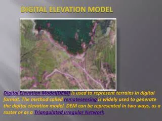
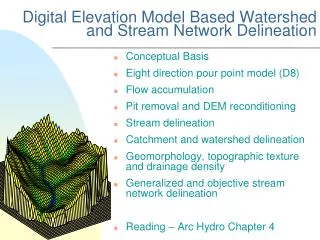
Digital Elevation Model (DEM) Data Sources That You Can Get Easily. Quadrilateral Data Structure. Grid cell resolution constant N-S but progressively finer E-W resolution from equator to pole. Geodetic latitude and longitude on WGS 84 ellipsoid (NAD 83). ETOPO2 Global DEM

Digital Elevation Model (DEM) Data Sources That You Can Get Easily
E N D
Presentation Transcript
Digital Elevation Model (DEM) Data SourcesThat You Can Get Easily
Quadrilateral Data Structure Grid cell resolution constant N-S but progressively finer E-W resolution from equator to pole Geodetic latitude and longitude on WGS 84 ellipsoid (NAD 83)
ETOPO2 Global DEM from National Geophysical Data Center
Technical Specifications (0,0) Row Major Order (10799,0) Worldwide Land And Sea Elevation Data In Meters (3.7x3.7km cells at equator) 2-byte signed integer data 5400 rows by 10800 columns 116,640,000 byte dataset (0,5399) (10799,5399)
Global Land One-km Base Elevation (GLOBE) DEM data from NGDC • 30” x 30” grid cells for the earth • Metric data for land areas, NoData • value (-500) given to sea areas
Spatial Resolution 0.93 x 0.93 km Cells at equator
Globe 30” x 30” grid cell data structure and tiling, format, and dataset size
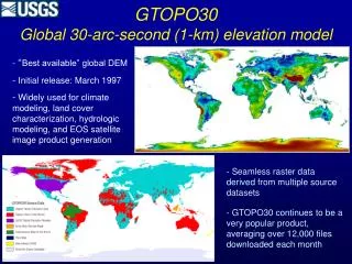
USGS GTOPO30 Global Land DEM • Integer Metric data for land areas, • NoData value (-9999) given to • sea areas. • 30” x 30” grid cells for the earth. • Single GRID dataset on ESRI • Data & Maps (21,600 rows x • 43,200 cols. [1.866GB file])
Shuttle Radar Topography Mission (SRTM) 3 arc-second (90m) data from USGS EROS
Each grid is divided into 1 degree tiles (1200 x 1200) for land areas Grid 2
Data are First • Reflective Returns • Data Completeness • Problems
Voids are Filled in ESRI Maps and Data 90m SRTM Dataset Data are Compressed From 34GB to 4.33GB
Shuttle Radar Topography Mission (SRTM) 1 arc-second (30m) data from USGS EROS
Each grid is divided into 1 degree tiles (1200 x 1200) for land areas Grid 4
SRTM Data are also available from The National Map Seamless Server
National Elevation Dataset (NED) from The National Map Seamless Server
National Elevation Dataset (NED) Data Structure • One-second grid cells for all • U.S. states except Alaska • 31m N-S resolution • 28m to 20m E-W resolution • NAD 83 lat./long. cell centers • from 25° to 50° N • Full dataset is about 60GB
Two-second Grid For Alaska • NAD 83 lat./long. cell centers • 62m N-S resolution • 38m to 21m E-W resolution • from 52° to 70° N
National Elevation Dataset (NED) Data Format and Tiling Scheme
National Elevation Dataset (NED) 1/3rd (10m) and 1/9th (3.3m) Arc-second Grids for Certain Areas from The National Map Seamless Server
You can buy the Data for each state In ArcGIS GRID format
Light Detection And Ranging (LIDAR) Data Uses a laser and sensor to transmit and receive pulses from reflected surfaces
Post processing of the return data produces a highly accurate DEM, typically with 1 meter spatial resolution. LIDAR DEMs available only for small local areas
USGS National Land Cover Data (NLCD) 2001 1”x1” Grid