Download
1 / 32
320 likes | 567 Views
MODIS Land Product Subsets: Remote Sensing Products for Field Sites (Collections 4 and 5). http://daac.ornl.gov/MODIS/modis.html. Bob Cook, Suresh Kumar, Susan Holladay, and Steve Margle ORNL DAAC Oak Ridge National Laboratory Distributed Active Archive Center Oak Ridge, Tennessee, USA.

E N D
MODIS Land Product Subsets:Remote Sensing Products for Field Sites (Collections 4 and 5) http://daac.ornl.gov/MODIS/modis.html Bob Cook, Suresh Kumar, Susan Holladay, and Steve Margle ORNL DAAC Oak Ridge National Laboratory Distributed Active Archive Center Oak Ridge, Tennessee, USA
Collaborators / Contributors • Steve Running and Faith Ann Heinsch (University of Montana) • Jeff Morrisette, Carol Davidson, Gary Fu, Gang Ye, and Nazmi El Saleous (NASA GSFC) • Calli Jenkerson, John Dwyer, and Tom Maiersperger (LP DAAC) • Crystal Schaaf, Mark Friedl, and Ranga Myneni (Boston University) • Jim Randerson (University of California-Irvine) • Alfredo Huete and Kamel Didan (University of Arizona) • Tim Wilson and Tilden Meyers (NOAA-Oak Ridge) ORNL DAAC User Working Group Member Coll. 5 Workshop, January 2007
Background • ORNL DAAC supports the biogeochemical dynamics and terrestrial ecology (field) research community • Field Campaigns, Land Product Validation, Ecosystem Modeling, and Model Archive • Community requested that we prepare MODIS Land Products in an easy-to-use format and size • To validate remote sensing products • To characterize field sites • For use in modeling studies • Collection 5 Subsets: in development, beta test version • Collection 4 Subsets: subsetted products available through Sept. 2008 Coll. 5 Workshop, January 2007
Preparing time series from remote sensing tiles Jan 03 Mar 03 Apr 03 Dec 02 Feb 03 NDVI Tiles for cropland site in Wisconsin Field Site Location * Images from USGS Global Visualization Viewer http://glovis.usgs.gov/ Coll. 5 Workshop, January 2007
First tool:MODIS Subsets for Selected Sites Data Formats Offered (Coll. 5) • ASCII – 7x7 km subsets • GeoTIFF – 25x25 km subsets Products are: 8-day, 16-day, or annual composite periods 1 km, 500 m, or 250 m resolution Documentation about subsets and links to detailed documentation of the MODIS products are provided 1,052 field sites for MODIS Collection 5 280 field sites for MODIS Collection 4
Multiple paths to access data (Coll.5) • FTP • Picklists • WebGIS* • Google Earth* • Picklists for GeoTIFFs* • *In development Coll. 5 Workshop, January 2007
Center Pixel Mean Value of Pixels Percent of Pixels that meet QC Criteria Beltsville Agricultural Research Center Surface Reflectance Band 1 Surface Reflectance Band 2 Coll. 5 Workshop, January 2007
NDVI Center Pixel Mean Value of Pixels Percent of Pixels that meet QC Criteria Beltsville Ag Center, MD EVI LAI fPAR Coll. 5 Workshop, January 2007
(Coll 4) Tim Wilson and Tilden Meyers, Ag. For. Met. In press Coll. 5 Workshop, January 2007
User can select and apply QC criteria, then display and download resulting files Coll. 5 Workshop, January 2007
Advanced Visualization:Grids of QC Bits Beltsville Agricultural Research Center, Maryland, LAI / fPAR, Year 2000 Day 113 LAI Filtered LAI SCF QC LAI Cloudstate LAI Deaddector LAI MODLAND QC fPAR Filtered fPAR SCF QC fPAR Cloudstate fPAR MODLAND QC fPAR Deaddector Coll. 5 Workshop, January 2007
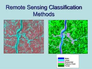
Subsets in GeoTIFF / WebGIS (Coll 4) MOD13A2, Band 1 Day 113, 2002 MODIS Land Cover Coll. 5 Workshop, January 2007
Subsets in GeoTIFF / WebGIS MOD13A2, Band 1 Day 113, 2002 GTOPO30 Layer Coll. 5 Workshop, January 2007
Second Tool: Custom Subsets for North America • User Working Group requested that we expand our subsetting to allow users to select • Site – not limited to pre-selected sites • Area – 7 x 7 km too small • Time period – instead of entire MODIS record Coll. 5 Workshop, January 2007
Second Tool (Coll. 4) • User selects center coordinates or site in North America, areal extent (up to 201 x 201 km), and period of interest • Processing of time series (selection of tiles, mosaicking, generating time series data file and graphs) takes 10 to 60 minutes for most products (depends on area, time period, and product) • URL with graphs and pointers to data files is emailed to user Coll. 5 Workshop, January 2007
Land Cover Visualization Coll. 5 Workshop, January 2007
Center Pixel Mean Value of Pixels Percent of Pixels that meet QC Criteria Time SeriesExample EVI Southern California
Center Pixel Mean Value of Pixels Percent of Pixels that meet QC Criteria Time SeriesExample EVI Southern California Mean (std dev) for pixels with same land cover as the center pixel (20 of 49 pixels) Center pixel = Woody Savannas Coll. 5 Workshop, January 2007
NIR-Reflectance EVI NDVI California Wildfire in September 2006 Source: MODIS Rapid Response Latitude [34.58] Longitude [-118.99] MODIS Horizontal Tile [8] Vertical Tile [5] August 2006 to October 2006 3km x 3km subset NIR reflectance Terra-MOD09A1 http://rapidfire.sci.gsfc.nasa.gov/ August 2005-November 2006 • Fire on September 17th 2006 caused • Reduction in NDVI,EVI • Reduction in NIR reflectance • Increase in SWIR reflectance etc August 2005-November 2006 NDVI and EVI – Terra–MOD13A2
Data Download Options • ASCII formatted file • Image data files in ASCII Grid format • QC-filtered data and statistics • Land cover data in ASCII Grid Format • Summary statistics for MODIS Land Products (ASCII) Coll. 5 Workshop, January 2007
Tool used in Undergrad / graduate classes • Alfred Huete, University of Arizona • Jim Randerson, UC – Irvine • David Roy, South Dakota State • “….extremely useful for scientists, students, lecture’s and also for PR.” Coll. 5 Workshop, January 2007
What's coming? • MODIS Collection 5 data for selected sites • Beta test now • Send us your comments • Global Subsetting Tool for Collection 5 • Create subsets of MODIS land products for any location on land anywhere on the globe • Quicker turn around time • Available Spring 2007 • Subsets of MODIS 4 NACP products • Smoothed LAI & fPAR and Vegetation Indices; Land surface water index • Tools • More GIS functionality • New visualization features Coll. 5 Workshop, January 2007
Questions? MODIS Subsets at ORNL DAAC • http://daac.ornl.gov/MODIS/modis.html Suresh Kumar: santhanavans@ornl.gov Bob Cook: cookrb@ornl.gov Coll. 5 Workshop, January 2007
Extra Slides Coll. 5 Workshop, January 2007
MODIS ASCII Subsets 18 Land Products from MODIS (Terra and Aqua) Pre-selected time period (2000 – present) and sites (n = 280 worldwide) Area of 7 x 7 km (ASCII) Area of 31 x 11 km (GeoTIFF) Data files stored on FTP One file per product-site File contains all dates and SDS* Upon-request visualization of single composite period grid or time series User can select and apply QC criteria, then display and download resulting files (Advanced Visualization) Tool For North America 18 Land Products from MODIS (Terra and Aqua) User selected time period and location (center pixel) for North America User selected area from 1 x 1 km up to 201 x 201 km Data files generated upon-request for NA ASCII file contains all SDS* and dates User receives URL via email (within an hour for most products) Contains data and visualizations Use the Science Team’s QC criteria MODIS Land Product Subsets (Collection 4) *SDS = Science Data Set Coll. 5 Workshop, January 2007
MODIS ASCII Subsets Data Flow MODIS Holding Area ORNL products in bundle? Unzip HDFs to holding area Yes HDF bundles (FTP push) for each HDF No MODAPS Discard ORNL products in HDF? Visualization Routines Yes (and to GDAL Tool) ASCII File Builder MRT (to binary file holding area) MODIS ASCII Subsets MODIS ASCII Subsets Bin to ASCII (Perl) Save to DB Coll. 5 Workshop, January 2007
MODIS Subsets in GeoTIFF • GeoTIFF image files • ORNL receives 31 x 11 km HDF-EOS files from the MODIS Processing Stream • Optimum size: can be reprojected from SIN to UTM to yield a 7 x 7 km subset anywhere on earth • ORNL uses GDAL Open Library tools to convert to GeoTIFF • Developed picklists to select sites / products / dates • Can be viewed in WebGIS Coll. 5 Workshop, January 2007
Acquisition and Processing of MODIS Tiles: Tool for North America ORNL DAAC LP DAAC Automatic FTP pull from Data Pool MODIS Data Pool MODIS Reprojection Tool: Conversion to Binary ORNL Code: Conversion to ASCII Inventory Inventory HDF Tiles ASCII tiles (per SDS) Temporary 1200 x 1200 km Files for User Interface Computer Resources Dedicated Server 10 TB RAID storage (capacity through 2009 for 1.5 TB/y) SDS = Science Data Set Coll. 5 Workshop, January 2007
Pixel Values Mean Value of Pixels Percent of Pixels that meet QC Criteria NDVI Albedo (Visible) Beginning to compile site data for comparison Yang Bai and Lianhong Gu (ORNL) Coll. 5 Workshop, January 2007
NDVI / EVI Time series for cropland in Wisconsin Location Dec 02 Jan 03 Feb 03 Mar 03 Apr 03 Location from Google maps Center Pixel Mean Value of Pixels Percent of Pixels that meet QC Criteria * Images from USGS Global Visualization Viewer http://glovis.usgs.gov/ NDVI EVI Year Year Coll. 5 Workshop, January 2007