WVDOT GIS Status Update and Phased Approach for Spatial Database Development
This document provides a comprehensive status update on the GIS initiatives within the West Virginia Department of Transportation (WVDOT), outlining the phased approach to enabling a spatially-enabled database for effective management of road infrastructure. It details the goals and responsibilities for GIS mapping, linear referencing systems, and the development of electronic straight-line diagrams. The update also highlights completed milestones, ongoing challenges, and the critical need for unique road IDs for asset inventory management, ensuring improved organizational efficiency across departments.

WVDOT GIS Status Update and Phased Approach for Spatial Database Development
E N D
Presentation Transcript
Status Update for Districts WVDOT GTI SECTION
AGENDA • Introduction. • Status Update. • How to Spatially Enable Database. • Challenges. • Conclusion.
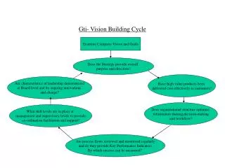
Phased Approach • Phase One - Research and Planning • Phase Two - Build Geometric Network • Phase Three - Design and Build Server • Phase Four - Application Development • Phase Five - Application Testing • Phase Six - Operation and Maintenance Diagram One
Goals & Responsibilities • GIS: Provide accurate base layers to support WVDOT’s geospatial needs. This will include the following: • Roads • Bridges • Intersections • Assets • Critical Infrastructure
Goals & Responsibilities • Mapping: Will be taking GIS base layers to create the following cartographic maps: • Official State Highway Map • State General Highway Map • State Functional Classification Map • State Highway Base Map • State Outline Map • District Maps • Regional Planning Councils Maps • State Traffic Flow Map • General Highway County Maps (55) • City Maps (187) • Urban Area Maps (26) • On-Demand Homeland Security Maps
Goals & Responsibilities • Straight Line Diagrams: This program will be electronic and will require less time to update. • Linear Referencing System: This is the procedures for determining and retaining a record of specific points or segments along a highway. The system includes the location reference methods together with the procedures for storing, maintaining, and retrieving location information about points and segments on the roads.
WVDOT GIS Status Update • Working to Complete the Location Referencing Model. • Completed Year One of GIS Training Program. • Completed Website for GIS Section. • Completed Fueling Location Book. • Created Geo-spatial Data Policy.
WVDOT GIS Status Update December 2006 4155 Miles September 2007 13,509 Miles
Cont: WVDOT GIS Status Update • Created Web-based Applications • STIP • Proto-type Crash Analysis • Port Locations Other Information Systems evaluated and considered for GIS integration; • Road Inventory Log (RIL) • Project Tracking System (PTS) • Average Daily Traffic (ADT) • Pavement Management • Document Management • Coal Resource Tracking Systems (CRTS)
Cont: WVDOT GIS Status Update • GIS Maps Developed: • Project Tracking System • Port Locations • Fuel Locations • HPMS Sample Locations • Homeland Security
Cont: WVDOT GIS Status Update Created Road Naming Committee • for standards on development of road naming and classification. Created a subcommittee to establish a plan for a relational database for RIL. • Consisting of database administrators and engineers to make recommendations for standards.
State - Route – Mile log Machine Link to GPS Survey Stationing Station 2+34.5 Offset from asset County-Route–Segment-Offset Traffic Section Street Address Linear Referencing Methods Sign State Line Roughness Bridge Pothole Barrier / Guardrail County Line Accident Traffic Street Intersection Complaint
Interchange with ramps Ramp Identification 4010640017 Route Identification 4010640000
Interchange with ramps Ramp Identification with Direction 4010640017WB Route Identification 4010640000WB
Interchange with ramps Ramp Identification with Direction and Number 4010640017WB46 Ramp Identification with Direction and Number 4010640017WB45
EXISTING PROPOSED NEW
Conclusion • All roads owned by the WVDOT should have a unique ID, that all departments and sections should utilize. • This unique ID should be a key added to each database with the same formatting. • A relational database needs to be established for the Road Inventory Log. • Identify additional fields that need to added and collect on Road Inventory Log. • District offices need GIS personnel to start collecting asset inventory such as culvert, drains, etc.