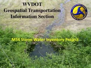
WVDOT Geospatial Transportation Information Section
230 likes | 571 Views
WVDOT Geospatial Transportation Information Section. MS4 Storm Water Inventory Project. Program Planning & Administration Division. Geospatial Transportation Information (GTI) Section. Highway Data Services Unit. GIS Unit. - Geospatial Data Management -Geospatial Services.

WVDOT Geospatial Transportation Information Section
E N D
Presentation Transcript
WVDOTGeospatial Transportation Information Section MS4 Storm Water Inventory Project
Program Planning & Administration Division Geospatial Transportation Information (GTI) Section Highway Data Services Unit GIS Unit - Geospatial Data Management -Geospatial Services • Roadway Inventory Log • -Roadway Statistics • -Public Certified Mileage
MS4 Project Background • Updates to the Clean Water Act required additional attention to pollution from storm water • Water Pollution Control Permit with WVDEP • Requires Storm Water Inventory Map • Requires regular inspections
WVDOH Districts and Municipal Separate Storm Sewer Systems (MS4) MS4 Areas defined by 2000 Census Urbanized Areas
Project Background • Environmental Coordinators in each District Office given task of meeting permit requirements. • Several independent • projects were started. • No standard methods or • data items.
GTI Involvement • It was determined that GIS would offer the best solution to meet the requirements. • The GTI Section • was brought on • to assist in project • development.
Project Development • Standards • Common format and Attributes • Coordinate System • Collection Methods • Processing Methods
Project Development • Trimble Juno with • Terrasync field data • collection software • was chosen. • Two purchased for • each district.
Rating Systems • Features evaluated on two rating systems • MS4 environmental rating • Maintenance rating
District Workflow • Utilize GIS map to plan field work • Collect GPS data • Post-Process GPS data • Submit Shapefiles to GTI • District Environmental Coordinators conduct follow up procedures on inspection results. • MS4 Features are inspected every 3 years.
GIS Workflow • Shared project folder created on server for moving data • Exported shapefiles and pictures from districts moved to the shared folder • Data quality is verified • Shapefiles are loaded into MS4 Feature Class in SDE • ArcGIS Server Map Service • Pictures loaded to web server
Project Status • Pilot project was conducted in one district to verify procedures. • Summer interns are utilized for field work • 5,000 features collected the first summer • 9,000 features collected the following summer • About 85% of all MS4 areas have been inventoried • The remaining 15% are in two districts with the largest urbanized areas • Other districts will be conducting inspections this year
Interactive Map http://gis.wvdot.com/MS4/MS4.html
Future • Testing currently underway to deploy the project as ArcGIS Mobile Application to simplify the inspection process. • Enhancement of the web map to allow district environmental coordinators to edit attributes.
Spinoff Projects • Pipe/Culvert inventory in non-ms4 areas • Small Bridge inventory • Rail Crossing inventory • Land Slide inventory
MS4 Stormwater Inventory • Questions? • Kyle Weatherholt • (304) 558-7434 • Kyle.S.Weatherholt@wv.gov