Download
1 / 38
380 likes | 536 Views
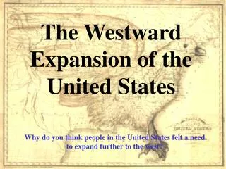
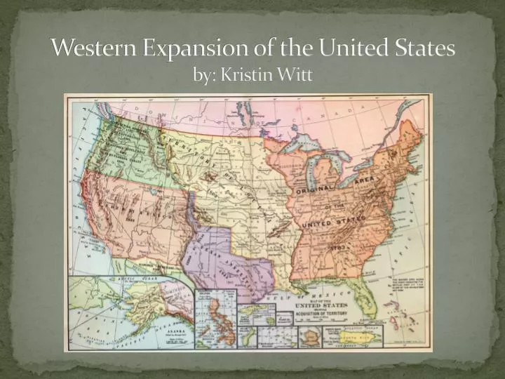
Western Expansion of the United States by: Kristin Witt. US 1.8

E N D
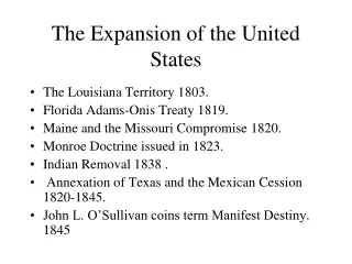
US 1.8 • The student will demonstrate knowledge of westward expansion and reform in America from 1801 to 1861 by describing territorial expansion and how it affected the political map of the United States, with emphasis on the Louisiana Purchase, the Lewis and Clark expedition, and the acquisitions of Florida, Texas, Oregon, and California.
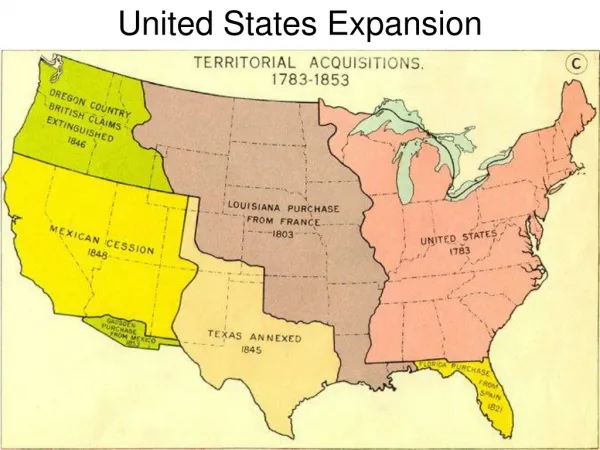
The United States Prior to 1801….. • The United States prior to 1801 consisted of the original 13 colonies and the territory from the Appalachian Mountains to the Mississippi River that was acquired after 1783 with the signing of the treaty of Paris.
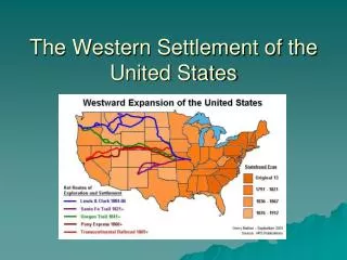
Between 1801 and 1861, exploration was encouraged as America underwent vast territorial expansion and settlement. • New Territories added to the United States between 1801 and 1861… • Louisiana Territory • Florida • Texas • Oregon • California
The Louisiana Purchase…. • In 1803 Thomas Jefferson purchased this territory from France for 15 million dollars. This purchase doubled the size of the United States overnight.
The Louisiana Purchase…. Purchase Treaty Signature Stamp
The Louisiana Purchase.. • Thomas Jefferson hired Meriwether Lewis and William Clark to explore this newly purchased territory. The expedition lasted two years and covered the area of land from the Mississippi River to the Pacific Ocean.
Let’s Journey Across America…. …with Lewis and Clark
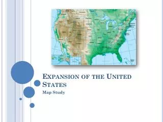
17 11 7 6 13 12 4 8 10 14 15 5 9 16 18 2 19 1 3 This is a copy of what your map of the United States looks like.As we journey across America with Lewis and Clark, put a star on top of each number when you are given directions to do so on each new slide. When your map is complete, you can draw a line connecting the stars – RED for the journey westward and BLUE for the journey eastward (home).
1 Place a star over #1 on your map! #1-Presidential Mission…. In 1803 President Jefferson asked Capt. Meriwether Lewis to form a groupthat would explore the newly purchased Louisiana Territory.
1 2 Place a star over # 2 on your map! #2 -Preparations…….. In early 1803 Capt. Lewis arrived in Philadelphia to study many skills he would need to complete his mission. As preparations were made, Lewis selected his co-captain for the expedition, Capt. William Clark.
1 2 3 Place a star over #3 on your map! #3 -Confirmation Lewis and Clark set out on their westward journey with a group of men they called the Corps of Discovery. The Corps began its historic journey at the mouth of the great Missouri River.
1 2 3 4 The expedition settled for the winter near the mouth of the Knife River in North Dakota in late October 1804. There they employed a trader named Toussaint Charbonneau. Lewis later wrote that he was "a man of no particular merit," but he brought along a wife named Sacagawea. She proved to be a great asset. Place a star over #4 on your map! #4 - Wintering with the Mandans
1 2 3 4 5 Place a star over #5 on your map! #5 – Turning Point At FortMandan on a subzero February day in 1805, Sacagawea gave birth toa son, Jean Baptiste Charbonneau. On April 7 with the baby only weeks old, the Corps resumed its journey.
1 2 3 4 5 6 Some days the Corps covered 25 miles. The expedition encountered grizzly bears, which Lewis and Clark usually called "white bears,” bighorn sheep, wolves, coyotes, beaver, geese, ducks, eagles, swans, elk, buffalo, and antelopes. The Corps was amazed at the rolling, treeless plains! Place a star over #6 on your map! #6 – High on the plains..
1 2 3 4 5 6 7 Place a star over #7 on your map! #7 – Decision at the Marias… On June 2, 1805, the Corps arrived at a major fork in the river. The maps and information from Indian scouts hadn’t mentioned the fork. Lewis and Clark had to decide which course was the true Missouri River.
1 2 3 4 5 6 7 8 Place a star over #8 on your map! #8 – Majestically Grand Scenery… Lewis arrived at the Great Falls of the Missouri River on June 13, 1805, anticipating an easy, one-day journey. Instead, he discovered four more waterfalls, complicating his plan. Clark called this the most perilous part of their journey. They had to spend a great deal of time hewing out two cottonwood dugouts to continue on their way.
1 2 3 4 5 6 7 8 9 Place a star over #9 on your map! #9 – A Critical Landmark .. The members of the expedition were desperate to cross the Rocky Mountains before winter. Steadily, they navigated a gap that Lewis called the “Gates of the Mountains.” Sacagawea told Lewis that she was starting to recognize the territory and that her people were not far. This lifted his spirits tremendously.
1 2 3 4 5 6 7 8 9 10 Place a star over #10 on your map! #10 – Over the Divide… Lewis was determined to find the Shoshone Indians. After navigating three rivers, Lewis scouted the area with three companions. They relied on Sacagawea’s memories as a young girl. They soon spotted a lone Indian and the next day reached the Continental Divide.
1 2 3 4 5 6 7 8 9 10 11 Place a star over #11 on your map! #11 – Shoshone, Salish and Nez Perce The Shoshone Indians, Sacagawea’s people, were amazed by the appearance of Clark’s black slave, York, and Lewis’ black Newfoundland dog, Seaman.
1 2 3 4 5 6 7 8 9 10 12 11 Place a star over #12 on your map! #12 – Through the Gorge.. The expedition had to traverse some of the roughest terrain of their journey west of the Rocky Mountains. They had to cross the Cascades, which contained extremely high peaks such as Adams, Jefferson, St. Helens, and Hood. Then came the precipitous Columbia Gorge!
1 2 3 4 5 6 7 8 9 10 12 13 11 Place a star over #13 on your map! #13 – And Down to the Sea… As the Corps emerged from the Columbia Gorge, it spent two horrible weeks pinned down by storms near the Pacific Ocean. Finally, they found a site for their winter home in modern-day Astoria, OR, on the Netul River.
7 12 10 9 8 6 14 4 3 2 1 13 5 11 Place a star over #14 on your map! #14 – Planning Ahead.. Once the expedition reached the Pacific, the captains had to plan and organize the return trip. The members planned to split into two main groups and reunite at the junction of the Missouri and Yellowstone rivers.
1 7 2 3 4 5 9 6 10 12 13 14 15 8 11 Place a star over #15 on your map! #15 – More Indian Aide … Lewis and Clark again depended upon help and advice from Indians to get them to the mouth of the Clearwater River. They traded to get their horses back, and with two Nez Perce guides to help them, they set out to again conquer the Rocky Mountains.
9 15 14 13 12 10 8 16 6 5 4 3 2 1 7 11 Place a star over #16 on your map! #16 -Clark on the Roche Jaune Clark spent very little time exploring the Roche Jaune (French for Yellow Stone). He climbed a massive gray rock 25 miles east of modern Billings, MT, called it "Pompy's Tower" (Pomp was Clark’s nickname for the infant son of Sacagawea), and carved his name on its side. The etching is one of the few surviving pieces of physical evidence of the expedition.
9 17 7 1 2 3 4 6 5 16 10 12 13 14 15 8 11 Lewis took three men to explore the source of the Marias River. When it became clear the Marias branches did not go as far north as Lewis had hoped, he called their camp site Camp Disappointment. Then Lewis and the men met their first Blackfeet Indians. The encounter ended in a fight, with two Blackfeet dead and Lewis and his men fleeing back to the Missouri. Place a star over #17 on your map! #17 - Camp Disappointment…
10 8 1 2 3 4 5 7 6 18 12 13 14 15 16 17 9 11 Fast Facts Pushing hard, the Corps neared St. Louis. The captains paid Charbonneau $500.33 when he left the Corps in the Mandan villages. Although Sacagawea received nothing, Clark acknowledged her role in a letter to her husband. When they landed in St. Charles, the group officially ended their “journey of discovery.” Place a star over #18 on your map! #18 - Nearing Home….
1 18 17 2 3 4 5 6 8 7 10 19 12 13 14 15 16 9 11 Place a star over #19 on your map! #19 - Discovering Lewis and Clark Few appreciated the efforts of the Corps of Discovery when it returned. Sgt. Patrick Gass’ diary was the first account of the journey printed, in 1807. In 1814 Clark made sure the "official" two-volume account was printed after Lewis's death in 1809. Only 2,000 sets were printed. Today, history heralds the expedition as a journey that changed the history and fate of the United States.
The Florida territory was acquired in 1819 when the United States signed a treaty with Spain. • Indians were crossing the border between Florida (owned by Spain) into Georgia, (which was part of the United States) and attacking our citizens. James Monroe, who was President of the United States at the time gave Spain an ultimatum. He told them to either send troops into Florida to keep Indians from coming into the United States, or give Florida to us. Spain was having it’s own conflicts in South America at this time, and could not send troops; therefore, decided to give Florida to the United States. Florida…
Texas… • This land was owned by Mexico before it became in independent republic and later joined the United States of America in 1845.
Texas…. • How it was acquired…. Americans began to settle in the southwestern territory owned by Mexico. Before long, the American settlers, who outnumbered those from Mexico, fought for and won independence from Mexico. This battle is known as “The Alamo” and took place in San Antonio Texas. This new land became the Republic of Texas and joined the United States several years later in 1845, as the 28th state to join the union.
Oregon Territory… • This land included present day Oregon, Washington, Idaho and portions of Montana and Wyoming. For many years the United States and Great Britain shared ownership of this land. As more American settlers arrived in this territory, the U.S. informed Great Britain that joint ownership would no longer be considered. Diplomatic discussions began and in 1846 a treaty was signed handing over the territory completely to the United States.
The California Territory… • California Territory – also known as the Mexican Cession. • America fought in the Mexican War and won, acquiring this land in 1848.
The California Territory (Mexican Cession)… • After the U.S. offered Texas statehood, relations with Mexico worsened. Four months later, fighting along the Rio Grande River led to war with Mexico. During the two years that followed, settlers in the territory of California revolted against Mexican rule. Within months, a treaty was signed and American troops took possession of California and the vast southwest territory.
The End To be continued…..