Download
1 / 18
260 likes | 627 Views
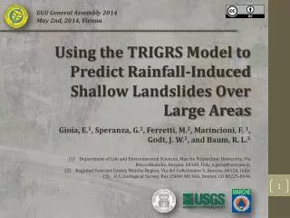
EGU General Assembly 2014 May 2nd, 2014, Vienna. Using the TRIGRS Model to Predict Rainfall-Induced Shallow Landslides Over Large Areas. Gioia, E. 1 , Speranza, G. 2 , Ferretti, M. 2 , Marincioni, F. 1 , Godt , J. W. 3 , and Baum , R. L. 3

E N D
EGU General Assembly 2014 May 2nd, 2014, Vienna Using the TRIGRS Model to Predict Rainfall-Induced Shallow Landslides Over Large Areas Gioia, E.1, Speranza, G.2, Ferretti, M.2, Marincioni, F. 1, Godt, J. W.3, and Baum, R. L.3 Departmentof Life and EnvironmentalSciences, Marche PolytechnicUniversity, Via BrecceBianche, Ancona, 60100, Italy, e.gioia@univpm.it; RegionalForecast Center, Marche Region, Via del ColleAmeno 5, Ancona, 60126, Italy; U.S. GeologicalSurvey, Box 25046 MS 966, Denver, CO 80225-0046
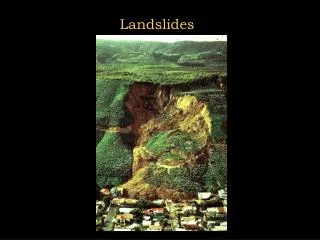
Introduction 99% municipalitiesaffected • (picturescourtesy of the Marche CivilProtection) USING THE TRIGRS MODEL TO PREDICT RAINFALL-INDUCED SHALLOW LANDSLIDES OVER LARGE AREAS • (Ministry for the Environment, Land and Sea - Report 2008)
Introduction EVENT USING THE TRIGRS MODEL TO PREDICT RAINFALL-INDUCED SHALLOW LANDSLIDES OVER LARGE AREAS
EMPIRICAL MODELS • (STATISTICAL) • PHYSICAL MODELS • (DETERMINISTIC) Introduction • Antecedentrainfall (A) ; • Rainfallintensity (I) ; • Rainfallduration (D) : • Probability • Hydrologicalfeatures; • Hydrogeologicalfeatures; • Geomorphologicalfeatures; • Geotechnicalfeatures; • Structuralfeatures. USING THE TRIGRS MODEL TO PREDICT RAINFALL-INDUCED SHALLOW LANDSLIDES OVER LARGE AREAS LANDSLIDES FORECAST
Introduction TRIGRS (Transient Rainfall Infiltration and Grid-based Regional Slope Stability) USING THE TRIGRS MODEL TO PREDICT RAINFALL-INDUCED SHALLOW LANDSLIDES OVER LARGE AREAS
Study area USING THE TRIGRS MODEL TO PREDICT RAINFALL-INDUCED SHALLOW LANDSLIDES OVER LARGE AREAS THE POST-OROGENIC COMPLEX OF THE ESINO RIVER BASIN
Data collection USING THE TRIGRS MODEL TO PREDICT RAINFALL-INDUCED SHALLOW LANDSLIDES OVER LARGE AREAS LANDSLIDES (82) OCCURRED DURING THE PERIOD 1990-2012
Data collection USING THE TRIGRS MODEL TO PREDICT RAINFALL-INDUCED SHALLOW LANDSLIDES OVER LARGE AREAS RAIN GAUGES USED FOR THE STUDY
Data collection USING THE TRIGRS MODEL TO PREDICT RAINFALL-INDUCED SHALLOW LANDSLIDES OVER LARGE AREAS LANDSLIDES TEXTURE CLASSES
Data collection USING THE TRIGRS MODEL TO PREDICT RAINFALL-INDUCED SHALLOW LANDSLIDES OVER LARGE AREAS BOX PLOT CHARTS OF CENTRAL TENDENCIES
Method STEP 1: TRIGRS calibration USING THE TRIGRS MODEL TO PREDICT RAINFALL-INDUCED SHALLOW LANDSLIDES OVER LARGE AREAS SETTINGS
Method STEP 1: TRIGRS calibration STEP 2: Outline test cases, choose the rainfall event, select the rain gauge and the rainfall intervals USING THE TRIGRS MODEL TO PREDICT RAINFALL-INDUCED SHALLOW LANDSLIDES OVER LARGE AREAS SETTINGS
Method STEP 1: TRIGRS calibration STEP 2: Outline test cases, choose the rainfall event, select the rain gauge and the rainfall intervals STEP 3: Evaluate an “Antecedent Water Index” USING THE TRIGRS MODEL TO PREDICT RAINFALL-INDUCED SHALLOW LANDSLIDES OVER LARGE AREAS SETTINGS
Method STEP 1: TRIGRS calibration STEP 2: Outline test cases, choose the rainfall event, select the rain gauge and the rainfall intervals STEP 3: Evaluate an “Antecedent Water Index” STEP 4: Construct input grids of slope from a 20m DEM, property zones, rainfall input, soil depth and water table depth USING THE TRIGRS MODEL TO PREDICT RAINFALL-INDUCED SHALLOW LANDSLIDES OVER LARGE AREAS SETTINGS
Results USING THE TRIGRS MODEL TO PREDICT RAINFALL-INDUCED SHALLOW LANDSLIDES OVER LARGE AREAS OCTOBER 1996 CASE STUDY
Results USING THE TRIGRS MODEL TO PREDICT RAINFALL-INDUCED SHALLOW LANDSLIDES OVER LARGE AREAS RECEIVER OPERATING CHARACTERISTICS (ROC) ANALYSIS
Conclusion • Wepresented an innovative methodology for the application of a physical model (TRIGRS) for rainfall-induced shallow landslides forecasting over broad areas. • TRIGRS well predicts the instabilities, thus can be used to build an accurate susceptibility map; • Rainfall-induced landslides over large regions may be predicted even where geotechnical and hydraulic properties data as well as temporal changes in topography or subsurface conditions are not available. USING THE TRIGRS MODEL TO PREDICT RAINFALL-INDUCED SHALLOW LANDSLIDES OVER LARGE AREAS