Soils and Microclimate
Soils and Microclimate. Obtaining Soils and Microclimate data How much N in ecosystems?. Microclimate and SOILS. Characterizing the Physical Environment. Focus is LOCAL, not global or regional. What are the site properties? What site properties might constrain management activities?

Soils and Microclimate
E N D
Presentation Transcript
Soils and Microclimate Obtaining Soils and Microclimate data How much N in ecosystems?
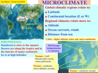
Microclimate and SOILS Characterizing the Physical Environment Focus is LOCAL, not global or regional What are the site properties? What site properties might constrain management activities? Are there sensitive areas that might be changed by management? How can you obtain and use this info?? Reading: Anderson and Ingram, Tropical Soil Biology and Fertility: A Handbook of Methods, Chap. 2: Site Description available as electronic reserve on the web page Also on Library Reserve: Brady and Weil, Elements of the Nature and Properties of Soils 2
Washington Soil Series 4 http://remotesens.css.wsu.edu/washingtonsoil/
Many counties in the U.S. have a Soil Survey produced by Natural Resources Conservation Service (NRCS) 6
Collecting Soil Information Soil Surveys Maps Profile descriptions Tables on soil properties: physical, chemical, engineering, land capabilities, plant growth 7
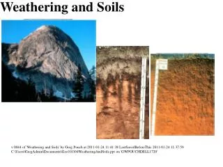
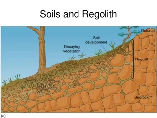
ALDERWOOD SERIES The Alderwood series consists of moderately deep to a cemented pan, moderately well drained soils formed in glacial till. Alderwood soils are on glacially modified foothills and valleys and have slopes of 0 to 65 percent. The average annual precipitation is about 40 inches, and the mean annual temperature is about 50 degrees F. TYPICAL PEDON: Ap--0 to 7 inches; very dark grayish brown; gravelly ashy sandy loam; moderate fine granular structure; slightly acid (pH 6.2). (3 to 7 inches thick). Roots? Bs1--7 to 21 inches; dark yellowish brown; very gravelly ashy sandy loam; weak medium subangular blocky structure; slightly acid (pH 6.2). Bs2--21 to 30 inches; dark brown; very gravelly ashy sandy loam; weak medium subangular blocky structure; slightly acid (pH 6.2). (Combined Bs1 and Bs2 horizons are 15 to 30 inches thick) 2Bs3--30 to 35 inches; 50% olive/yellowish brown and 50% dark greyish brown; very gravelly sandy loam, some cemented fragments, massive; moderately acid (pH 6.0). (0 to 15 inches thick) 2Bsm--35 to 43 inches; dark grayish brown cemented layer that crushes to very gravelly sandy loam; massive; 40 percent pebbles; moderately acid (pH 6.0). (5 to 20 inches thick) 2Cd--43 to 60 inches; grayish brown compact glacial till that breaks to very gravelly sandy loam; massive; extremely hard; 40 percent pebbles; moderately acid (pH 6.0). 10
Some Climate and Soil Survey Websites Climate data Snotel - snow, water equivalent, air temps http://www.wcc.nrcs.usda.gov/snow/ National Climatic Data Center (NCDC) - NOAA satellite service http://gis.ncdc.noaa.gov/maps// National Weather Service Forecast Office http://www.wrh.noaa.gov/sew/ Soils data Natural Resources Conservation Service (NRCS) Soil Surveys by State http://soils.usda.gov/survey/printed_surveys/ NRCS - Snohomish County Survey http://soildatamart.nrcs.usda.gov/Manuscripts/WA661/0/wa661_text.pdf NRCS - Washington state Soil Surveys http://soils.usda.gov/survey/printed_surveys/state.asp?state=Washington&abbr=WA WA Soil Survey Reports http://www.or.nrcs.usda.gov/pnw_soil/wa_reports.html 19
Environmental and Resource Assessment Uses Critical Area Ordinances Environmental Impact Statement Endangered Species Act Habitat Conservation Plan Forest Certification Vegetation Management Plan Non-Industrial Private Forestland owner Forest Stewardship Plan 20
Ecosystem Nitrogen(kg/ha) How much resource? Hint: Consider % and mass!! 21