Download
1 / 1
10 likes | 214 Views
Center for Embedded Networked Sensing. Assessing Ground Water – Surface Water Exchanges in a Complex River Regime. Henry Pai, Jason C. Fisher, Sandra R. Villamizar , Christopher Butler, Alexander A. Rat’ko, Thomas C. Harmon School of Engineering, UC Merced.

E N D
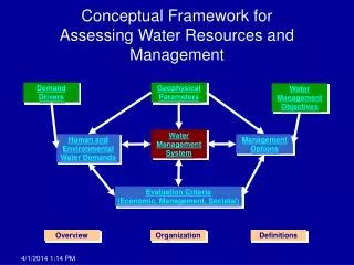
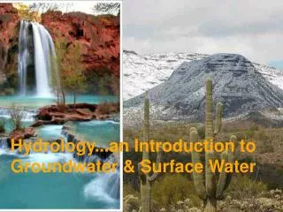
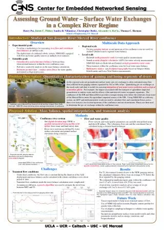
Center for Embedded Networked Sensing Assessing Ground Water – Surface Water Exchanges in a Complex River Regime Henry Pai,Jason C. Fisher,Sandra R. Villamizar,Christopher Butler,Alexander A. Rat’ko,Thomas C. Harmon School of Engineering, UC Merced Introduction: Studies at San Joaquin River-Merced River confluence Overview Multiscale Data Approach • Experimental goals • To refine a methodology for measuring river flow and constituent mass balances at sub-km scale. • The deployment of a tethered robotic system, NIMS RD,equipped with flow and water quality sensors atmultiple river transects. • Scientific goals • Calculate flow and solute mass balances between three observational transects within the river confluence zone. • Perform a sensitivity analysis on the mass balance calculation. • Delineate ground water – surface water fluxes for water quality and related ecological processes. • Regional scale • Existing gauging stations at and upstream of the confluence zone are used for method validation and a regional water balance. • Local scale • Hydrolab multi-parameter sonde for water quality measurements. • Sontek acoustic Doppler velocimeter (ADV) for water velocity measurements. • NIMS RD delivers Hydrolab and Sontek for high granularity raster scans. • Three transects within the confluence zone for local water mass balance. • Bathymetric surface and floodplain topography based on Valeport Midas EchoSounder and Leica Total Station measurements. Problem Description:Quantitative characterization of gaining and losing segments of rivers At the regional scale net groundwater-surface water (gw-sw) exchange is often estimated using flow data collected from gauging stations separated by 10s to 100s of km. Quantifying gw-sw exchanges at the reach scale (sub-km) is useful for assessing mitigation of non-point source pollution and ecological restoration efforts. For example, the impact associated with the transport of agriculture impacted groundwater to surface water and the effects of the nutrient rich water on aquatic organisms. The confluence of the SJR and Merced River provides a unique mixing zone where the relatively clean water of the Merced River enters the agriculture impacted waters of the SJR. Using NIMS RD as a delivery system, an ADV and multi-parameter sonde are used to calculate flow and constituent fluxes across three river transect, two located upstream of the confluence and one downstream. Fluxes are then used to determine the gw-sw exchange within the confluence zone. ↑ Upstream view of Merced River flowing from left and San Joaquin River (SJR) from right. NIMS RD shown delivering sensor package downstream of confluence. Proposed Solution:Mass balance, spatial interpolation, andtransient analysis Methods • Confluence river system • Site digital elevation map, DEM, is spatially interpolated using multilevel B-splines from sonar and land survey data. • River cross-sections are defined by water surface elevations and ground surface elevations along a transect. • Flow and water quality • Flow velocity and water quality parameters are spatially interpolated using multilevel B-splines. The volumetric flow rate and the constituent flux is calculated using a element based technique. ↑ Regional site with gauging stations denoted by dots and corresponding river network diagram. Interpolated DEM of river confluence zone with transect locations. → ↑ Left 3 plots show interpolated contour of flow velocity. Right 3 plots show interpolated contour for the specific conductivity, a water quality parameter measured by the Hydrolab multi-paramter sonde. Challenges Results • Transient flow conditions • Under ideal conditions, the flow rate is constant during the duration of the field deployment and mass balance can be calculated with certain confidence over a short period of time. • Transient flow conditions made the mass balance calculation more complicated. • Assuming no diffusion, a genetic algorithm was used to estimate the travel time between MST and T2. • For T1, the transect located closest to the NEW gauging station, the calculated volumetric flows were on average 4.3% below the flow reported by the gauging station. • The estimated groundwater input, gain, within the confluence site was 0.15 m3/s. A travel time of 6.25 hrs was used. • A travel time sensitivity analysis gives a range of sw-gw exchange of 0.2 m3/s loss to 0.5 m3/s gain. ← Assorted transect values for volumetric flow and total dissolved solids, with flow recorded at the NEW gauging station and MST* flow records adjusted for travel time. The highlighted region shows indicates when the mass balance calculation was made. ↓ Flow histories for the study period from gauging station data. Future Work • Tracer experiments to help assess transient nature of flow. • Use of NIMS AQ and an acoustic Doppler current profiler for quicker data collection. • Use of adaptive sampling techniques to validate water quality measurements. • Incorporate groundwater-surface water model results and other parametric models such as energy, reaeration, and biogeochemical. UCLA – UCR – Caltech – USC – UC Merced