Evaluating Water Quality Parameters associated with Urbanization using BASINS 3.0
350 likes | 504 Views
Evaluating Water Quality Parameters associated with Urbanization using BASINS 3.0. Kristi Shaw. Water Quality Standards to Monitor for Urban Development (30 TAC 216). Total Suspended Solids Total Nitrogen Total Phosphorous Chemical Oxygen Demand Biochemical Oxygen Demand (BOD).

Evaluating Water Quality Parameters associated with Urbanization using BASINS 3.0
E N D
Presentation Transcript
Evaluating Water Quality Parameters associated with Urbanization using BASINS 3.0 Kristi Shaw
Water Quality Standards to Monitor for Urban Development (30 TAC 216) • Total Suspended Solids • Total Nitrogen • Total Phosphorous • Chemical Oxygen Demand • Biochemical Oxygen Demand (BOD)
BASINS 3.0 Capabilities • Data extraction tools and project builders • Water quality assessment tools (TARGET and ASSESS) to address small scale characterization needs • Watershed Delineation tools • Utilities to classify DEMs, land use, and soils • SWAT and HSPF (both watershed loading and transport models) • QUAL2E (instream water quality model) • PLOAD (one dimensional model that estimates nonpoint pollution loads)
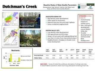
Fecal Coliform Levels Exceeding Texas Regulatory Criteria in 1989 using ASSESS
Soil Coverage (convert to grid) Needed to add From LBJ Area Cataloging Unit
BASINS Models SWAT HSPF QUAL2E PLOAD
SWAT (Soil Water Assessment Tool) • Physically based model developed to predict the impact of land management practices on water, sediment, and agricultural chemical yields on complex watersheds • Considers varying soils, land use, and management conditions • Assimilates point source contributions • Performs flow and water quality routing in stream reaches
HSPF (Hydrological Simulation Program Fortran) ver 1.2 • watershed model that simulates nonpoint source runoff and pollutant loadings for a watershed • combines these with point source contributions • performs flow and water quality routing in reaches.
Permit Compliance System ONLY FOR PENNSYLVANIA
Event Mean Concentrations (EMCs) Source: Nonpoint Source Pollution in the Mission Basin GIS in Water Resources exercise
Impervious Factor Source: PLOAD Users Manual
GenScn (selecting multiple records of 31625- Fecal Coliform)
Conclusion • Basins 3.0 is still in development phase and has programming glitches • The HSPF and SWAT model learning curve is very time consuming • Help tools are useful for BASINS, but SWAT and HSPF lack good users manual