Download
1 / 13
130 likes | 280 Views
Northeast Connecticut Council of Government GIS Program. NECCOG GIS SERVICES TO ITS MEMBER TOWNS AND CLOUD BASED INFRASTRUCTURE. Eric Dorsey GIS Program Director. Rhode Island GIS User Group and Municipal User Group Meeting February 20 th , 2013 – Cranston, Rhode Island. NECCOG.

E N D
Northeast Connecticut Council of Government GIS Program NECCOG GIS SERVICES TO ITS MEMBER TOWNS AND CLOUD BASED INFRASTRUCTURE Eric Dorsey GIS Program Director Rhode Island GIS User Group and Municipal User Group Meeting February 20th, 2013 – Cranston, Rhode Island
NECCOG • Founded in 1987 • Regional Planning Organization – Council of Government • 12 member towns • NECTD – Northeastern Connecticut Transit District • Provides Numerous Services to Our Municipalities • GIS • Engineering • Animal Control • Assistance in Town Planning • POCD, Zoning, Land Use, Transportation
GIS Program • Providing Services for 10+ years • General Map Based Projects for Member Towns • Provide Published Maps for NECCOG Programs and Documents • General Mapping Assistance/Troubleshooting • NECCOG Programs • Towns and Citizens • Membership • 11 of 12 towns actively have used our services • Parcel Data has been the most active product • Currently an Hourly Rate at $45/hour for services for member towns • Assessors and Conservation Commissions our most active customers
Recent Projects • State of Connecticut POCD 2013 Updates • Digitizing Regionalized/Town Maps • Zoning • ECEC – Eastern Connecticut Enterprise Corridor • Flood Maps • HAZUS – ArcGIS extension • Most Accurate Flood Maps available to region • Trail and Historical Site Maps • Town of Pomfret • Northeast District Department of Health • Scanning Private Well and Sewer Documents linked to GIS Viewer Applications • GIS Layer indicating point and polygon placement of wells and sewers on properties 2013 POCD for Ashford HAZUS Flood Maps for Woodstock Town of Pomfret Trails Map
Parcel Data Management • CADASTRAL • Digitizing of Parcel Boundaries • Linking Assessor Data (CAMA) to Parcel • CAMA – Computer Aided Mass Appraisal Software • VISION and CLT Software • Powered by Oracle (ODB) • Annual Maintenance • Adjust lot changes • Subdivision • Merge’s • Boundary Survey’s • Publish • Assessor Maps • Regional Parcel Viewer Application ArcGIS Desktop 10.1 for Assessor Map Updates
Cloud Computing • Hosted by Amazon Web Services • Virtual Servers • Numerous Services to Choose From • NECCOG Uses 3 components • S3 – Simple Storage Service • Elastic Online Storage System • Web Enabled • Potentially a Data Backup • EC2 • Rent Virtual Computers to Run Applications • Elastic Compute Capacity • IAM • Security Management • Provide Access Keys to allow other Users to access Storage and Cloud Computers AWS Console
Data Management Flows • Assessors Office • Vision or CLT Software for CAMA • ODB format • Convert to Access Database (mdb) • Create a link to external data in Microsoft Access • Data Transfer – Traditional Approach • Flash Drive to Town Office • Bring back information to office to save on hard-drive • Modern Approach – Cloud Incentive • Automatic Transfer Approach • XML programming – executable file • Batch File • Automatically opens Access file – has macros set up to grab .odb tables and save and quit • Automatically runs the executable file to upload .mdb into proper S3 storage folder • Potentially set up a Task Scheduler to Run overnight
Data Management Flows • Simple Storage Service (S3) • Folders are referred to as Buckets • Each Town has two buckets • -CAMA Transfer • -House Photo’s (JPEG’s) • NECCOG has separate Buckets • -Town Clerk – Survey Documents • -File Transfer Buckets • Directories consistent with Cadastral setup for Map-Block-Lot • Dataserver • Has executable codes to download CAMA data from S3 into storage space on local hard drive • - Codes to upload into NECCOG buckets • ArcSDE creates a master regional database • 1) Supported by SQL Server • 2) Appends CAMA data from all towns into a regional database • 3) Links modified Cadastral Data to CAMA • 4) Enables Versioning for Multi-user Editing • 5) Convert to Cadastral Geodatabasethat is uploaded back into cloud (NECCOG bucket) • Map Documents and Other GIS Projects and Information stored as well
CADASTRAL • Federal and Statewide Standards for Data Quality and Consistency • Follow with respect to Connecticut Geospatial Information Systems Council guidelines • 3-Year Regional Incentive Grant • Scan in Town Clerk Documents of Parcel Boundary Surveys and House Photos for properties in Region • Digitize over 35,000 Parcels in our Region from Town Halls into GIS Cadastral Database • ArcGIS Desktop • Identify Parcel Locations using Survey Points and Monuments • Town Boundaries • State Boundaries • Parcel Boundaries • Run Traverses of Parcels using COGO extension in ArcToolbox • Geodatabase Topology Rules to avoid voids between property lines • Model Builder Toolsets created to Assist in Data Conversion Processes between ArcSDE and FGDB formats as well as merging of municipal data • GIS ID • The Parcel is the basic unit • Links Cadastral to CAMA • All other parcel related data can be created in respect to parcels and linked using the GIS ID • Zoning • Open Space • Address Points, etc.
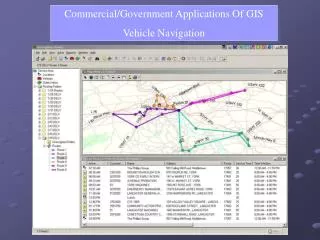
Final Product • Assessor Maps • Depending on Number of Updates • Fresh Set of Maps – Customizable to their liking in size and color scheme • Regional Parcel Viewer • Flexviewer Application • -Free to use • Access to anyone • -Public Sector • -Private Sector • -Citizens • Hosted on EC2 as a published map document on ArcGIS Server • Multiple Widgets • -Parcel Searches • -Property Cards • -Open Space and Soil Layers • -Access to Boundary Survey Documents and House Photo • gis.neccog.org/neccog Putnam Assessor Maps Regional Parcel Viewer
Program Funding • OPM Grants mainly fund the GIS Program • AWS Cloud Expenses • Software Licensing and Printing Materials • Payroll • Revenue • Can tap into other grants for specific projects • Transit • Homeland Security • HUD • Town Members • Currently on a labor fee only by the hour • Future Plans to Designate as Full or Part Time members • Full Time Members pay annual fee based on per capita • Unlimited usage of GIS services for small and medium sized projects • Costs (Uncertain) • Part Time members pay by the hour • Non Member Towns pay higher rate by the hour
Contact Information • Visit NECCOG website • neccog.org • Visit NECCOG GIS website • gis.neccog.org • Contact Information Eric Dorsey GIS Program Director Northeastern Connecticut Council of Governments 125 Putnam Pike, Dayville, CT 06241 860-774-1253 (Ext 22) eric.dorsey@neccog.org Questions or Comments? NECCOG Website Homepage