Commercial/Government Applications Of GIS Vehicle Navigation
350 likes | 532 Views
Commercial/Government Applications Of GIS Vehicle Navigation. What Is Navigation?. Reliably finding where you are, where you are going, and what route to take. Progression Of Development Early Mariners Followed Coastlines Compass and Sextant (Latitude) Shipboard Chronometer (Longitude)

Commercial/Government Applications Of GIS Vehicle Navigation
E N D
Presentation Transcript
Commercial/Government Applications Of GIS Vehicle Navigation
What Is Navigation? Reliably finding where you are, where you are going, and what route to take. • Progression Of Development • Early Mariners Followed Coastlines • Compass and Sextant (Latitude) • Shipboard Chronometer (Longitude) • Radio Based Navigation • GPS
The Primary Goal Of Employing A GIS To Perform Vehicle Navigation: To Maximize Efficiency
Business And Commercial Vehicle Navigation Using GIS • Objectives / Goals: • Maximize Efficiency • Minimize Costs • Improve Quality of Service • Manage Resources
Business And Commercial Vehicle Navigation Using GIS • Role Of GIS • Route Planning • Geocoding • Spatial Analysis / Querying • Statistics • Visualization
Business And Commercial Vehicle Navigation Using GIS • Data Model • Primarily Vector Model (Network Framework) • Some Raster Data Incorporation (Background) • Data Required (all georeferenced) • Road Networks • -Distances • -Speed Limits • -Constraints (One-way, weight limits, etc.) • Buildings • Businesses • Contact / Customer Locations • Imagery For Orientation Assistance
Business And Commercial Vehicle Navigation Using GIS • Data Available (examples) • Many Commercial Sources • - NavTech • - Tele Atlas • Federal, State, and Municipal Government • - Roads • - Elevation (DEMs or Contours) • - Digital Orthophotos • In-House Data Collection • - Collection Crews • - Driver Sensor Logs
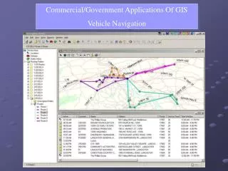
Business And Commercial Vehicle Navigation Using GIS • GIS Operations • Data / Order Entry • -Geocoded Destinations • Route Planning / Network Analysis • -Shortest Distance • -Fastest • -Optimal Distribution of Resources • Queries • -Who Is Nearest To This Location? • -Travel Time To Destination?
Business And Commercial Vehicle Navigation Using GIS • User Interaction • Office Only • In-Vehicle (Real-Time Updates)
Business And Commercial Vehicle Navigation Using GIS Office Only • User Interactions / Outputs • Route Planning • Order Entry • Address Verification / Correction • Driver Manifest Creation • Route Map / Directions • Customer Service (time window estimates)
Business And Commercial Vehicle Navigation Using GIS In-Vehicle • Use Of Static Maps • OR • Real-Time Route Modifications Due To: • Weather Conditions • Traffic Conditions • Road Maintenance / Closures • Mechanical Difficulties • New Orders • On Schedule / Late / Ahead Of Schedule • Customer Scheduling Conflicts • Driver Preferences
Business And Commercial Vehicle Navigation Using GIS In-Vehicle • Other Operations / Outputs: • Database Correction • Map Updates • Queries (ex: what clients are within a distance?) • Order Modification / Rescheduling • Directions To Locations (Could Be Verbal) In-Vehicle Navigation GIS utilizes inputs from onboard sensors/equipment such as GPS receivers and radio communication equipment to provide real-time updates of data and route changes.
Business And Commercial Vehicle Navigation Using GIS Examples Of Potential / Current Types Of Businesses Utilizing GIS For Navigation: • Traveling Sales / Sales Representatives • Appliance Delivery (Sears) • Repair / Service • Cable TV Installers • Pizza Delivery • Taxi Companies (Oslo Taxi, Norway) • Freight Shipping • Package Delivery (UPS & FedEx)
Government Agency Vehicle Navigation Using GIS • Objectives / Goals: • Maximize Efficiency • Interact With Other Agencies • Effective Emergency Response • Manage Resources • Safety Of Citizens And Troops
Government Agency Vehicle Navigation Using GIS • Role Of GIS • Route Planning • Infrastructure Information • Spatial Analysis / Querying • Analyze Movement Of Resources • Visualization
Government Agency Vehicle Navigation Using GIS • Data Model • Both Vector and Raster Model Dependent Upon Application • Data Required (all georeferenced) • Road Networks • Railway Networks • Hydrography (Streams & Rivers, Lakes) • Municipal Emergency Response Facility Locations • Buildings • Government Installations (Military Bases, Facilities) • Imagery For Orientation Assistance • Elevation (DTMs, Contours, TINs, etc.) • Land Cover (from remote sensing imagery)
Government Agency Vehicle Navigation Using GIS • Data Available (examples) • Many Commercial Sources • - NavTech • - Tele Atlas • Federal, State, and Municipal Government • - Roads • - Land Cover • - Hydrography • - Elevation (DEMs or Contours) • - Digital Orthophotos • - Satellite Imagery
Government Agency Vehicle Navigation Using GIS • GIS Operations • Data Entry / Updating • Route Planning / Network Analysis • -Shortest Distance • -Fastest • -Safest Route • -Passable Route • -Most Strategic • -Optimal Distribution of Resources • Queries • -Ex: Nearby Resources • Monitoring Of Resource Locations
Government Agency Vehicle Navigation Using GIS • User Interaction / Outputs • Route Maps (Printed and Electronic) • Route Modifications Due To Changes In Conditions • Monitoring Movement Of Resources – Real-Time • Driving Directions – Audible and Visual • Queries • Secure Web-Served Information, Wireless Capable • Sensor Inputs For Real-Time Monitoring • GPS Onboard Vehicles • Digital Compass / Inclinometers / Gyroscopes • Odometer • Radio Communication Equipment
Government Agency Vehicle Navigation Using GIS Examples Of GIS Vehicle Navigation Applications In Government • Military Cargo Shipping • Ambulance Route Planning • Military Campaign Operations • Emergency Response
Modeling Reality • Model Depends Upon Type Of Operations Desired • Vector – Network Analysis • Raster – Surface Analysis Most Vehicle Navigation GIS In Business Applications Use Vector Networks To Model Reality
Modeling Reality • Vector Model – Network Analysis • Foundation Is Graph Theory • Network Of Interconnected Nodes • Based Upon Topology And Geometry • Nodes Represent Entities • Connections (Links) Represent Relations Between Entities Topology: Characteristics Of Entities That Do Not Depend Upon Measurement In A Coordinate System
Modeling Reality: An Example Network Representation Allows Analysis - Route / Path Planning A Simple And Early Example Of Graph Theory / Navigation The 7 Bridges Of Königsberg – The Euler Path
The 7 Bridges Of Königsberg – The Euler Path Bridges Modeled As Links Land Forms Modeled As Nodes (In This Example There Is No Path Where Every Bridge Is Visited Exactly Once)
Navigation Routing Algorithms Primary Goal Of Most Navigation Problems: Finding The Most Efficient Route Vector Network Model And Graph Theory Allow Analysis Of Network To Optimize Navigation Routes • A Variety Of Algorithms Exist For Route Optimization: • Dijkstra’s Shortest Path Algorithm • -Weighted Links • -Best Path Chosen By Minimizing Weights And Distances • Heuristic Methods • -Graph Growth Algorithm • Genetic Algorithm • -Path Chosen Based Upon Fitness
Examples Of Business And Government GIS Vehicle Navigation Applications In Use • Business Example: • Sears, Roebuck, and Co. • Government Agency Example: • IRRIS
A Business Example: Sears, Roebuck & Co. • Reasons For Implementing A GIS • For Route Navigation • More Efficient Vehicle Use • Reduce Delivery Window • Optimize Delivery Routes • Improve Customer Service • Increase Customer Satisfaction The Result: The EHDS, Implemented in 1997 EHDS Is An Acronym For: Enhanced Home Delivery System
Sears’ EHDS • The Problems: • Over 4 Million Appliance Deliveries Per Year • Manual Tasks Occupied Large Amounts Of Employee Time • Delivery Windows Of Around 6 Hours • Delivery Windows Missed At Least 20% Of The Time • Inefficient Fleet Management • Errors In Address Information
Sears’ EHDS • Goal: • To Reduce The Delivery Window To Two Hours • And Be Within That Window At Least 90% Of The Time • Implementation: • Customized Version Of ESRI’s ArcLogistics Package • Vector Data Model
Sears’ EHDS • Inputs / Interaction: • Orders Placed, Delivery Date Scheduled • Geocoding Verifies Addresses • Correction Of Incorrect Address Information • Voice Response Unit Tracks Progress Of Each Driver • Drivers Can Report Conditions – Routes Recomputed • GPS Vehicle Tracking • Outputs / Visualization • Driver Manifests • -Address, Item, Delivery Window, Directions • Real-Time Fleet Monitoring On Maps In Office
Sears’ EHDS • The Results: • Address Verification Reduced From Five Hours Daily To A Maximum Of 20 Minutes. • Miles Per Stop Reduced By 0.6 Mile While Adding 4 More Stops Per Truck • Consolidation Of Routing Centers From 46 To 12 • A 9.2 Percent Increase In Delivery Orders With Same Fleet Size • Annual Savings Of At Least $30 Million • Ontime Performance Increase From 78% To More Than 90% • Customer Satisfaction Rate Increase From 84.7% To 87.4% • Drive Time Reduced By 6% • Overtime Pay Reduced By 15%
Government Example: IRRIS Military Cargo Transportation Routing, Navigation, And Monitoring • Tasks Performed: • Aggregation Of Transportation Information • Assistance With Logistical Decision Making • Access To Data By 400-500 Military Users • Dynamic Adaptation Due To Conditions • Providing Navigation Directions • Identification Of Best Route For Transit • Secure Data Delivery To Users (Drivers Included) • Tracking Freight And Personnel Shipments
Government Example: IRRIS • Who Is Responsible? • Primary Development Contractor: Intergraph • Agency: MTMCTEA • (Military Traffic Management Command Transportation Engineering Agency) • Data Incorporated: • 104+ Different Data Layers, From Commercial Sources As Well As Govt. • About 1 Terabyte Of Data • Vector Data Model Primarily, But Some Raster Data Utilized • Intelliwhere Location Server • Base Maps From NavTech
Government Example: IRRIS • User Interactions: • Real Time Monitoring Of Locations Of Military Shipments • Interactive Point-Click Interface • Weather And Road Conditions Updated Real-Time • Route Planning Based On: • -Cargo Type / Weight / Size • -Truck Type • -Route Conditions • -Security Concerns • Web Based Secure Server Provides Bidirectional Live Updates • Driver Directions • -Aerial Photos Available Online For Route Clarification • -Hazardous Materials Roads • -Railways, Waterways, Terminals
Government Example: IRRIS IRRIS Is still evolving. The goal is for IRRIS to become a one-stop shop on the web for transportation infrastructure information. Static transportation information is combined with live vehicle tracking and route condition data. Although originally designed for military applications, businesses and private citizens are finding new uses for IRRIS as well. Source: Geospatial Solutions, February 2003, “Fort To Port”, Barthello and Beiagi, Pp. 28-31