Download
1 / 58
580 likes | 782 Views
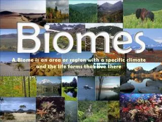
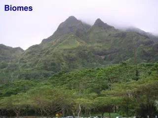
Biomes. Weather - particular set of physical properties of the Earth’s troposphere: Temperature, pressure, humidity, precipitation, sunshine, cloud cover, wind direction and speed

E N D
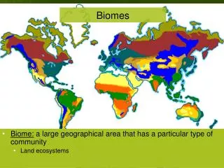
Weather - particular set of physical properties of the Earth’s troposphere: • Temperature, pressure, humidity, precipitation, sunshine, cloud cover, wind direction and speed • Climate – a region’s general pattern of atmospheric or weather conditions, including seasonal variations and weather extremes over a long period. • Biome – a large geographical region having a defining climate to which plants show a similar physiological adaptation.
Four Global Temperature Regimes Hot • Tropical • Temperate • Subpolar • Polar Cold
Four Plant Types • Succulent – vertical orientation on most parts, no leaves, store water, photosynthesis in tissue • Cactus • Broadleaf Evergreen – keep most of their broad leaves year-round • Tropical trees • Broadleaf Deciduous – drop their leaves when it gets cold (dry in the tropics) • Oak, maple, pecan • Coniferous (cone-bearing) Evergreen Plants – keep their narrow pointed leaves (needles) all year • Pine, spruce, fir
General Biome Types • Forest – dominated by trees • A lot of precipitation needed • Scrubland – small deciduous trees and shrubs • Some precipitation needed • Grassland – dominated by grasses • Does not need as much precipitation as a forest • Usually needs disturbance to limit tree growth • Grazing, fire • Desert – dominated by succulents • Very little precipitation ‘For plants, precipitation generally is the limiting factor that determines whether a land area is desert, grassland, or forest.’
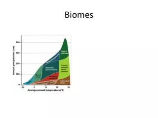
Temperature and precipitation regulate plant growth, thus the regional distribution of biomes. Boundary lines between biomes are not as distinct as implied here.
Tropical, Temperate, or polar – Depends on Temperature Forest, Grassland, or Desert – Depends on Rainfall
Cell 3 North Cold, dry air falls Moist air rises — rain Polar cap Cell 2 North Arctic tundra Evergreen coniferous forest Cool, dry air falls 60° Temperate deciduous forest and grassland Cell 1 North Desert 30° Moist air rises, cools, and releases moisture as rain Tropical deciduous forest Tropical rain forest 0° Equator Tropical deciduous forest 30° Desert Cell 1 South Temperate deciduous forest and grassland Cool, dry air falls 60° Cell 2 South Polar cap Cold, dry air falls Moist air rises — rain Cell 3 South Global air circulation affects local precipitation A combination of insolation and precipitation determines global biome distribution
Rivers and Streams • Generally represent the excess of precipitation on land areas over evaporation from them. • Precipitation that falls is either evaporated, transpirated, enters the ground water supply, or flows down rivers • Flow is down-hill and varies seasonally • Related to rainfall and ice/snow melt • Beginning of a river = the source and the end of a river = the mouth • Discharge - volume of water passing a given point during a period of time • Channel Width X Depth X Velocity
Rivers and Streams • Flow velocity is important in determining abiotic and biotic components. • Flow related to slope and precipitation • Sediment type, current strength • The faster the flow, the more material can be transported in the water • Only certain organisms can withstand strong flow • Materials are transported by running water in three principal states • Dissolved matter • Suspended solids • Bed load
1 1 1 1 2 2 1 2 3 Stream Order – Strahler Method Stream Order Used to classify a stream in relation to tributaries, drainage area, total length, and age of water. 1 1 = 2 1 2 = 2 2 2 = 3 1 3 = 3 2 3 = 3 3 3 = 4 Mississippi River is classified as a 10th or 12th order stream. Headwater stream classification matters
You will be required to draw a map of the major rivers of the Mississippi River Basin as part of exam 1.
Flow Mississippi River (Main Stem) Atchafalaya River (Distributary) Distributary – A smaller channel that takes water away from the main stem river.
Construction of levees along the Mississippi River and many of its tributaries has severed the river from over 90% of its floodplain, denying fish and other aquatic species access to millions of acres of foraging, spawning and nursery habitat. Miss. Dept. of Archives and History Miss. Dept. of Archives and History http://www.lmrcc.org/ARMP%20folio.pdf
Estuaries Swamps and marshes Tropical rain forest Temperate forest Northern coniferous forest (taiga) Savanna Agricultural land Woodland and shrubland Temperate grassland Lakes and streams Continental shelf Open ocean Tundra (arctic and alpine) Desert scrub Extreme desert 800 1,600 2,400 3,200 4,000 4,800 5,600 6,400 7,200 8,000 8,800 9,600 Average net primary productivity (kcal/m2/yr) Net Primary Production (measure of available energy)
Where Are We? Ponchartrain Atchafalaya N Barataria Terrebonne
Terrestrial Vegetation Growth During Low Water Nutrients Released During High Water
= Happy Cajuns!! Simply put: More Nutrients = More Plants = More Animals Inundation of the floodplain is the mechanism of energy and nutrient transfer from terrestrial vegetation to the aquatic community.
The Floodplain Extends to the Coast • All flowing Louisiana waterways eventually drain to the Gulf of Mexico • Energy and nutrients from floodplain terrestrial vegetation are carried to coastal waters and sustain estuarine and coastal production • The coast is ultimately supported by floodplain ecosystem processes
Barataria-Terrebonne National Estuary Baton Rouge New Orleans Thibodaux Houma Port Sulphur Grand Isle
Three General Types of Water • Brown • High flow, lots of sediment, fairly high oxygen levels, riverine • Green • Low flow, stratification, very high surface oxygen levels, highly productive, lacustrine • Black • Low flow, very low surface oxygen levels, not productive, swamp
Backwater Interior Lakes Mainstem December June August
Oxygen Level Controls Photosynthesis produces oxygen: Solar Energy + CO2 + H20 C6H12O6 + O2 Respiration consumes oxygen: C6H12O6 + O2 CO2 + H20 + chemical energy(ATP)
What is Hypoxia • Dissolved Oxygen (DO) less than 2.0 mg/L • Normoxic = DO > 2.0 mg/L • Generally, most fish can not tolerate hypoxic conditions for long periods. • Gar, bowfin (choupique), bullheads can
Why Hypoxia? • During low water times, the dry lands are extremely fertile and grow a lot of plants. • When the spring floods come and temperatures rise, bacteria begin to decompose the vegetation on the floodplain floor. • Bacterial respiration is what removes the oxygen (lack of flushing in backwater habitats contributes). • Respiration rates exceed photosynthetic rates.
When and Where Is Hypoxia? • Generally found during high water times when temperatures are warm. • Backwater areas (away from the mainstem river). • Low flow
Eventually the swamp drains and backwater areas become very productive.
How Do ‘Unproductive’ Areas Support Living Populations? • Submerged Aquatic Vegetation • Oxygen Refuge • Productive microhabitats
Fish and Aquatic Vegetation • Densities of young fish are often greater in aquatic vegetation than in adjacent open water
Normoxic Hypoxic Mean Surface Dissolved Oxygen in Open Water and Plants at Each Site Green Brown Black
Air-Water Interface Atmospheric oxygen diffuses into water Fish ‘pipe’ at the microsurface layer Low DO Water
How Do ‘Unproductive’ Areas Support Living Populations? • Detritus-Based Production • Decomposers (e.g., bacteria) transfer energy stored in old organic matter to consumers • Insects, crawfish • Low-oxygen tolerant organisms • Gar, bowfin (choupique), bullheads
Energy flow through an aquatic ecosystem. From Cole 1988, Waveland Press
Terrestrial leaf litter/detritus input during Flood Pulse Detritus Based Food Web. From Cole 1988, Waveland Press
Major Ocean Currents Effect on Climate • Insolation (and associated effects), the Earth’s rotation, plus difference in water density, create warm and cool currents.
Oceans • Coastal regions are much more productive than non-coastal areas. • Rich nutrient input from coastal rivers • Most of the worlds great fisheries come from the continental shelf • Too many nutrients can lead to algal blooms, which may deoxygenate the water (eutrophication)
Oceans • Salinity averages 35 ppt (full strength sea water). • Due to high concentrations of sodium and chloride • Ocean is more than salt and water, but most ocean waters are very poor in nutrients • Phosphate, nitrate, ammonium, iron • Oceans cover ~71% of Earth, but only account for 50% of the Earth’s primary production. • Biological deserts not limited by water, but by nutrients • Unlike terrestrial biomes, production is not higher at equator and lower at the tropics –respond to nutrient concentrations like upwellings.
Upwelling Productivity Global estimates of the primary production required to sustain fisheries in five marine ecosystems. Production is highest in shallow well-lit coastal waters and upwellings.