Download
1 / 16
160 likes | 328 Views
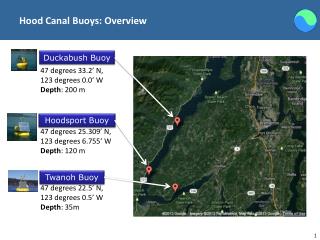
Hood Canal Buoys: Overview. Duckabush Buoy. 47 degrees 33.2’ N, 123 degrees 0.0’ W Depth : 200 m. Hoodsport Buoy. 47 degrees 25.309’ N, 123 degrees 6.755’ W Depth : 120 m. Twanoh Buoy. 47 degrees 22.5’ N, 123 degrees 0.5’ W Depth : 35m. Hood Canal Buoys: Distances Apart.

E N D
Hood Canal Buoys: Overview Duckabush Buoy 47 degrees 33.2’ N, 123 degrees 0.0’ W Depth: 200 m Hoodsport Buoy 47 degrees 25.309’ N, 123 degrees 6.755’ W Depth: 120 m Twanoh Buoy 47 degrees 22.5’ N, 123 degrees 0.5’ W Depth: 35m
Hood Canal Buoys: Distances Apart Duckabush Buoy 47 degrees 33.2’ N, 123 degrees 0.0’ W Depth: 200 m Hoodsport Buoy 47 degrees 25.309’ N, 123 degrees 6.755’ W Depth: 120 m 17 km Twanoh Buoy 47 degrees 22.5’ N, 123 degrees 0.5’ W Depth: 35m 8 km 7 km
Ocean-TUNE Deployment: Candidate Location Hoodsport Buoy Glen Ayr Resort Hoodsport Hatchery Union Marina Potlatch Marina
Ocean-TUNE Deployment: Candidate Location Hoodsport Buoy 1.3 km Glen Ayr Resort 3.0 km 7.0 km 7.2 km Hoodsport Hatchery Union Marina Potlatch Marina
Ocean-TUNE Deployment: Candidate Location Hoodsport Buoy 1.3 km Glen Ayr Resort 2.0 km 3.0 km glenayr@hctc.com Hoodsport Hatchery Port of Hoodsport portmail@hctc.com
Available Environmental Data • PSBathy.mat: • longgrid • latgrid • z • lonshore • latshore • HCBathy.mat: • longgrid • latgrid • z • lonshore • latshore • Buoy CTD Data: • Ztime: Yearday from 2000 (yearday 1 = January 1, 2000) • Zpress: Pressure, db • Zcond: Conductivity, S/m • Ztemp: Temperature, degrees C • Zsal: Salinity, psu • Zsigma: Sigma-T, kg/m • Zv0: voltage of channel 1 • Zv1: voltage of channel 2 • Zv2: voltage of channel 3 • Zv3: voltage of channel 4 • ZoxyVolt: voltage of oxygen channel • Zoxy_mgL: Oxygen, mg/L • Zoxy_umol: Oxygen, umol/kg • Zoxysat_mgL: Oxygen saturation, mg/L • Zoxysat_umol: Oxygen saturation, umol/kg • Zoxypersat: Oxygen percent saturation, percent • Zfluor: Fluorometer, mg/m^3 • Znitrate: NO3, umol • Zpar: PAR, uEinsteins/m^2-sec
Hood Canal Buoys Duckabush Buoy 47 degrees 33.2’ N, 123 degrees 0.0’ W Depth: 200 m Hoodsport Buoy 47 degrees 25.309’ N, 123 degrees 6.755’ W Depth: 120 m Twanoh Buoy 47 degrees 22.5’ N, 123 degrees 0.5’ W Depth: 35m
Hood Canal Buoy Information Physical Dimensions Modem Attachments / Communication Systems Power Supply Regular Operations Mode
Twanoh Buoy: Power Supply • Two 24V battery packs • Solar panels • Wind turbine
Communication System • Communication System: WiFi • Twanoh: onboard WiFi amplifier and router • Hoodsport: only WiFi amplifier, access point at nearby library
Operations Mode • Sample the water as much as 12 times a day and as few as 3 times a day • Sampling takes approximately 20 minutes • Power drain to be determined • Sampling hardware package includes sensors to measure CTD data (conductivity, temperature, and depth)