Download
1 / 57
570 likes | 684 Views
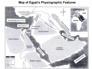
http://pubs.usgs.gov/publications/text/East_Africa.html. http://www.utexas.edu/depts/grg/hudson/grg301c/hudson_grg_301c/schedule/3_rocks_earth_images/6_tectonics/11.htm. Antietam Sandstone – base of Blue Ridge, Luray, Virginia. Modern Stromatilites from Shark Bay, Western Australia.

E N D
http://www.utexas.edu/depts/grg/hudson/grg301c/hudson_grg_301c/schedule/3_rocks_earth_images/6_tectonics/11.htmhttp://www.utexas.edu/depts/grg/hudson/grg301c/hudson_grg_301c/schedule/3_rocks_earth_images/6_tectonics/11.htm
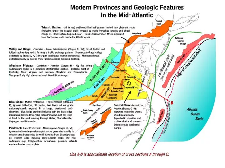
Edinburg Limestone – Page Valley east of Luray: deep water black limestones
Martinsburg – Page Valley east of Luray: turbidity sandstones and shales
Top: cross section interpreting the environments represented in the Greenbrier formations. Bottom four pictures images from the Bahamas, modern analogues to environments in the Greenbrier Embayment. Middle left: satellite photo taken from the space shuttle of a portion of the Bahama island chain south east of Florida. The whitish areas are areas of shallow carbonate formation and deposition, while the darker blue areas are deeper water. Middle left: shore line view in the Bahamas. Bottom left and right: airplane images from the Exuma cays in the Bahamas. White areas under water are carbonate sediments moving about by the currents. Bottom left illustrates areas of strong, scouring currents (darker blue) and small bays where carbonate sands accumulate. Bottom right shows rippled carbonate sands. The oolites in the Greenbrier were deposited under analogous conditions.
Delta progrades (builds out) into the shallow inland sea depositing a thick wedge of sandstone while converting marine environments into terrestrial environments. Deltas prograde for only a few hundred years before they are abandoned. Then they sink and the sea washes across, burying them under a marsh, and then marine sediments. A marsh (coal swamp) develops as the sea transgresses across the abandoned delta lobe, while a barrier island forms off the coast. Continued sinking allows a thick peat layer to form, and when the next delta lobe moves into the area the peat is buried, compressed, and turned into coal.
http://www.life.uiuc.edu/plantbio/PlantBioWeb/NewsPages/NewsPhillips.htmlhttp://www.life.uiuc.edu/plantbio/PlantBioWeb/NewsPages/NewsPhillips.html
http://www.kgs.ukans.edu/Publications/Bulletins/227/gifs/coal_swamp.gifhttp://www.kgs.ukans.edu/Publications/Bulletins/227/gifs/coal_swamp.gif http://www.ucmp.berkeley.edu/carboniferous/carboniferous.html
http://www.healeyhero.info/rescue/pictures/reminise/forest.jpghttp://www.healeyhero.info/rescue/pictures/reminise/forest.jpg
Richmond Basin cross section following complete subsidence.. Although the history is complex, it begins with a wet climate and coal deposits such as the 36 foot thick Black Heath coal bed. In the middle history the climate is semi-arid and the area looks more like Nevada - desert-like with dry river washes and scrub vegetation - than Virginia. By the end it has been estimated that the entire piedmont is buried under thousands of feet of sediment.
Reconstruction of Waterfall Lake, Culpepper basin, low-water stage. There is a high fault block mountain on the western edge, feeding alluvial fans on the west side of the lake. The eastern broad, flat area is an exposed alluvial plain with rivers draining across it. Small density (turbidity) currents carry sediment toward the lake bottom. At this stage the lake is shallow, oxic, and accumulating red sediments; higher water levels cover the alluvial plain and lead to oxygen poor bottom waters. Early dinosaurs roam across the area, the first tiny mammals scurry in the undergrowth, and fish and aquatic reptiles swim in the lakes. Redrawn from Hentz, 1985.
Virginia during the Triassic rifting was in many ways similar to the Basin and Range Province of Nevada today. Horst and block mountains and a semi-arid climate with very little vegetation and salt flats in the valleys. http://waynesword.palomar.edu/images/playa.gif