Download
1 / 35
350 likes | 518 Views
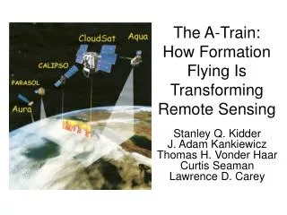
The A-Train: How Formation Flying Is Transforming Remote Sensing. Stanley Q. Kidder J. Adam Kankiewicz Thomas H. Vonder Haar Curtis Seaman Lawrence D. Carey. CloudSat. CALIPSO. Aqua. PARASOL. Aura. The A-Train.

E N D
The A-Train: How Formation Flying Is Transforming Remote Sensing Stanley Q. KidderJ. Adam Kankiewicz Thomas H. Vonder Haar Curtis SeamanLawrence D. Carey
CloudSat CALIPSO Aqua PARASOL Aura The A-Train • The Afternoon Train is lead by Aqua, with an ascending equator crossing time of 1:30 pm
Aqua • An observatory-class satellite with six instruments: • Moderate Resolution Imaging Spectroradiometer (MODIS), • Atmospheric Infrared Sounder (AIRS), • Advanced Microwave Scanning Radiometer for EOS (AMSR-E) • Advanced Microwave Sounding Unit (AMSU-A) • Humidity Sounder for Brazil (HSB) • Clouds and the Earth's Radiant Energy System (CERES) • Yet there is so much more to do….
CloudSat and CALIPSO • CloudSat carries the • 94 GHz Cloud Profiling Radar (CPR) • CALIPSO carries • 532 and 1064 nm Cloud-Aerosol Lidar with Orthogonal Polarization (CALIOP) • Imaging Infrared Radiometer (IIR) • Wide Field Camera (WFC)
PARASOLand Aura • PARASOL carries • POLDER (Polarization and Directionality of the Earth’s Reflectances) • Aura carries • High Resolution Dynamics Limb Sounder (HIRDLS) • Microwave Limb Sounder (MLS) • Ozone Monitoring Instrument (OMI) • Tropospheric Emission Spectrometer (TES)
73 seconds 131 seconds 900 seconds Formation Flying:Control Boxes CloudSat is maintained 12.5 ± 2.5 seconds ahead of CALIPSO Aura is maintained ~15 minutes behind Aqua PARASOL is maintained in a control box of ±21.5 seconds CALIPSO is maintained in a control box of ±21.5 seconds Aqua is maintained in a control box of ±21.5 seconds 15 sec 30 sec
Formation Flying:Horizontal Separation Aqua CloudSat 40°N PARASOL CALIPSO 20°N Equator Aura 20°S 40°S 60°W 30°W 0°
Formation Flying:Horizontal Separation NIGHT To avoid sun glint, CALIPSO and CloudSat are offset 215 km in the anti-solar direction (maximum 240 km) from Aqua’s ground track at the ascending node. Descending Node CloudSat & CALIPSO Aqua Ascending Node 215 km DAY
Requirement on simultaneity of radar and lidar measurements: Measurements of the same cloud fields taken 15 seconds Requirement/goal on spatial overlap of radar and lidar measurements: Footprints must pass 2000 meters edge to edge Equivalent to controlling CloudSat's groundtrack to being within ±1 km of CALIPSO's lidar track Goal for footprints to overlap at least 50% of the time Science Requirements Relatedto Formation Flying with CALIPSO Position of footprints relative to groundtrack Lidar footprint (Dia= 70m) 15 seconds (113 km) 2000 m Time delayed Lidar footprint Radar footprint (Dia= 1400m) Goal condition met CloudSat Groundtrack
Cloud Layer Experiments (CLEX)Ten experiments since 1995 Generating Cells ~ 1-1.5 km in Length Optically Opaque Mixed-Phase Region (~300-500 m deep) Precipitating Ice Region (~.2-2.5 km deep) What we have learned: Supercooled Liquid = = Ice Typical Particle Concentrations: 100-200 cm-3 (Liquid) 20-150 L-1 (Ice)
o Temperature ( C) -3 (g m ) Water Content Typical Mixed-Phase Cloud Structure Liquid Water on Top 5 -20 LWC -15 IWC Height (km) 4 -10 3 Ice Below -5 0.00 0.05 0.10 0.15 0.20 0.25 The vertical profile of LWC (red diamonds) and IWC (blue diamonds) during the 14 October 2001 straight-line ascent from 1440 to 1510 UTC.
Mixed-Phase Clouds Viewed By MODIS/CloudSat/CALIPSO −178 −176 −174 −172 −170 −168 −166 A −22 −24 −26 −28 7/21/06 22:55 UTC MODIS 11 µm B
Mixed-Phase Clouds Viewed By MODIS/CloudSat/CALIPSO A VIIRS Cloud Phase Algorithm B
10 10 5 5 Height (km) Height (km) 0 0 CloudSat Radar Reflectivity (dBZ) CloudSat & CALIPSO Data B A CloudSat Radar Reflectivity (dBZ) -40 -30 -20 -10 0 CALIPSO 532 nm Backscatter
10 -35 TB11 (°C) 5 Height (km) 25 0 VIIRS Cloud Phase Algorithm (top of image) MODIS TB11 A B GEOPROF-Lidar Cloud Layers: Detected by CloudSat Detected by CALIPSO
The Future:More satellites Joining A-Train in 2008(?) are GLORY and OCO
The A-Train was not the first Train: • EO-1 flew 1 min behind Landsat 7 • SAC-C flew 27 min behind EO-1 • Terra flew 2.5 min behind SAC-C The Future:More Trains
The Future:Overflyers Overflyer (~824 km) A-Train (705 km) Satellites in the same orbital plane, but at different altitudes would leverage the extensive cal/val efforts of the A-Train satellites (or satellites in other trains).
10 10 10 -35 TB11 (°C) 5 5 5 Height (km) Height (km) Height (km) 25 0 0 0 CloudSat Radar Reflectivity (dBZ) A B GEOPROF-Lidar Cloud Layers CALIPSO 532 nm Backscatter
Formations… • Their mean anomalies and arguments of perigee must be related. • Let Dt be the desired separation time. Then their angular separation must be: Assumes a circular orbit, for which M = • Their right ascensions of ascending node must be related so that they travel over the same ground track:
A-Train Orbital Parameters • Aqua ECT = 13:35:19 • A-Train satellites make 233 orbits in 16 days and fly on the WRS-2 grid
Constellations Several identical satellites in cooperative orbits • Make possible new observing capabilities • Take advantage of economies of scale • Can reduce launch costs
A Sunsynchronous Constellation • 7 satellites • Observations each 101 minutes
Abstract The A-Train, consisting currently of five satellites—Aqua, CloudSat, CALIPSO, Parasol, and Aura—constitutes the latest and most advanced example of formation flying. In this paper we will detail how the A-Train has transformed the way we study mid-level clouds, which obstruct visibility, pose an icing hazard to aircraft, and are difficult to forecast. Although they have been studied for many years using satellite and aircraft data, we still do not know how many mid-level clouds there are, what their geographical distribution is, or how they relate to cirrus clouds above and liquid water clouds below. A-Train instruments, especially MODIS, CloudSat, and CALIPSO, are yielding answers to these and other questions that are unobtainable by other means. Finally, we will discuss what we see as the role of formation flying in the future of remote sensing.
Outline • The A-Train (4 min) • Examples, including mid-level clouds (4 min) • The future (4 min)
The A-Train • CloudSat lags Aqua by a variable amount <120 s • CALIPSO lags CloudSat by 15 ± 2.5 s • CloudSat and CALIPSO fly about 220 km to the right of Aqua to avoid sun glint • PARASOL lags Aqua by ~2 min • Aura lags Aqua by ~15 min Stephens et al., 2002: The CloudSat mission: A new dimension of space-based observations of clouds and precipitation. BAMS, 83, 1771-1790.
A-Train Control Boxes • Aqua, CALIPSO, and Parasol have independent control boxes • CloudSat’s control box is slaved to CALIPSO when formation flying • Satellite positions in the A-Train and Control Box dimensions specified in the ACOCP document CALIPSO positioned 73 s behind Aqua (CALIPSO is controlled to +/-10-km at the Equator crossing measured along the equator = +/- 21.5 sec)
CloudSat, Aqua, and CALIPSO in Formation Aqua Control Box Calipso Control Box CloudSat C.B. Circulation Orbit 30 sec (225 km) Circulation Orbit Circulation Orbit orbit ≈ 15 sec (112 km) 43 sec 43 sec (322 km) 116 sec (870 km) Aqua, CloudSat, and CALIPSO in their formation configuration. Aqua leads. CALIPSO follows but maintains its motion independent of Aqua within its control box. CloudSat is tied to CALIPSO's movement around its box. CloudSat follows a small circulation orbit, 2.2 seconds (16.5 km) along-track, positioned 12.5 seconds in front of CALIPSO.
The original goal of the CloudSat formation flying architecture was to overlay the radar footprints on the lidar footprints of CALIPSO at least 50% of the time. Analysis indicates that the overlap occurrence of radar and lidar footprints >90%, exceeding the goal.