Download
1 / 42
420 likes | 552 Views
High-Rate GPS: Earthquakes, Ice Sheets, and Volcanoes. Kristine M. Larson University of Colorado. Outline. Low-Rate/High-Rate GPS Ice Sheets Earthquakes Volcanoes My Noise/Your Signal?. Plate Boundary Deformation. Global Plate Motions. ITRF2005 Altamimi et al., 2007.

E N D
High-Rate GPS: Earthquakes, Ice Sheets, and Volcanoes Kristine M. Larson University of Colorado
Outline • Low-Rate/High-Rate GPS • Ice Sheets • Earthquakes • Volcanoes • My Noise/Your Signal?
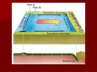
Global Plate Motions ITRF2005 Altamimi et al., 2007
Episodic Slip Rogers and Dragert, 2003
What about more geodetically challenging temporal behavior? • Ice sheet speeds, ~100 m/yr (1-2 cm/hr); are they linear? • Earthquakes, 1-30 cm/sec; large accelerations. • Volcanoes, 1-2 cm/hr; not linear, but low accelerations.
Ice sheets Photo: Roger Braithwaite
Ice sheet velocities in Greenland • Install poles; measure position. • Return following year; remeasure position; compute velocity. Thomas et al., 2000
Geodetic Challenges • 1996: power and memory restrictions. • Tracking limited to 12 hours every 10-15 days. • Constellation limitations. • How long do we need to track?
East North Vertical White noise (no smoothing) Loose random walk (smoothing) Tight random walk (more smoothing) Larson et al., Polar Geography, 2002
Ice Sheet Velocity Variations Number of days where temperature was above freezing.
Special session on Wednesday, G33B, G33C. Zwally et al., 2002.
Earthquakes • Global plate velocities are based on ~10 million measurements per site. • Each Greenland (12-hr) ice sheet velocity is based on ~1000 GPS measurements. • For seismic applications, each position is based on 6-10 measurements. Denali, November 2002
12:00 UTC 05:00 UTC N N W E W E S S Geodetic Challenges • The constellation varies. A lot.
Geodetic Challenges • Multipath (reflected signals) is important (and doesn’t difference out).
How do you choose the shift time? If GPS orbital period is 1/2 sidereal day, shift time should be 1 sidereal day (or one day minus 236 seconds).
Repeat Times: Vary by Satellite Choi et al., 2004
Vary within a Single Day Larson et al., JGR, 2007; Agnew and Larson, GPS Solutions 2007
Multipath @ Seismic Frequencies MKEA WSRT CRBT
Seismograms East Miyazaki et al., 2004; Emore et al., BSSA, 2007.
Advantages It’s an extra sensor. No clipping. Strong motion. No more double integrating acceleration. Displacement - static offsets Direct link between coseismic and postseismic. Summary: GPS Seismology
Modelled Slip meters centimeters Miyazaki et al., GRL, 2004 Miyazaki and Larson, GRL, revised
m cm cm cm cm
Volcanoes Photo: Jim Kauahikaua
55 cm extension 25 cm uplift Special session on Friday
Pu`u `O`o AHUP KTPM PGF3 Sandwell et al., submitted to IEEE GRS
Geodetic Challenges • Large signals, but over a much longer time. • But is multipath the biggest problem?
Concluding Remarks • High-rate GPS • presents many geodetic challenges… • but increases the number of geophysical applications of GPS & our impact on the AGU community. • What I have learned from high-rate GPS has improved my ability to model (and understand) errors in 24-hour averaged positions. • Multipath >> Seismology >> Multipath >> Soil Moisture.
Multipath • The frequency of ground multipath is determined by the antenna height (and we know what that is). • The amplitude of ground multipath is determined by ground reflectance, which can be related to soil moisture content.
160 210 260 day of year Soil Moisture The data are free. Kurc and Small, 2004 PBO Site Marshall, CO Larson et al., GPS Solutions, 2007
Acknowledgements • Co-authors • NSF & NASA • IGS & ITRF • UNAVCO, NEHRP, NGS, USGS, CORS, GEONET, NRCAN, SOPAC, CDDIS, IRIS, EUREF, SCIGN, GIPSY. • Fellowship from JSPS.