Download
1 / 37
370 likes | 502 Views
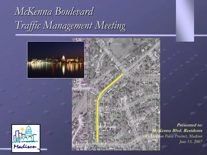
McKenna Boulevard Traffic Management Meeting. Presented to: McKenna Blvd. Residents W. Madison Police Precinct, Madison June 13, 2007. Presentation Overview. Neighborhood Traffic Management Program or NTMP Background data Types of devices used Funding Options/recommendations.

E N D
McKenna BoulevardTraffic Management Meeting Presented to: McKenna Blvd. Residents W. Madison Police Precinct, Madison June 13, 2007
Presentation Overview • Neighborhood Traffic Management Program or NTMP • Background data • Types of devices used • Funding • Options/recommendations
Why Manage Nghd Traffic? Reduce speed Shorter stopping distance Collision impact reduction Enhances Neighborhood Greener spaces Opportunity for social interaction Less noise
Street Functional Classification All Streets are classified into one of three primary classifications: 1) Arterial Streets example Verona Rd, CTH PD, CTH M 2) Collector Streets example Maple Grove, Country Grove Dr. 3) and Local Land Access Streets Gladstone, Lancaster Lane, Keighley Circle.
Street Functional Classification • Functional class is determined by: the streets arrangement within; and its connections to, the larger street system.
McKenna Blvd. Southwest Madison ArterialCollectorLocal
Neighborhood Land Uses Raymond Rd McKenna 1,850 SF 2,443 MF TTL 4,293 CTH PD 1,437 SF 1,938 MF TTL 3,375
Avg. Daily Traffic Raymond 12380 Pilgrim McKenna 7700 Putnam Lancaster Stratford Keighley 1650 Carnwood
Operational Characteristics Raymond 13050 12380 Prairie 7300 Pilgrim McKenna 6000 4700 Muirfield Putnam 10650 1650 3900 Carnwood 13450 5700 CTH PD Maple Grove Average Daily Traffic
Speed Canterbury McKenna Putnam Lancaster 31 mph 35 mph Xx mph Average Speed Xx mph 85 percentile Speed
Traffic Control Devices (Two Types) Passive traffic control devicesrely upon threat of enforcement to be effective. Active traffic control devices use physical techniques to control speed.
Priority Ranking(Point Assignment) • Average Daily Traffic Volume • ADT/100, 30 points maximum • Speed • Percent that exceed posted speed limit /3, 30 points maximum • Crash Record (police reported) • equivalent to crashes per million vehicle miles traveled or crashes per million vehicles entering intersection, 30 points maximum • Elementary and Middle Schools, 5 points
Priority Ranking • Other Pedestrian Areas, 5 points • School Walk Route, 5 points • Designated Bicycle Route, 5 points • Scheduled Road Reconstruction • project moves to top of priority ranking • A project score must equal or exceed 30 points to maintain its eligibility.
Priority Ranking McKenna Blvd Scored 61.2 points
Neighborhood Meetings Process is neighborhood driven. Consensus is gained through neighborhood involvement.
Survey If traffic diversion is not anticipated, 60% approval required of ballots RETURNED.
Construct Device Construction requires approval of Pedestrian, Bicycle, Motor Vehicle commission, Board of Public Works, and City Council. Monitor the device for effectiveness, and adjust as needed.
Possible Island Locations McKenna Canterbury Putnam Lancaster Stratford Dr Keighley Carnwood
Hard top island Landscaped island
Hard top island Landscaped island
Benefits of Island Treatment • Narrows the space available to thru traffic • Facilitates pedestrian crossings • Prevent motorists from passing on the right
Template for Traffic Island
Dis-benefits of Islands • Islands on McKenna requires: 1) Parking has to be restricted near the intersection 2) Construction cost and maintenance (landscaping is maintained by Nghd)