Download
1 / 36
400 likes | 880 Views
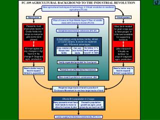
衛星遙測在變遷偵測之應用 Satellite Remote Sensing for Land-Use/Land-Cover Change Detection. 鄭 克 聲 台灣大學生物環境系統工程學系. Change Detection. Change detection is the process of identifying differences in the state of an object or phenomenon by observing it at different times.

E N D
衛星遙測在變遷偵測之應用SatelliteRemote Sensing forLand-Use/Land-CoverChange Detection 鄭 克 聲 台灣大學生物環境系統工程學系 台灣大學生物環境系統工程學系 Lab for Remote Sensing Hydrology and Spatial Modeling 遙測水文及空間模式研究室 Dept. of Bioenvironmental Systems Engineering, NTU
Change Detection • Change detection is the process of identifying differences in the state of an object or phenomenon by observing it at different times. • In general, change detection involves the application of multi-temporal datasets to quantitatively analyze the temporal effects of the phenomenon. 台灣大學生物環境系統工程學系 Lab for Remote Sensing Hydrology and Spatial Modeling 遙測水文及空間模式研究室 Dept. of Bioenvironmental Systems Engineering, NTU
Because of the advantages of repetitive data acquisition, its synoptic view, and digital format suitable for computer processing, remotely sensed data have become the major data sources for different change detection applications during the past decades. 台灣大學生物環境系統工程學系 Lab for Remote Sensing Hydrology and Spatial Modeling 遙測水文及空間模式研究室 Dept. of Bioenvironmental Systems Engineering, NTU
Applications of Remote Sensing Change Detection • Land-use/land-cover changes • Forest or vegetation change • Forest mortality, defoliation and damage assessment • Deforestation, regeneration and selective logging • Wetland change • Forest fire • Landscape change • Urban change • Environmental change • Other applications such as crop monitoring, changes in glacier mass, etc. 台灣大學生物環境系統工程學系 Lab for Remote Sensing Hydrology and Spatial Modeling 遙測水文及空間模式研究室 Dept. of Bioenvironmental Systems Engineering, NTU
Factors Affecting Accuracy ofChange Detection • precise geometric registration between multi-temporal images • calibration or normalization between multi-temporal images • availability of quality ground truth data • the complexity of landscape and environments of the study area • change detection methods or algorithms used • classification and change detection schemes • analyst’s skills and experience • knowledge and familiarity of the study area • time and cost restrictions. 台灣大學生物環境系統工程學系 Lab for Remote Sensing Hydrology and Spatial Modeling 遙測水文及空間模式研究室 Dept. of Bioenvironmental Systems Engineering, NTU
Lambin and Strahler (1994) listed five categories of causes that influenced land-cover change: • long-term natural changes in climate conditions • geomorphological and ecological processes such as soil erosion and vegetation succession • human-induced alterations of vegetation cover and landscapes such as deforestation and land degradation • inter-annual climate variability • the greenhouse effect caused by human activities. 台灣大學生物環境系統工程學系 Lab for Remote Sensing Hydrology and Spatial Modeling 遙測水文及空間模式研究室 Dept. of Bioenvironmental Systems Engineering, NTU
When selecting remote sensing data for change detection applications, it is important to use the same sensor, same radiometric and spatial resolution data with anniversary or very near anniversary acquisition dates in order to eliminate the effects of external sources such as sun angle, seasonal and phenological differences. 台灣大學生物環境系統工程學系 Lab for Remote Sensing Hydrology and Spatial Modeling 遙測水文及空間模式研究室 Dept. of Bioenvironmental Systems Engineering, NTU
Before implementing change detection analysis, the following conditions must be satisfied: • precise registration of multi-temporal images • precise radiometric and atmospheric calibration or normalization between multi-temporal images • similar phenological states between multi-temporal images • selection of the same spatial and spectral resolution images if possible. 台灣大學生物環境系統工程學系 Lab for Remote Sensing Hydrology and Spatial Modeling 遙測水文及空間模式研究室 Dept. of Bioenvironmental Systems Engineering, NTU
Major Methods of Change Detection • Post-classification methods • Image-differencing methods • Principal component analysis methods 台灣大學生物環境系統工程學系 Lab for Remote Sensing Hydrology and Spatial Modeling 遙測水文及空間模式研究室 Dept. of Bioenvironmental Systems Engineering, NTU
Statistical Perspective of Change Detection • Uncertainties involved • A statistical-test perspective • Null and alternative hypotheses • Test statistic • Level of significance 台灣大學生物環境系統工程學系 Lab for Remote Sensing Hydrology and Spatial Modeling 遙測水文及空間模式研究室 Dept. of Bioenvironmental Systems Engineering, NTU
Sources of Uncertainties inRemote Sensing Change Detection • Spatial and/or temporal variations in • atmospheric conditions • soil moisture conditions • vegetation growth conditions • orographic conditions 台灣大學生物環境系統工程學系 Lab for Remote Sensing Hydrology and Spatial Modeling 遙測水文及空間模式研究室 Dept. of Bioenvironmental Systems Engineering, NTU
The Soil and Water Conservation Bureau (SWCB) implements a standard process to routinely monitor land-cover changes on slopeland. • The process basically calculates grey level difference between two images and adopts a threshold value of grey level difference for land-cover change detection. • Image differencing on single band or composite images is the most widely used approach of change detection. 台灣大學生物環境系統工程學系 Lab for Remote Sensing Hydrology and Spatial Modeling 遙測水文及空間模式研究室 Dept. of Bioenvironmental Systems Engineering, NTU
Problems and challenges • How should the threshold value be determined? • How much confidence do we have on decision of change detection? 台灣大學生物環境系統工程學系 Lab for Remote Sensing Hydrology and Spatial Modeling 遙測水文及空間模式研究室 Dept. of Bioenvironmental Systems Engineering, NTU
Determining Threshold for Change Detection • Multiple of standard deviation of DN difference. Nelson (1983): k = 0.5~1 Ridd and Liu (1998): k = 0.9~1.4 Sohl (1999): k = 2 台灣大學生物環境系統工程學系 Lab for Remote Sensing Hydrology and Spatial Modeling 遙測水文及空間模式研究室 Dept. of Bioenvironmental Systems Engineering, NTU
Thresholding of grey level difference is globally based. It does not consider the grey level correlation of multi-temporal images and grey level of the pixel under investigation. • It is important to examine the bivariate scatter plot of multi-temporal images. 台灣大學生物環境系統工程學系 Lab for Remote Sensing Hydrology and Spatial Modeling 遙測水文及空間模式研究室 Dept. of Bioenvironmental Systems Engineering, NTU
Bivariate Scatter Plot of Multi-temporal Images Red band 01/10/1999 vs 21/09/2002 台灣大學生物環境系統工程學系 Lab for Remote Sensing Hydrology and Spatial Modeling 遙測水文及空間模式研究室 Dept. of Bioenvironmental Systems Engineering, NTU
台灣大學生物環境系統工程學系 Lab for Remote Sensing Hydrology and Spatial Modeling 遙測水文及空間模式研究室 Dept. of Bioenvironmental Systems Engineering, NTU
台灣大學生物環境系統工程學系 Lab for Remote Sensing Hydrology and Spatial Modeling 遙測水文及空間模式研究室 Dept. of Bioenvironmental Systems Engineering, NTU
台灣大學生物環境系統工程學系 Lab for Remote Sensing Hydrology and Spatial Modeling 遙測水文及空間模式研究室 Dept. of Bioenvironmental Systems Engineering, NTU
台灣大學生物環境系統工程學系 Lab for Remote Sensing Hydrology and Spatial Modeling 遙測水文及空間模式研究室 Dept. of Bioenvironmental Systems Engineering, NTU
Pre- and post-images of the same spectral band are highly correlated. • Bivariate scatter plot shows bivariate joint probability distribution. 台灣大學生物環境系統工程學系 Lab for Remote Sensing Hydrology and Spatial Modeling 遙測水文及空間模式研究室 Dept. of Bioenvironmental Systems Engineering, NTU
Change Detection Using BivariateProbability Contours 95% probability contour X2 X1 : detected changes 台灣大學生物環境系統工程學系 Lab for Remote Sensing Hydrology and Spatial Modeling 遙測水文及空間模式研究室 Dept. of Bioenvironmental Systems Engineering, NTU
Conditional Prob. Distribution Joint Prob. Distribution Bivariate Joint Probability Distribution and Conditional Probability Distribution • X2 X1 台灣大學生物環境系統工程學系 Lab for Remote Sensing Hydrology and Spatial Modeling 遙測水文及空間模式研究室 Dept. of Bioenvironmental Systems Engineering, NTU
Class-specific Temporal Correlation X2 X1 台灣大學生物環境系統工程學系 Lab for Remote Sensing Hydrology and Spatial Modeling 遙測水文及空間模式研究室 Dept. of Bioenvironmental Systems Engineering, NTU
Transforming Change Detection to Hypothesis Test • Using conditional probability distribution, the work of change detection can be placed in the framework of hypothesis test. • Null hypothesis Ho: no change. 台灣大學生物環境系統工程學系 Lab for Remote Sensing Hydrology and Spatial Modeling 遙測水文及空間模式研究室 Dept. of Bioenvironmental Systems Engineering, NTU
Bivariate Normal Distribution • Conditional normal distribution Parameters can be estimated using pixels associated with no change. Critical regions with respect to chosen level of significance can then be determined. 台灣大學生物環境系統工程學系 Lab for Remote Sensing Hydrology and Spatial Modeling 遙測水文及空間模式研究室 Dept. of Bioenvironmental Systems Engineering, NTU
Major features (vegetation, soil and water) classification for individual images. • Class-specific correlation analysis using pixel pairs that are not associated with change. • Determining bivariate probability distribution for each class. • Specifying class-specific critical regions for test at level of significance . 台灣大學生物環境系統工程學系 Lab for Remote Sensing Hydrology and Spatial Modeling 遙測水文及空間模式研究室 Dept. of Bioenvironmental Systems Engineering, NTU
01/10/1999 IR R G water vegetation soil 台灣大學生物環境系統工程學系 Lab for Remote Sensing Hydrology and Spatial Modeling 遙測水文及空間模式研究室 Dept. of Bioenvironmental Systems Engineering, NTU
21/09/2001 IR R G water vegetation Soil 台灣大學生物環境系統工程學系 Lab for Remote Sensing Hydrology and Spatial Modeling 遙測水文及空間模式研究室 Dept. of Bioenvironmental Systems Engineering, NTU
SPOT Image of the Study Area Oct. 1, 1999 Sept. 21, 2001 台灣大學生物環境系統工程學系 Lab for Remote Sensing Hydrology and Spatial Modeling 遙測水文及空間模式研究室 Dept. of Bioenvironmental Systems Engineering, NTU
Water Vegetation Confidence level 50%, 75%, 90% Soil 台灣大學生物環境系統工程學系 Lab for Remote Sensing Hydrology and Spatial Modeling 遙測水文及空間模式研究室 Dept. of Bioenvironmental Systems Engineering, NTU
Detected Changes (R Band) 90% confidence region 95% confidence region 台灣大學生物環境系統工程學系 Lab for Remote Sensing Hydrology and Spatial Modeling 遙測水文及空間模式研究室 Dept. of Bioenvironmental Systems Engineering, NTU
Detected Changes (IR/G) 台灣大學生物環境系統工程學系 Lab for Remote Sensing Hydrology and Spatial Modeling 遙測水文及空間模式研究室 Dept. of Bioenvironmental Systems Engineering, NTU
Examples of Detected Changes Changed sites 01/10/1999 21/09/2001 台灣大學生物環境系統工程學系 Lab for Remote Sensing Hydrology and Spatial Modeling 遙測水文及空間模式研究室 Dept. of Bioenvironmental Systems Engineering, NTU
Summary • We have demonstrated that change detection can be placed in a hypothesis test framework. • Preliminary results are promising. • Several problems remain: • Non-gaussian probability distributions • Uncertainty in parameters estimation • Difficulty in deriving conditional probability distributions. 台灣大學生物環境系統工程學系 Lab for Remote Sensing Hydrology and Spatial Modeling 遙測水文及空間模式研究室 Dept. of Bioenvironmental Systems Engineering, NTU
Thanks for your attention. 台灣大學生物環境系統工程學系 Lab for Remote Sensing Hydrology and Spatial Modeling 遙測水文及空間模式研究室 Dept. of Bioenvironmental Systems Engineering, NTU