Download

1 / 25
300 likes | 625 Views
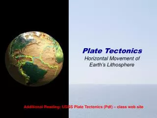
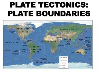
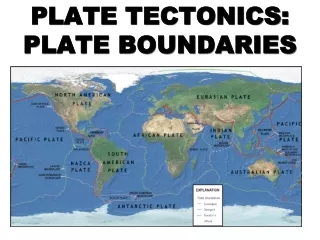
Plate Movement. By: Aaron Fitzsimmons , Alison Hurley , Clodagh Greene and Josh Varzaru . Plate Movement.

E N D
Plate Movement By: Aaron Fitzsimmons,Alison Hurley,Clodagh Greene and Josh Varzaru.
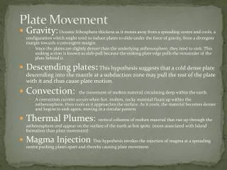
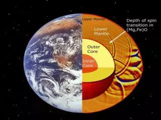
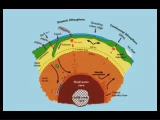
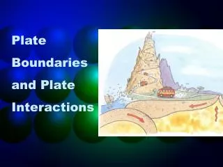
Plate Movement • Why do plates move as they float on top of the mantel?The very hot core heats the magma in the mantel. This sets up convection currents in the mantel. Molten magma moves upwards from the core to the crust. Here it cools and sinks back down towards the core, so that the cycle can start again.There is a friction between the convection currents and the plates. This causes the plates to move slowly on top of the mantel. As a result, the plates may pull apart from one another or collide together.
Continental Drift • The earths continents are passengers on the plate that float beneath them. As the plates move, they carry the continents with them. This movement is very slow and it has taken millions of years for the continents to reach where they are today.The continents began as one large landmass called Pangaea. It gradually began to break up. The individual sections started to drift apart, carried along on the moving plates. This process is known as continental drift.Continental drift continues toady, for example, Europe is slowly moving away from North America.
Earthquakes • An earthquake is a sudden movement or trembling of the earths crust. This movements takes the form of a serious of shocks or tremors. Earthquakes occur at boundaries where plates collide. As the plates push into one another, pressure builds up until one of the plates slips. This eases the pressure and a huge amount of energy is released. The earthquake has occurred.
Aftershocks • Earthquakes rarely last for longer than one minute. Smaller tremors, called aftershocks, may occur in the hours or days following an earthquake. They often cause more damage than the original earthquake because buildings and structures are already weakened by the first tremors.
Measuring Earthquakes • Tremors from an earthquake can be detected and measured by a seismometer or seismograph. A pen on the tip of a seismometer records the tremors on a rotating drum.The Richter scale is used to describe the strength or force of an earthquake. Each increase of one unit on the scale means that the strength of the earthquake is ten times more powerful
Haiti • On Tuesday, January 12, 2010 at 21:53:10 UTC a 7.0 magnitude earthquake struck Haiti at a depth of 8.1 miles. The epicentre was located 15 miles WSW of Port-Au-Prince. Since then there have been 59 aftershocks. A number of these were rather strong aftershocks. The aftershocks have ranged from 4.2 to 5.9 magnitude in strength. The plates involved were the Caribbean Plate and the North American Plate.
Facts on Haiti • This was a 7.0 magnitude earthquake • The exact epicentre of the earthquake in Haiti was located at : 18.443ºN, 72.517ºW. • This was the strongest earthquake to hit Haiti since 1770 • Porte-Au-Prince population is 2,000,000 • 3,000,000 people are in need of emergency aid.
A Tsunami • A tsunami is a wave train, or series of waves, generated in a body of water by a pulsating or abrupt disturbances that vertically displaces the water column. Earthquakes, land slides, volcanic eruptions, explosions and even the impact of cosmic body's , such as meteorites can generate tsunamis, tsunamis can severely attack coastlines, causing devasting damage and loss of life. Tsunamis are often called tidal waves as they may resemble a non-lunar-tidal rush of rapidly rising water rather that big cresting waves reaching the shore . However , the term is tsunamis are not related to tides.
Facts on Tsunami • If an earthquake takes place near a body of water, it means that a tsunami will follow in a short time • If the water along the shoreline recedes dramatically and exposes usually submerged areas it should be interfered that is the through of the tsunami and a crest will follow after a few second of minute. • Some large animals like . Elephants hear the noise of the tsunami and move towards inland • Computers can also for see tsunami arrival and impact depending on the knowledge of the event that caused it and the shape of the ocean bed • There is a large roar simile to a train or aircraft
The Indian Ocean Tsunami • The epicentre of the 9 magnitude quake was under the Indian ocean near the west coast coast of the indoneasian island of Sumatra giant forces that have been building up deep in the earth for hundreds of years, were realised suddenly on the 26 December 2004. shaking the ground violently and unleashing a series of killer waves that sped across the Indian ocean, hitting 11 countries, making it perhaps the most destructive tsunami in history.
Facts on the 2004 Indian Ocean Tsunami • The December 26, 2004 Indian ocean tsunami was caused by an earthquake that is thought to have had the energy of 23,000 atomic bombs • The epicentre of the 9.0 magnitude quake was under the Indian ocean near the west coast of the Indonesian island of Sumatra. • The shifting of the earths plate in the Indian ocean on the December 26.2004 caused a rupture more than 600 mile longs. This was the highest magnitude earthquake in 40 years • Within hours of the earthquake killer waves radiating from the epicentre slammed into the coastline of 11to Indian countries damaging country from the east Africa to Thailand • By the end of the day of the 2004 Indian ocean tsunami, it had already killed 150,000 people. The final death toll was 283,000
Pacific Ring Of Fire • The pacific ring of fire is an arc stretching from new Zealand, along the eastern edge of Asia, north across the aleatian islands of Alaska and south along the coast of north and south America. The pacific ring of fire is com posed of over 75% of the worlds most active volcanoesthis huge ring of volcanic and earthquake activity was noticed and described before the invention of the theory of plate tectonics. We know know that the pacific ring of fire is ,located at the borders of the pacific plate and other major tectonic plates.
Mid-Atlantic Ridge • A mid-ocean ridge is an underwater mountain rang. It is formed where two plates separate.As the plates move apart, molten magma rises from the mantle and fills the gap between the plates. When the magma meets the cold sea water, it cools and solidifies to form a new ocean floor. As the eruptions of magma continue in an endless cycle, the ocean floor is built up to form a long ridge of mountains.The Mid Atlantic Ridge runs north to south, for the full 16,000 km length of the Atlantic ocean. It is so high in places that it is exposed above sea level. One such place is Iceland
Iceland • Iceland is part of the mid Atlantic ridge, that owes its very extension to molten rock or magma, that wells up through the rifts of the ridge. Scientist believe Iceland rose from the sea floor about 20 millions years ago. Continues spreading accompanied by eruptions along Iceland section of the ridge, widens the country's by about one inch per year.