Download
1 / 9
90 likes | 207 Views
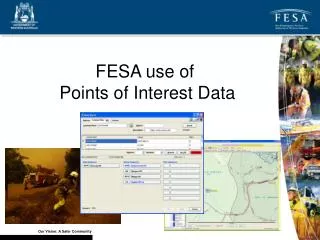
Our vision for a safer community involves effectively using Points of Interest (POI) data for emergency operational support. This includes enhancing search and rescue activities, providing crucial information during bushfire threats, and efficiently managing responses during tropical cyclones, storms, and hazardous materials incidents. The FESA emergency dispatch system utilizes POI data to improve incident location accuracy. With developments in geocoding and external POI data sources, we aim to strengthen community safety mechanisms and response effectiveness.

E N D
FESA use of Points of Interest Data Our Vision: A Safer Community
POI Usage 000 Call Centre (COMCEN) Map Display FCAD SDE Geocoders Data Custodians (Geonoma) Under Development Under Development Mapping Corporate Geodatabase FESA POI Processing Corporate GIS Analysis Data Storage FESA Data Collection Emergency Operational Support SLIP-EM Functions to be decommissioned in 2011 Our Vision: A Safer Community
Corporate/Operational Value • Adds value to an all hazard approach to operational and corporate map products: • Search and Rescue – e.g. refuge locations, waterholes etc • Bushfire – e.g. water access points, critical infrastructure locations • Tropical Cyclone – e.g. mining camps, tourist locations • Storm and Flood – e.g. homesteads/shearing sheds, fuel points • HAZMAT – locations of significant risk and hazardous goods Our Vision: A Safer Community
Emergency Dispatch • FESA’s emergency dispatch system FESA CAD (FCAD) uses POI data as one of 4 searchable fields (others are RCL, PSA and Cadastre) • POI “Common Place” is third level of FCAD searching (after PSA and RCL) however is still a very important component in the location of incidents in non-residential areas • POI provides a better percentage result on poorly referenced 000 calls through to COMCEN Our Vision: A Safer Community
Common Place Searching • The FCAD algorithm will automatically geocode the 000 call details entered firstly through PSA, then RCL, then to POI until a match is achieved • COMCEN operators can also choose to perform a ‘common place’ search manually Our Vision: A Safer Community
FCAD Turnouts Response Instructions differ significantly from a scrub/bush turn-out as apposed to residential location. POI search on “Star Swamp Reserve” will ensure correct appliances respond to this type of incident. Our Vision: A Safer Community
Data Available in FESA POI External Data Sourced for POI Data developed by FESA for POI SSD Facilities Bus Stops Geonoma Post Boxes Schools Rest Areas Railway Stations Consulates Medical Facilities Political Offices Mining Locations Indigenous Communities Petrol Stations Public Toilets Licensed Premises Shopping Centres Supermarkets Post Offices (in development) Fast Food Franchises Our Vision: A Safer Community
POI Building • Information collated into POI spreadsheet via research (business websites, White Pages and Google Streetview) • Data geocoded for match address and spatial joins applied to shapefiles. Known Business Address Geocoding Match address on PSA Our Vision: A Safer Community
POI Developments Needed • Addition of ‘alias tables’ to strengthen common place searches • Addition of full facilities guide as per Streetsmart (any facility with occupancy) i.e. caravan parks, churches, taverns/motels etc • Regional areas heavily reliant on geographical features for POI searching so needs to be comprehensive • Feedback mechanism developed for POI management to move away from FESA responsibility Our Vision: A Safer Community