Download
1 / 7
70 likes | 364 Views
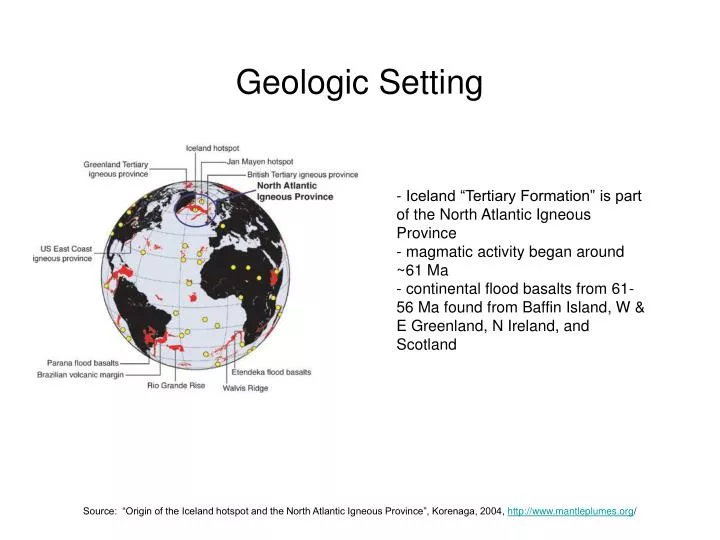
Geologic Setting. - Iceland “Tertiary Formation” is part of the North Atlantic Igneous Province - magmatic activity began around ~61 Ma - continental flood basalts from 61-56 Ma found from Baffin Island, W & E Greenland, N Ireland, and Scotland.

E N D
Geologic Setting - Iceland “Tertiary Formation” is part of the North Atlantic Igneous Province - magmatic activity began around ~61 Ma - continental flood basalts from 61-56 Ma found from Baffin Island, W & E Greenland, N Ireland, and Scotland Source: “Origin of the Iceland hotspot and the North Atlantic Igneous Province”, Korenaga, 2004, http://www.mantleplumes.org/
Icelandic Rift Zones - WVZ and NVZ (western and northern volcanic zones) represent the current mid-ocean ridge track - EVZ is propagating to the south - SISZ = south Iceland seismic zone, connects WVZ and EVZ - EVZ represents a juvenile ridge zone; eventually the mid-ocean ridge will jump from the WVZ to the EVZ Source: “Tertiary Volcanism in Iceland”, Harðarson et al., Jökull, 2008.
Icelandic Hot Spot Track - Greenland, Iceland, Faeroe “ridge” represents a hot-spot trail - proto-Iceland may have been formed off the east coast of Greenland (hot spot reached East Greenland coast between 40-35 Ma) - connected by a trail of small islands or a land bridge (supported by paleobotanical evidence, Grimmson et al. 2007) Source: “The Faeroe-Iceland-Greenland Aseismic Ridge and the Western Boundary Undercurrent”, P. R. Vogt, Nature, Sep. 1972
Icelandic Volcanoes Tertiary = 16 to 3.3 Ma Plio-Pliestocene = 3.3 to 0.78 Ma Upper Pliestocene = 0.78 Ma to 15000 yr BP Holocene = 15000 yr BP to present -- tertiary volcanoes = open, unfilled circles -- Plio-Pliestocene = crossed, unfilled circles -- active volcanoes = brown, filled circles Source: “Tertiary Volcanism in Iceland”, Harðarson et al., Jökull, 2008.
Volcanic Hazards plinian eruption of Hekla in 1947 (plume reached 28 km) lava and tephra deposits covering a small town by Eldfell eruption in 1973 a jökulhlaup glacial outwash plain destroying a section of the ring road (Highway 1) Source: “Volcanic Hazards in Iceland”, Gudmundsson et al., Jökull, 2008.
Volcanic Hazards -- tephra fallout isopach map -- fallout of >10 cm can cause roof cave-ins -- can cause problems with farming (as in 1619, 1873, 1903 eruptions of Grimsvötn) -- historical eruptions have had plumes from 8-15 km -- map of historical and prehistoric lavas -- pyroclastic flows are not common, although the subplinian Hekla eruption in 2000 produced flows up to 5 km from the vent Source: “Volcanic Hazards in Iceland”, Gudmundsson et al., Jökull, 2008.
Jokülhlaups -- jokülhlaups: glacial outwash floods -- can be caused by geothermal activity or by volcanic eruption-- 1 to 1.5 hours to notify and evacuate areas -- water depth exceeding 1 meter and flow velocities > 1 m/s -- 300,000 m3/s of material discharged Source: “Volcanic Hazards in Iceland”, Gudmundsson et al., Jökull, 2008.