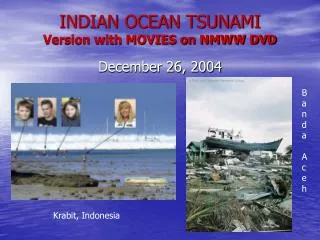
Chapter 15: Ocean Basins
Chapter 15: Ocean Basins. Tubeworms, tiny crabs and other sea life use heat, minerals and chemical energy near hot water vents on the deep sea floor to survive without sunlight.

Chapter 15: Ocean Basins
E N D
Presentation Transcript
Tubeworms, tiny crabs and other sea life use heat, minerals and chemical energy near hot water vents on the deep sea floor to survive without sunlight.
“Bolide” impacts may have brought volatiles to the inner planets, which eventually formed our atmosphere, oceans and foundation for life on Earth. • See page 376 for an explanation of this drawing. Fig. 15-1, p.354
The Earth’s Oceans • Oceans cover about 71% of the Earth’s surface. The seafloor is about 5 km deep in the central part of ocean basins. Oceans basins are continually changing. What is happening with the Pacific and the Atlantic ocean basins? (one is closing while the other is enlarging)…Why does water eventually end up in the oceans? (read on the density of oceanic crust, Page 377). • Oceans affect global climate and the biosphere in many ways: • They reflect and store solar heat different than rocks/soil (oceans are generally warmer in the winter and cooler in the summer than adjacent land). • Most precipitation is from evaporation from oceans. • Ocean currents transport heat toward poles. • Plate tectonics alters basins which alters currents and affect climate.
Halley’s Comet. The early Solar System was crowded with comets, meteoroids and asteroids. Bolide impacts may have imported volatiles such as CO2, water vapor, ammonia, simple organic molecules and other volatiles. Fig. 15-2, p.354
Schematic cross section of the continents and ocean basins. Vertical axis shows elevation relative to sea level. Horizontal axis shows the relative areas of the types of topography (e.g., mountains and ocean floor). Fig. 15-3, p.355
Studying the seafloor: Oceanographers extract sediment from a core retrieved from the seafloor. Fig. 15-4, p.356
Alvin is a research submarine capable of diving to the sea floor. Scientists on board control robot arms to collect sea-floor rocks and sediments. Fig. 15-5, p.357
Mapping the topography of the sea floor with an echo sounder. A sound wave bounces from the sea floor and back up to the ship, where its travel time is recorded.
A seismic profiler records both the sea floor topography and the layering of sea floor sediments and rocks. Fig. 15-6b, p.357
Features of the Sea Floor Fig. 15-7, p.358
The Mid-Oceanic Ridge System (MORS) and other features of the sea floor show there is as much topography here as on the continents. MORS is a continuous submarine mountain chain that encircles the globe; it rises 2-3 km above the sea floor, and is Earth’s largest mtn chain (covering 20% of its surface).
Divergent plate boundaries, or spreading centers, coincide exactly with the MORS in the world’s oceans. Fig. 15-7b, p.358
The sea floor sinks as it grows older. At the MORS, new lithosphere is buoyant because it is hot and of low density. It ages, cools, thickens and becomes denser as it moves away from the ridge and sinks. The central part of the sea floor lies at a depth of about 5 km. Fig. 15-8, p.360
A cross-section view of the central rift valley of the MORS. As the plates separate, blocks of rock drop down along the fractures to form the rift valley. The moving blocks cause earthquakes along “normal” faults. Fig. 15-9, p.360
Transform faults offset segments of the MOR. Adjacent segments of the ridge may be separated by steep cliffs 3 km high. Note the flat abyssal plain far from the ridge. Fig. 15-10, p.361
The MORS can cause a rise and fall in global sea level (if they didn’t exist, sea level would fall 400 meters). Slow spreading (above) creates a narrow, low-volume ridge that displaces less sea water and lowers SL. • Rapid sea floor spreading (right) creates high-volume ridge, displacing more sea water and raises SL. Fig. 15-11, p.361
Life on the Mid-Oceanic Ridge. • Black smoker to right (see page 384). Fig. 15-12, p.362
Oceanic Trenches and Island Arcs: An oceanic trench forms at a convergent boundary between two oceanic plates. One plate sinks, generating magma that rises to form a chain of volcanic islands called an island arc. Fig. 15-14, p.362
Onekotan is one of many volcanic islands in the Kuril Island arc that formed along the Kuril trench in the western Pacific. The deepest place on Earth is the Mariana trench of the sw Pacific, where the ocean floor sinks to about 11 km below SL.
Island arcs eventually migrate toward a continent and becomes part of it (to buoyant to sink). This is a way continents can grow by accreted terranes. Fig. 15-16, p.363
The accreted terranes of western North America are micro-continents and island arcs from the Pacific Ocean that were added to the continent. Fig. 15-17, p.364
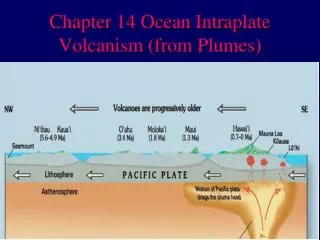
Seamounts, Oceanic Islands and Atolls • Seamount: submarine mtn that rises 1 km or more above the ocean floor. • Oceanic Island: is a seamount that rises above sea level. -both are volcanoes commonly made of basalt formed at a “hot spot” above a mantle plume. As the plate overrides the hot spot, the seamount becomes inactive. The Hawaiian Island-Emperor Seamount Chain is an example (15.18). As the seamounts move away they erode into a flat-topped “guyot” and sink.
The Hawaiian Island-Emperor Seamount Chain becomes older in a direction going away from the island of Hawaii. In 10-15 million years the island of Hawaii may sink and become eroded. Fig. 15-18, p.365
The Hawaiian Islands and Emperor Seamounts sink as they move away from the mantle plume. Fig. 15-19, p.365
Formation of a guyot. Fig. 15-20, p.366
A fringing reef grows along the shore of a young volcanic island. As the island sinks, the reef continues to grow upward to form a barrier reef that encircles the island. Finally, the island sinks below sea level and the reef forms a circular atoll.
The Tetiaroa Atoll in French Polynesia formed by the process described in Figure 15.22. Over time, storm waves wash coral sands on top of the reef and vegetation grows on the sand. Fig. 15-21, p.366
Sediments and rocks of the sea floor. • The three layers of oceanic crust are layer 1: sediment (Terrigenous and Pelagic); layer 2: pillow basalt and layer 3: upper mantle (basalt dikes and gabbro). • The oceanic crust is 4-7 km thick (1-2 km of pillow basalts and 3-5 km of dikes/gabbro). Fig. 15-23, p.368
Terrigenous sediment is sand, silt and clay eroded from the continents and carried to the deep sea floor by gravity (rivers, landslides) and submarine currents. • Pelagic sediment collects even on the deep sea floor far from continents (clay and remains of tiny plants and animals). It accumulates at a rate of 2-10 mm/1000 yrs. Near the MOR there is virtually none (why?). Fig. 15-24, p.368
Pillow lavas…how do they form? Fig. 15-25, p.368
Continental margins. Fig. 15-26, p.370
Continental crust fractured as Pangea began to rift. Fig. 15-26a, p.370
Faulting and erosion thinned the crust as it separated. Rising basaltic magma formed new oceanic crust in the rift zone. Fig. 15-26b, p.370
Sediment eroded from the continents formed broad continental shelves on the passive margins of North America and Africa. Fig. 15-26c, p.370
A passive continental margin consists of a broad continental shelf, slope and rise formed by the accumulation of sediment eroded from the continent. • Submarine canyons are deep valleys from the edge of a continent to the rise (where abyssal fans may form) and occur where large rivers enter the sea. Sediments from rivers create turbidity currents that can travel as speed greater than 100 km/hr for up to 700 km. Fig. 15-27, p.371
At an active continental margin an oceanic plate sinks beneath a continent, forming an oceanic trench. The continental shelf is narrow, the slope is steep and no rise exists. Fig. 15-29, p.372