Download
1 / 26
320 likes | 463 Views
LiDAR ApplicationsOverview. Summer 2012. Definition. LiDAR: Li ght D etection A nd R anging. Basic Principles. Combination of 3 technologies Laser Ranging GPS IMU Active Sensor Can be acquired at night Platforms Fixed or Rotary Wing Aircraft Terrestrial; Vehicle & Tripod.

E N D
LiDAR ApplicationsOverview Summer 2012
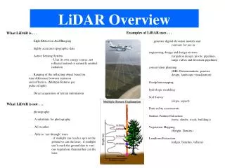
Definition LiDAR: Light Detection And Ranging
Basic Principles • Combination of 3 technologies • Laser Ranging • GPS • IMU • Active Sensor • Can be acquired at night • Platforms • Fixed or Rotary Wing Aircraft • Terrestrial; Vehicle & Tripod
Basic Principles IMU
Basic Principles Pulse Repetition Frequency (PRF) Multi-pulse (in air) Multiple Returns Scan Frequency Scan Angle Platform Speed and Altitude Intensity
LiDAR Categories Terrestrial Topographic Bathymetric Mobile Static Fixed Wing Rotary Wing Aerial
Aerial Sensors Examples: Optech Leica Riegl
Fixed Wing Cabin Footprint:
Fixed Wing Wide Area Mapping FloodPlains Counties/States Forestry Applications Landfills/Quarries/Volume Analysis Most 1’ & 2’ Contour Interval Projects Typical Applications:
Fixed Wing 500m – 2000m AMT 70kHz – 200kHz Point Spacing .5m – 2m (Single Swath) Swath 200m – 1km and higher Focus on covering more ground, more quickly Typical Parameters:
Rotary Wing GeoDigital International
Rotary Wing Corridor Mapping DOT Transmission Typical Applications:
Rotary Wing Acquisition a couple hundred feet above the ground Upwards of 200kHz 10-30 points per meter Swath 200’-1000’ Focus on max point density for small feature ID Typical Parameters:
Static LiDAR Examples: • Leica HDS – Scan Station • Riegl VZ-400
Static LiDAR Refineries Substations Intersections Pipes Lock Walls Caves/Mines Typical Applications:
Static LiDAR Usually tripod based within a couple hundred feet of target Several points per square foot to several points per inch Usually accompanied with imaging sensor for RGB assignment Controlled with prisms occupying surveyed control points Focus on max point density for small feature ID and modeling Typical Parameters:
Mobile LiDAR Examples: Optech Lynx Street Mapper
Mobile LiDAR Several points per square foot Usually accompanied with imaging sensor for RGB assignment Controlled with targets occupying surveyed control points Focus on max point density for small feature ID Data often adjusted to control established by level loop for high accuracy grading Typical Parameters:
Mobile LiDAR Corridor Mapping DOT Street Level Visualization Transmission Rail Corridors/Tunnels Typical Applications: